9
$\begingroup$

I have asked previously how I could create an earth-like world with as many deserts as possible in it. I have received some useful answers and have tried to draw a realistic map of what I intend for my continent.

Unfortunately, I have been having trouble using Geoff's Climate Cookbook... if you ask me, it is not very user friendly for someone with no basic knowledge of meteorology, at least before we get the hang of it (and I don't think I got it, not for a long shot). I'm very confused, especially since a vast expanse of my continent rests on the south hemisphere and not the north, which means I have to invert a lot of things.

So, I would like to ask you if you think this map is plausible.

(I'm sorry if it is somewhat simplistically drawn, but I don't want to draw a very detailed continent to find out at the end that it isn't plausible)
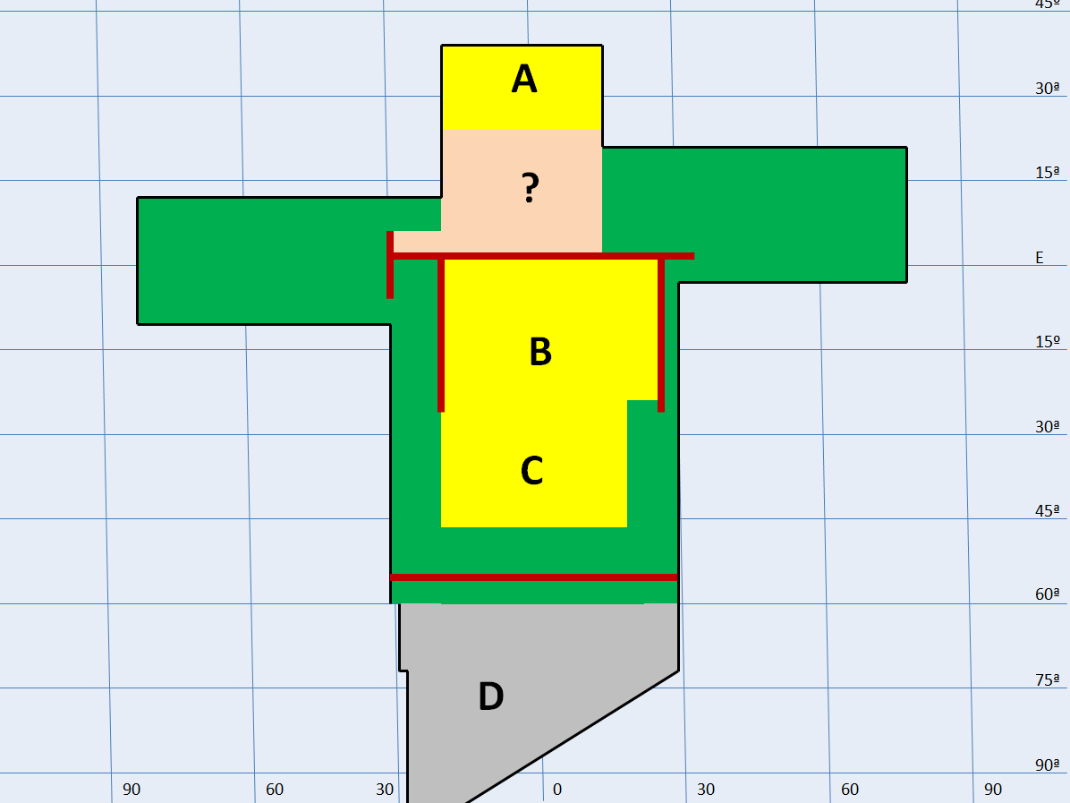
enter image description herePlease read the edit at the bottom of the post

  1. Blue lines: Latitude and longitude (check right and bottom of the screen)
  2. Black lines: Limits of the continent
  3. Reddish thick lines: Mountain ranges
  4. Blue area: Ocean
  5. Green area: Fertile regions, with relatively high precipitation (irrespective of being tropical, temperate or whatever)
  6. Yellow area: Hot desert
  7. Grey area: Cold desert
  8. Orange area: I don't know which climate to assign to this area

Now, I don't want to dwell on the green areas just yet. If you would like to help me with the "?" area climate, I'd appreciate it, but I'm willing to make a separate question for it, in order to not have my question closed for being too broad.

What I want to know is if the desert areas are well placed.

Area "A": I know it's a stretch, but I was thinking that it could be a coastal desert, dried up by the Hadley cells. I only want it to be plausible, not probable

Area "B": Hot desert created by the rainshadow of the mountain ranges in the east, west and north

Area "C": Hot desert created by a large expanse of land in the Hadley cell

Area "D": Cold desert (it's okay if there is some precipitation on it, in the form of snow)

Please note: This is an earth-like planet, with the same size as earth and the same duration of days and years. However, it has almost no axial tilt, in order to maximize extreme weather and to avoid the monsoon effect

EDIT: As of July, 17th, I have redrawn my map so that areas A and C would fall more in line with 30º latitudes

$\endgroup$
14
  • 1
    $\begingroup$ Czech Republic sits comfortably between four mountain ranges, and it isn't desert. Why? $\endgroup$ Commented Jul 16, 2017 at 9:51
  • 1
    $\begingroup$ I would expect you to see moist air moving around the mountains to take the path of least resistance. So around the boundary between B and C where the mountains end you should get some rainfall. $\endgroup$ Commented Jul 16, 2017 at 10:17
  • 1
    $\begingroup$ I see what you mean. I'd simply shave some of B's south side off and move C a little farther north. Then, it should land within your intended area. $\endgroup$ Commented Jul 16, 2017 at 11:09
  • 1
    $\begingroup$ Also, though I am not 100%, I would believe your orange area would probably be either more desert or a dry plains area. $\endgroup$ Commented Jul 16, 2017 at 11:11
  • 2
    $\begingroup$ @JanDvorak - Probably because of rivers? $\endgroup$ Commented Jul 16, 2017 at 12:56

3 Answers 3

4
+250
$\begingroup$

A

This desert is mostly appropriate. An analogy to this continental feature is the southern part of Africa. Most of this is the Kalahari desert, especially on the Eastern side. If your planet rotates in the same direction as Earth, you will have a similar gradient of dry desert on the east to semi-arid savanna on the west. There is even a bit of wet savanna on the far western coast.

Cape Town has a nice Mediterranean climate at 33 S, so if your continent extends north past ~30-35 or so, you can expect a Mediterranean climate to develop.

B

Anything within a few degrees of the Equator will be a rainforest. Even the northern half of Africa, which quickly grades into the Sahara Desert, is relatively wet, up to about 4 degrees N at Bangui. Therefore, your mountains would be expected to be very wet, with lots of small rivers coming down to feed a rainforest pushing out to about 5 degrees from the equator.

Savanna would then persist up to at least 10 degrees north. In Africa, N'Djamena is at 12 N but still wet enough to support agriculture in river valleys and herding on the open plains.

South of 10-15 it would become true tropical desert. With the mountains you mention, the land would be drier, but still not a desert. An example from Earth would be Dodoma, Tanzania. It is surrounded on three sides by mountains at 6 degrees S, but is not a total desert.

A more unique situation of a city in tropical desert surrounded on three sides by mountains is Lodwar, Kenya. However, in that case, the desert basin is small, a portion of the Eastern Rift Valley. Your continental scale depression between mountains will accrue enough moisture into it (from rivers from the equatorial mountains) that it won't get that dry.

C

There are many deserts at this latitude, but you need to cut them off from the ocean. A west coast between 30-45 degrees from the Equator is Western Europe, and East coast is either China or the Eastern US. All of them are pretty wet. Instead, you want the western US. Cut off between the Coast ranges and the Rockies, the interior great basin of the US has the same latitude range you want. Extend those red mountains south enough to cut off the land from moisture carried in prevailing winds at sea.

D

Polar regions are pretty much deserts. The taiga cuts out between 60 and 70 N and thereafter it is tundra.

?

Assuming your planet rotates the same way as the Earth, this area will get significant rainfall from the rainforest and ocean regions to the West of it. Prevailing equatorial winds will blow moisture in year round.

Since we already determined that A is like the southern part of Africa, this region is remarkably similar to Central Africa, complete with a jutting projection of rain forest analogous to West Africa.

In general, the areas closer to the coast will be a bit drier, and in the center of the continent a bit wetter; but the 'armpit' of land on the west coast will see heavy monsoons. Typical rainfall regimes might be like Douala, Cameroon in the 'armpit'; Port Gentil, Gabon northwards along the coast (note the two distinct rainy seasons); a drier Kinshasa in the coastal regions; and a wetter Kisangani in the interior. As you head north, it will turn into savanna by at least 6-8 N.

Conclusion

Africa is pretty dry all in all, and a good continent for you to use as a model. Just keep in mind, especially in southern Africa, Africa also tends to be the highest continent. Most of the southern half of the continent is at 1000m +. If you are copying climate conditions, make sure you make it warmer if your places are at lower elevation.

$\endgroup$
6
  • $\begingroup$ Thank you for your answer. I'm a little disappointed by B, since I thought that very high mountain ranges would be enough to dry the moisture, even in the equator. Does this moisture come to B only from the rivers you mentioned or is there another way? Do those rivers forcefully flow to B or can the flow outward? $\endgroup$ Commented Jul 18, 2017 at 6:29
  • $\begingroup$ Also, do you have any ideas how I can "de-fertilize" those green areas, especially between C and D? It doesn't have to be a desert, any kind of wasteland will do. (Note, I'm interested only in natural explanations, not man-made) $\endgroup$ Commented Jul 18, 2017 at 6:31
  • $\begingroup$ For de-fertilizing, try a miombo forest. These develop in South Africa between the rainforest and desert on poor soils. Since these have a closed canopy of short (10m or less) trees, there is little grass, so there is little (lage) wildlife. No big game plus poor soils means the human population density is very low, and concentrated around wetlands. $\endgroup$
    – kingledion
    Commented Jul 18, 2017 at 7:19
  • $\begingroup$ @PedroGabriel The moisture is going to come from rainfall as well as rivers. The natural rainfall within 5 degrees of the equator will support forest, the respirating trees with then retain moisture and keep the region relatively wet during the dry season. The rivers coming down from the mountains just add more moisture. Remember, that the mountains both keep outside moisture from entering, but prevent inside moisture from leaving. $\endgroup$
    – kingledion
    Commented Jul 18, 2017 at 7:20
  • $\begingroup$ Been to the polar region and the tundra, didn't look like a desert to me $\endgroup$
    – Raditz_35
    Commented Jul 18, 2017 at 8:33
6
$\begingroup$

? could be either desert on grassland believably, in fact it should probably extend further east. the intertropical convergence will drop some rain especially close to the mountains but not a lot. The top of A will be prime fertile territory, placement wise it should be nice and fertile not desert. 40 degrees is where most of our prime farmland is.

C should be more fertile, especially the lower and western portion, at 60 degree latitude it will have more rain, it is basically similar to europe or the lower portion of canada, at worst you could make it savannah. The top of D will be more fertile as well, climatically it is more like sweden with lots of forests. deserts are spread more laterally than vertically.

Check similar latitudes on earth for inspiration. hot deserts cluster around 30 degrees while prime farmland is near 45-50 degrees. Basically almost all your climates extend too far vertically. Of course the less detailed the map the less detailed you can make the weather patterns.

Also this geologic make up is going to have volcanics on the eastern mountain range at least, you don get mountains that close to the coast without active subduction. And if the two western and the one northern mountain ranges are still being pushed up (or to a lesser extent even if they are not), you are going to end up with something like the himalayas there as well. At -25 longitude and 0 latitude you have several continental plates being pushed together, you will have some widespread mountains not narrow bands, that whole region could become rugged highland or highland plateau depending on if it is still being formed or not, that will give you a highland desert.

For the revised map the fertile belt on D will be much larger, just look at earth you have green fertile land all the way to 70 degrees for at least part of the year. There are ways to change that, greenland is colder because it is isolated by water channels or you could make it high elevation like the himalayas just nearer to the poles, that will create a fertile belt on one side or the other from all the rain dropping out but the rest will be mountainous and dry. since it is continent to continent plate forming the mountains you will end up with some widespread mountains anyway.

$\endgroup$
8
  • $\begingroup$ Would the mountain ranges change any of that? $\endgroup$
    – Tim B
    Commented Jul 16, 2017 at 14:10
  • 1
    $\begingroup$ yes which is why B is fine, but you don't have mountains in most other places. and even mountains can only do so much compared to latitude, the central US has mountains on both sides for instance and part of it is our prime farmland. Prevailing winds also move vertically as well as horizontally so they will bend a bit around many of your mountain ranges. $\endgroup$
    – John
    Commented Jul 16, 2017 at 14:16
  • $\begingroup$ @John: Thank you for your answer. As I said in a comment in the OP: I see now that my map has some flaws in it, since C was meant to be exactly between 30 and 45º, to take advantage of the Hadley Cell. I think I extended C too much southward from what I intended $\endgroup$ Commented Jul 16, 2017 at 14:23
  • $\begingroup$ @John: IOW, if I move A a little south and C a little north, so that both would rest more in the 30º area, would I achieve the desired effect? $\endgroup$ Commented Jul 16, 2017 at 14:26
  • 1
    $\begingroup$ Compressing the continent vertically would have the desired effect, although it will depend on how it is centered. Also if you do this D will become prime fertile land. Moving the regions will work as well provided you shrink them vertically at the same time. $\endgroup$
    – John
    Commented Jul 16, 2017 at 21:31
2
$\begingroup$

When you want little more realistic earth-style map then try to spread deserts little more horizontally around equator where suns intensity is highest assuming planetary axial tilt is small.

However in case you have more freedom with background story, you could consider case where planetary rotational plane is nearly perpendicular (~ 90°) to orbital plane and facing sun with one of its poles.

Then again you could create other good reason for desert being there like ancient nuclear war or surrounding high mountain ranges which block humid air reaching specific area.

If you want get random map in easy way then I suggest you could try Civilization or some other computer game which may generate suitable map for you with minimal effort.

EDIT: Keep in mind that usually story is much more important then map and also keep in mind that your world - you can set rules. Then again, if you want my (realistic) viewpoint then area C would likely be very windy and might require some extra condition to become desert. Perhaps try curve that lower red line little more around edges of other red lines.

$\endgroup$
4
  • $\begingroup$ @Pedro is asking for help to finalize HIS set up, not asking for a change to it. $\endgroup$ Commented Jul 16, 2017 at 11:50
  • $\begingroup$ No offense but maybe try reading again what he was asking. While I did not give direct answer, I gave few ideas which may lead him to good setup. $\endgroup$
    – user40520
    Commented Jul 16, 2017 at 12:16
  • 1
    $\begingroup$ @Nomaeitea: Welcome to Worldbuilding! I appreciate your answer, and I do agree that story is more important than map. However, this question carries a "reality-check" tag, which means that the scope of this question is about the plausibility of this world. This site is very strict about these rules (I'm a little more lax, but I'm not a site administrator) so I advise you to accustom yourself with tags to understand how you should formulate an answer to the posed question. I do believe that your answer is good, but should be posted on my first question, which I linked. $\endgroup$ Commented Jul 16, 2017 at 13:16
  • $\begingroup$ In map generation, Dwarf Fortress is king. $\endgroup$ Commented Jul 16, 2017 at 13:19

You must log in to answer this question.

Not the answer you're looking for? Browse other questions tagged .