16
$\begingroup$

I'm designing a world, and I want it to have major geological changes over a short period of time. This includes continental drift, which I'm assuming should have some interesting results. In particular, I'd like to have mountains form, which in turn should change part of the world's climate (I'm guessing) by impacting wind patterns. However, while I'd like all of this to happen rather quickly, I don't know just how fast it can happen, as I don't know how fast continents may move and then collide.

Here are my parameters:

  • The planet is Earth-like, with the same sort of seasons.
  • There are four large continents, each about the size of Africa, spread across the globe.
  • I want the mountains to form quickly, ideally reaching heights of 30,000 feet within a few million years from the start of a collision. They'll probably keep going, but this is my target reference height.
  • The area where they'll form was previously mostly flat.
  • The whole chain should be roughly 1,000 miles long.

Is it possible for these mountains to form in about a million years? If so, can they form faster? If not, how much longer would it take?

$\endgroup$
7
  • $\begingroup$ When you talk about continental drift are you using it as analogous to the drift in tectonic plates? (these are what butt together to push up and form mountains). Are your continents restricted to single tectonic plates? $\endgroup$ Commented Mar 13, 2017 at 13:48
  • $\begingroup$ @LioElbammalf I thought continental drift was the same as the drift in tectonic plates. If not, feel free to correct me. At any rate, I intended for the continents to be on individual plates, so maybe this is moot. $\endgroup$ Commented Mar 13, 2017 at 13:50
  • $\begingroup$ It is a moot point if it is a continent per tectonic plate. Continental drift is caused by tectonic plates shifting but a continent isn't necessarily limited to sitting one tectonic plate. Are your continents separated by sea? Or all together? $\endgroup$ Commented Mar 13, 2017 at 14:25
  • $\begingroup$ If you like the existing answers, remove the hard-science tag (use science-based instead. Maybe that’s what you meant? As a newcomer you might not have noticed that the former is special. $\endgroup$
    – JDługosz
    Commented Mar 13, 2017 at 20:48
  • $\begingroup$ @JDługosz I appreciate that, but I've done read through the tag wiki and a bunch of meta posts, and I definitely mean the hard-science tag. $\endgroup$ Commented Mar 13, 2017 at 22:00

4 Answers 4

24
$\begingroup$

How the Himalayas were made

Mountain formation isn't the best known process in the world. The general process for the formation of the Himalayas is described in Wikipedia, as are the various disagreements on the pre-Himalayan geology.

The general subject for disagreement is which parts of the Indian and Eurasian plates along with the Tethys seabed ended up where. Le Fort, 1975 extensively documents the known (in 1975) ages of deposits in various parts of the Himalaya. The general facts are, and this is well illustrated by Fig. 2 from the paper on page 4, that there are some regions of the Himalaya where surface deposits are Triassic in origin (200-250 mya), while other areas such as Kumaun district of Uttarakhand state have deep Eocene marine sediments as young as 40 mya.

These deposit ages are relevant as they determine the actual timeline for how long the Himalayas took to form. India started colliding with Eurasia around 55 mya, and the aforementioned marine sediments were deposited on the bottom of the Tethys Sea as recently as 40 mya, indicating that what is currently the Himalayas definitely did not exist as of that time. Page 15 of Le Fort shows evidence for a terrestrial coastal environment as recently as 26 mya, an analysis echoed in Najman, et al., 1997.

The timeline suggested in Tapponnier, et al., 2001, graphically described in Fig 3., page 1674, suggests that there was an initial period of mountain building starting with the Bangong suture up to 120 mya. This was caused by a India ripping a piece of Africa off when it separated from Gondwana. This detached crust piece was the Lhasa terrane, which was pushed pushed by India into Eurasia and built the first piece of the Tibetan Plateau. This collision formed a volcanic region called the Gangdese batholith.

After this collision, there was still the Tethys sea between India and Eurasia; the Lhasa terrane was separated from India by oceanic crust. It took tens of millions of years to close what was left of the Tethys sea. The rest of the continent of India didn't start to collide with Eurasia until about 55 mya. This collision re-ignited the Gangdese volcanic belt and causing the Jinsha suture to rise from from 50-20 mya. This phase of the collision probably coincided with volcanic mountain building of the same sort that made the Andes and Cascades in the Americas. A detailed (and very readable for a paper, in my opinion) description of this phase is in Jain, 2014.

Finally, about 25 mya, the subduction could no longer continue smoothly and a massive thust-fold belt formed what is now the Himalayas. The previous volcanic mountains are now part of the sub-ranges of Tibet such as Nyenchen Tanglha Shan. Sorkhabi and Stump, 1993 argue from isotropic evidence of changing fluvial (river) patterns, that there were three major pulses of uplift, between 21-17 mya, 11-7 mya, and starting 2mya to present. This is summarized on page 89-90 of their paper. During those times (and indeed during the present) the mountains would have risen at rapid rates.

Over at Earth Science SE, there are a few posts talking about maximum possible heights of mountain ranges. Without going too much into detail, the Himalayas are probably about as tall as mountains can possibly get; since at about 8000-9000m, erosion rate from glaciation starts to exceed maximum possible uplift. So the conclusion from Sorkhabi and Stump is that for those three pulses, including the one at present, the Himalayas were about as tall as they are now.

Conclusion: How fast can they rise

The available evidence suggests that the material that currently makes up the Himalayas was a coastal plain as recently as 25 mya. By 21 mya it was being uplifted at a rate that caused its height to be capped by erosion at about the height we see today. So we are looking at 4 million years to form these mountains from 'nothing.'

However, this does come with caveats. The Himalayas didn't form from 'nothing' but from a foreland basin, that was 'sunk' between the higher elevation Indian shield and behind it and the Tibetan Plateau, which had already existed for 75 million years in front of it. The Tibetan Plateau, in particular, was already pretty high, and had ranges of volcanic activity that had built mountains there for the past 40 million years.

An analogy to the situation in today's world would be this. The Persian Gulf and Mesopotamia is a foreland basin between the Iranian Plateau in front of it, and Arabia behind. The Gulf could (if the plates were lined up just right) rise into Himalaya-sized mountains in 4 million years. However, there would already have been a significant mountain range in the area before this 4 million year orogeny started; they just wouldn't seem so significant once there were 8000m peaks towering over their southern border.

Final TL;DR conclusion: Himalaya-size mountains could form in as little as 4 million years from a shallow sea, but there would already have been volcanic mountains from the subduction zone in the area for tens of millions of years.

$\endgroup$
5
  • $\begingroup$ This is a really fantastic answer. I'll try to read some of those papers, when I get a chance. $\endgroup$ Commented Mar 13, 2017 at 16:30
  • $\begingroup$ I thought they don’t (just) erode at the same speed, they slump, spreading forward instead of upward. $\endgroup$
    – JDługosz
    Commented May 9, 2017 at 14:19
  • $\begingroup$ @JDługosz What phase of mountain building are you talking about? During the fast-rising phase, there is little spreading or slumping. The subducting crust being rammed downwards into the mantle sort of prevents settling until after the action stops; then in between the fast moving phases, the whole range will settle and spread.The erosion part is mostly related to glaciers, and doesn't have as much to do with the mountain uplift rate. The high mountains + heavy monsoon snowfall causes lots of glaciers which erode mountains faster than they can rise at 8000-9000m $\endgroup$
    – kingledion
    Commented May 9, 2017 at 14:28
  • 1
    $\begingroup$ I saw a science show where it was physically modeled using silly-putty-like materials, arranged in layers to match pre-himalaya geography, with a ram pushing the model India up into it. Ran overnight, shooting time-lapse photography. $\endgroup$
    – JDługosz
    Commented May 9, 2017 at 14:37
  • $\begingroup$ I don’t remember. $\endgroup$
    – JDługosz
    Commented May 9, 2017 at 22:19
12
$\begingroup$

Your closest comparison here is the Himalayas

The Geological Society says on this:

The Himalayas are still rising by more than 1 cm per year as India continues to move northwards into Asia

That rate of rise gives you 10,000metres/million years. Limited by the rate of erosion, but your high speed mountain target is reasonably achievable.


It's possible that mountains could pop up very quickly (on geological timescales).

Two new studies by a University of Rochester researcher show that mountain ranges rise to their height in as little as two million years

"Deblobbing" may not sound like a very scientific word, but it's the term given to a dense root beneath the Earth's crust—a blob—that becomes unstable and begins to flow downward into the earth's mantle under the force of its own mass, until it detaches. When two tectonic plates collide, such as the Nazca oceanic plate in the southeastern Pacific colliding with the South American continental plate, the continental plate usually begins to buckle. Floating on a liquid mantle, the plates press together and the buckling creates the first swell of a mountain range.

Below the crust, however, there also is a kind of buckling going on in the solid portion of the upper mantle. This dense mantle root clings to the underside of the crust, growing in step with the burgeoning mountains above. This dense root acts like an anchor, weighing down the whole range and preventing it from rising, much like a fishing weight on a small bobber holds the bobber low in the water. In the case of the Andes, they swelled to a height of about one kilometer before the mantle root beneath them disconnected and sunk into the liquid mantle. The effect was like cutting the line to the fishing weight—the mountains suddenly "bobbed" high above the surrounding crust, and in less than 3 million years, they had lifted from one kilometer to roughly four.

$\endgroup$
4
  • 1
    $\begingroup$ This is not hard science. $\endgroup$
    – kingledion
    Commented Mar 13, 2017 at 13:53
  • 1
    $\begingroup$ @Pete pointed this out to me, but I still haven't been able to figure out if that's anywhere near the possible limit. I know the Himalayas are our best real-world example, but I'd guess there are theoretical ways of figuring this out. $\endgroup$ Commented Mar 13, 2017 at 13:55
  • $\begingroup$ @SeventhTiger, possibly much faster, but "Deblobbing" gives you a subject to take to Earth Science. Possibly too close to the cutting edge for WB. $\endgroup$
    – Separatrix
    Commented Mar 13, 2017 at 14:03
  • $\begingroup$ @Separatrix That looks interesting. Could you maybe edit some of that information into your answer, if possible? $\endgroup$ Commented Mar 13, 2017 at 14:08
6
+50
$\begingroup$

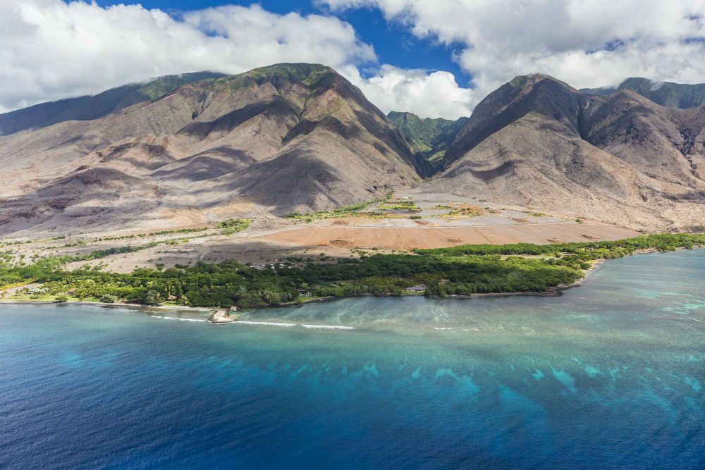
Drift, shmrift. Drift makes watching grass grow seem like an extreme sport. I thought you were in a hurry! You want a big mountain fast, you want a volcano.

Haleakala qualifies as big at 10,000 feet. Add on the 19,680 feet concealed under the ocean and you have your 30,000 foot mountain. Haleakala is less than a million years old. Mauna Loa is taller at 13,600 feet and younger: 0.1 to 0.5 million years old. These are not some puny piles of soot either - they are massive mountains full of earth power you can feel through your feet with shoes on.

Volcano ages from https://www.soest.hawaii.edu/GG/ASK/hawaii_volcano_age.html

But still; you will get old waiting for this sort of thing. Let's get on with the mountains already.

Paricutin grew from a flat place in a Mexican field to 1391 feet over 9 years. That is 154 feet / year. 30,000 feet/ 154 = 194 years to build your mountains.

That is a pretty good clip. Volcano bonuses: gouts of hot lava, flying volcanic bombs, lahar mud flows. Cherry on top: when they are erupting, green bolts of lightning strike the clouds of soot. Top that, plate tectonics.

The earth power. How can I write about Haleakala without looking at some sweet images of it? You too. enter image description here

from wendyperrin.com

$\endgroup$
5
  • $\begingroup$ The OP did say he wanted a 1000 mile long mountain chain. $\endgroup$
    – kingledion
    Commented May 15, 2017 at 11:47
  • $\begingroup$ @kingdelion I knew someone would come with that. The Hawaiian Islands are a 1500 mile mountain chain. Only the high parts are above the water. link! $\endgroup$
    – Willk
    Commented May 15, 2017 at 20:46
  • 1
    $\begingroup$ I bet you didn't know this, but if the Hawaiian hotspot was on land, it would not have formed a long chain. The cooling ability of the seawater prevents a full flood of lava coming out, making the hotspot last for millions of years as the plate over the top of it moves, causing a long chain of islands. On land, the lava all comes out at once until the pressure/temperature drops in the mantle hotspot and the vulcanism stops. Check out the Tibesti mountains in Chad for what a hotspot looks like on land. $\endgroup$
    – kingledion
    Commented May 15, 2017 at 22:02
  • $\begingroup$ I knew Hawaii was from a moving hotspot but I did not know that it was the backpressure from seawater that caused it to last. Good stuff! How about the Cascades then? They are a mountain chain of volcanoes... mostly. Also young. $\endgroup$
    – Willk
    Commented May 17, 2017 at 14:38
  • $\begingroup$ The Cascades are a subduction zone at a plate boundary. Almost all the long chain mountains are. In the early stages of subduction you get lots of volcanoes (Cascades, Aleutians, Japan, Phillipines). In the later stages you get huge but less volcanic (Alps, Himalayas). $\endgroup$
    – kingledion
    Commented May 17, 2017 at 14:58
4
$\begingroup$

An article published in the June 15th issue of Earth and Planetary Science Letters suggests that the Tibetan plateau may have risen much more rapidly than previously thought. Similar to the Andean plateau, most people believe the Tibetan plateau rose to its present elevation over tens of millions of years, but this study suggests that much of that elevation may have developed over the past two to three million years. source

Fastest known is two million years. To half that, you'll have to look at that range and double the conditions there--if you are going with plate movement as a source.

But may I suggest, for the quickest of mountains, using volcanic activity instead, a la Paricutin.

There are plenty of examples of islands being formed: 10 in the last 20 years. These "islands" are actually mountains rising up from the sea bed, sometimes in as little as a year.

Now, volcanic activity is due to plate movement in a lot of cases, so technically, all you would need is a chain of them being formed in order to get your mountain range. In this case, they grow at an astounding rate--some in as little as a year--a lot less than your one million years.

$\endgroup$

You must log in to answer this question.

Not the answer you're looking for? Browse other questions tagged .