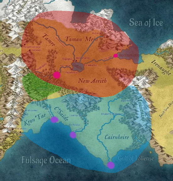
I'm creating a continent for a story I'm developing. I was just wondering if this map looked realistic from a geographical point of view (weather, city placement, environment, etc.)? Thanks for any help you can offer!
-
1$\begingroup$ Welcome to worldbuilding. How do you expect us to evaluate the geopolitical aspect? it is based on arbitrary decisions and agreement. Just look at how state borders danced across the map over the centuries. $\endgroup$– L.Dutch ♦Commented Mar 29, 2022 at 15:44
-
2$\begingroup$ Do you know the continent's size, roughly? Even if not for us, distance will be important for you later :). $\endgroup$– Tortliena - inactiveCommented Mar 29, 2022 at 15:57
-
1$\begingroup$ VTC as needing focus: OP needs to provide criteria for judging and seems to be fishing for feedback. Could also be VTC:Opinion. $\endgroup$– rekCommented Mar 29, 2022 at 22:46
-
1$\begingroup$ Since you are asking about city placement, what's the technology level? Where cities exist on that map will depend on the type of transportation available and technology to drill deep wells, keep people warm, etc. For example, a "Star Trek like" civilization that is recently settling this continent may not place cities on the coast/rivers, because they have ways to acquire water and aren't using the waterways for transportation. On the other hand, an age of exploration civilization will need to place cities in areas that they can easily access for trade with close access to resources. $\endgroup$– kuhlCommented Mar 30, 2022 at 2:29
-
2$\begingroup$ OP has yet to modify the question and seems happy to take any and all feedback, so why was this reopened? $\endgroup$– rekCommented Mar 31, 2022 at 15:03
4 Answers
Not sure about the towns
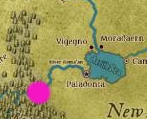
This guy is in the middle of nowhere. It should have at least a river as a source of fresh water. Even then that doesn't justify having a large city here, even if there was a resource cite here, like an iron mine. There is no way to transport that resource anywhere nearby.
Xavon Wrentaile suggests Far Reach might be an import site. If there is another land to the West, with exotic goods in demand in Tomein and New Aerith, then Far Reach is the ideal place to import them. You have to take the goods through the mountain pass, so might as well land your boats as close to the pass as possible. There are still difficulties:
(a) Lack of fresh water for drinking and farming. Might not be as much a problem if the sea brings a lot of rain for the plants, and you can build wells. Feel free to add a river to a map to remove any confusion. It would help if the river went through the mountain pass as then trade caravans can use it for drinking.
(b) Bad transport links. The only way to bring goods to Tomein and New Aerith is walking. So I suggest the imported goods have a high cost/weight ratio. For example these yummy guys:

This guy is also in the middle of nowhere.
Why do people live here? It would make sense if they mined something in the mountains, and there was a river connecting it to the cities to the southwest.
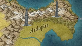
These guys look like military outposts. So the lack of water or transport is not so much an issue since they don't have many people living there.
Perhaps the fortresses were built to guard the spice trading route from Far Reach? Spices are prime targets for bandits since the high cost/weight ratio makes it easier to steal spices than iron ore.
These guys are good. I wonder what is the political situation since they all live on the same lake?
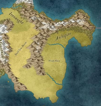
It makes sense that no one lives here. There are two places for towns at the estuaries. But they would be small since there is no large source of wood. I also figure the "Windy Plains" is battered by coastal winds and it is hard to grow stuff. This makes the sea rougher than the Southern oceans, which are sheltered by peninsulas. So it would be hard to trade with Carnheire -- still far away -- by boat. Trading by land is a no no since the Eastern coast is isolated from the rest of the continent by two mountain ranges.
Maybe chuck a few Wizard Towers down here.
The location is remote so no one will bother the wizards. Of course the towers are invisible so do not appear on normal maps.
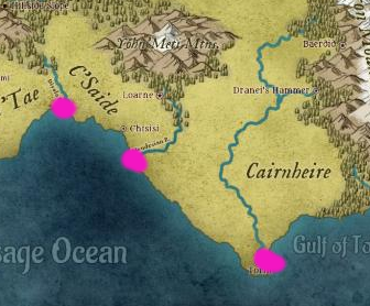
I'd expect three cities here. They can trade with each other using boats. The one on the left might have mines in the northern mountains which are conveniently close. Send the ore down the river and then maybe to the other two cities.
Same for this place. Good place for a city.
Think about putting a town here. This is where their wood comes from.
Maybe put these guys closer to the forests to make clear their main industry is logging.
Politically I'd expect two main powers:
The red guys and blue guys both have their own sources of metals and wood. So they can be independent of each other. The green guys are their own place because the forests are hard to walk through.
-
5$\begingroup$ I was going to give my own answer, but you've summed up most of the points I was going to cover, so I'll give some additional insights in here. The climate feels a little arbitrary. The snow line in the north would only make sense in a big island (like Australia), and with the addition of cold wind currents. The desert is surprisingly well placed, as the mountains would, in theory, prevent humidity to come with winds. The rivers all make sense, and all in all, is a good starting map! $\endgroup$– th0bardCommented Mar 29, 2022 at 20:16
-
1$\begingroup$ And one small addition from me: the river in Cairnheire's path to the ocean doesn't really make sense. It should either be parallel to the river south of C'Saide, or it should drain to the curve of the Gulf of Tollense. It makes no sense for the river to follow a cape to the end. $\endgroup$ Commented Mar 30, 2022 at 4:41
-
2$\begingroup$ 'I think it makes sense that no one lives here. There is no water and trade links are bad.' I disagree with this. It's much easier to move things by sea than by land. There should be a town anywhere a river meets the sea. $\endgroup$ Commented Mar 30, 2022 at 7:41
-
1
-
1$\begingroup$ @th0bard I have paid no attention to the snow line. I am happy to accept it is artistic license by whoever drew the map in-universe. $\endgroup$– DaronCommented Mar 30, 2022 at 22:45
I don't get many of your city placements.
Cities tend to grow for a reason and they need good natural supplies; typically including some non-salt water in the form of a lake or river, food (fish or hunting), and in strategic locations. That is why they line rivers and coasts, and are seldom isolated inland without at least a lake.
One strategic reason is a port in friendly seas; I'd expect a large town on that river that flows through a forest into the southern gulf; that's a trifecta of food sources, fresh water, and travel by boat on the river or sea, it would probably be largest city in this world.
There's another on the west side, south, a little gulf with a calm inlet near a forest and lake.
Natural features are what tend to define trade routes and where people live. You don't seem to be exploiting them much.
You do have towns around the big lake, but you'd likely have towns and farms just lining all these rivers, that's where the arable land is, and rivers provide drinkable water, fish, plenty of water for bathing and washing stuff, and human waste disposal (don't forget that). They also may supply underground water for wells; those aren't everywhere.
Then because of those towns, you expect roads to form, linking them and following the river, for northbound travel. Again, travelers follow the river both with and against the flow; for the water and the hunting alongside it.
For starters your map is very beautiful. I kind of feel like I am saying: "Yeah she is pretty but her teeth are kind of crooked". If you like this map for your story, roll with it! And nice work.
Here are 2 ideas.
- Discontinuous mountain ranges. I like where your mountains continue into the ocean. It seems a little strange to me where they stop and restart with a different name, like the streets in Atlanta.
The plate interaction that put up the mountains on one side would probably be the same plate on the other side. I like to think you have the low place between for story reasons. Maybe have there be a mountain pass?
- Rivers.
A lot of your rivers fall off the side of the land like they were falling off a cliff.
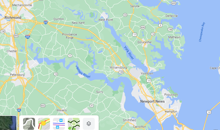
Think of why the river is where it is. That is the lowest land. And the river is going to make it lower. The ocean will probably come in to meet it because that is the low point of the land. Take a look at the rivers that empty into the Chesapeake bay.
If you look at river mouths on Google maps you will find they are all like that. Your continent has glaciers too which might have left fjords in times past. Fjords!
Have the ocean come in to meet your rivers and spread them out. Places like that are good sites for a city too - a nice river for water, access to the ocean for trade and listening to mermaids, but set back with some shelter from storms.
-
2$\begingroup$ Maybe the two gaps in the mountain range should line up with each other, like they were made by the same glacier, or the same very large centipede. $\endgroup$– DaronCommented Mar 29, 2022 at 18:23
-
2$\begingroup$ The mountains was the first thing that looked off to me too. Too many discontinuous ranges so close together. $\endgroup$– DKNguyenCommented Mar 29, 2022 at 22:47
-
$\begingroup$ @DKNguyen the other option for discontinuous mountain ranges in a line would be a Yellowstone-esque supervolcano that literally blasts the whole mountain range away in a section. Would also make for an interesting environment on one end of the line, since you’d have a similar active volcanism & geyser situation like Yellowstone currently has. $\endgroup$ Commented Mar 30, 2022 at 23:08
-
$\begingroup$ For a couple real-world examples of gaps in mountain ranges, look at the Snake River Valley (cuts most of the way through the Rocky Mountains) and the Columbia Gorge (cuts all the way through the Cascades). $\endgroup$– MarkCommented Apr 2, 2022 at 0:17
A few things that caught my eye:
The Faich'iem desert is stuck between two mountain ranges that are snow covered, so they will produce melt water in spring, which will need to flow somewhere. So there should be a river flowing there somewhere.
The whole scale of the map looks off if you want it to be a realistic continent on a twin earth planet. It looks similar to maps you'll often find accompanying fictional stories, but those are generally not too realistic either. Maybe you can include a scale to indicate how large you would like your continent to be? If I go by the density of forests and cities, this would not be a continent but rather an island, but that wouldn't realistically accommodate that many mountain ranges if those are supposed to be real mountains of several km high, and not more like hills. Also you wouldn't have a snow line on an island scale map, the area that is snow covered and frozen would change with the season, and you wouldn't find so many cities so near the edge of the permafrost.
If you want this to be a real continent, several thousand km across, then the scales of the forests, cities and rivers are off. On a true continent scale you wouldn't see individual forests on a map because they would be just dark green spots, and they would be spread out everywhere. There would also be a lot more cities, assuming a medieval Europe population density. And there would be a lot more rivers large enough to navigate. The mountains still don't look very realistic on such a scale. In reality mountain/plain is usually not binary, often a mountain range is adjacent to hilly landscape, and once you get far away enough you will have plains. With this many mountain ranges relatively close together, the 'plains' in between wouldn't be very flat, but quite rough and hilly. Although that may be what you want.


