Is there any current (or extrapolated) scanning technology that would be able to scan for deposits in a planetary crust through 16 meters of ice and LOX
There are three important things here.
Any information about the permeability of solid nitrogen or liquid oxygen to conventional ground penetrating radar techniques is either very hard to come by, or entirely absent.
This shoudln't come as a surprise... there's not an awful lot of it about, and the places where you can find a lot of nitrogen ice are extremely hard to get to (eg. Pluto) and as such there's so much else to investigate first that things to look under the layers of unusual (by our standards) ice don't seem to get a lot of obvious press.
Conventional aerial prospecting techniques already have to look through an awful lot more material than that, because anything that's just lying around in the to 16m of landscape is probably going to be exposed by a watercourse somewhere and will be relatively straightfoward to find.
If you can find where to mine on Earth using a satellite or aircraft, it should be fine on your world, even under quite generous layers of ice.
No "scanning" is ever quick or easy. It requires plenty of time to complete the "scan", then plenty of computer and human time to interpret the results. On an alien world, the results may not even be readily interpretable, depending on how weird and exotic the geology of the world is compared to those already studied by the people doing the scanning.
Peeking with a satellite is no substitute for bots on the ground. And no, I didn't mean "boots". The best kinds of geophysical "scans" involve having your sensors directly coupled to the ground, and until you go down and get your bots dirty you'll only have vague ideas. Orbital scans tell you where you should do low-altitude aerial scans, and those will tell you where to put equipment on the surface, and that will tell you where to make investigatory boreholes and so on.
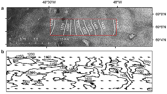
Now although the earlier requirements to look through a mile of ice have since been removed, but I'll mention this anyway: Radar images of the bed of the Greenland Ice Sheet.

This is a synthetic aperture radar image assembled from scans by RADARSAT-1, a satellite which was launched in 1995, to give you an idea of how cutting edge this stuff is. The top image is the terrain of Greenland, and the lower contour map shows the depth of ice in metres above it.
Clearly it is possible to see through that much water ice (because I don't know if anyone knows if you can see through nitrogen ice this way... it seems likely but isn't guaranteed) and observe the terrain underneath, but that's all you'll be able to see. Smooshed subglacial terrain may be able to tell you something of interest (such as interesting signs of habitation or industry on the planet before it was ejected) but it won't tell you what sort of minerals might be available.
Next up might be magnetotellurics, a way of detecting disturbances in the planetary electrical or magnetic fields and using these to form a picture of subsurface structures. Though this is usually done on the surface (here's a plan to use this technique on a lander: A magnetotelluric instrument for probing the interiors of Europa and other worlds) characterisation of large scale geological features might be possible. Real world present day companies exist which use aircraft mounted magnetic and electrical field sensors demonstrating that contact with the ground is not essential for some survey work.
Resolution from orbit seems likely to be low, but might help identify regions of potential interest.
Gravimetry is the measurement of differences in gravitational field strength. It can certainly be done from orbit... the GRAIL satellites around the Moon and the GRACE satellites around the Earth performed detailed mapping of gravitational anomalies of the bodies they orbited, and this information will also be useful in establishing a baseline geological knowledge, identifying big and interesting masses in the crust of the planet and working out where to visit for more detailed investigation.
Finally, I'm gonna suggest reflection seismography. This is a modern-day geophysical exploration technique that you wouldn't expect to be able to use from orbit but:
- you have a scifi spaceship capable of distant interplanetary or maybe even interstellar travel.
- you are working on a planet with no atmosphere.
You clearly have power to spare and there's nothing in your way.
Use LIDAR and related laser surveying devices to give you a good high-resolution view of the planet's surface, then get blasting. If it makes you feel better, you can class your orbital bombardment laser cannon as entirely peaceful surveying equipment... a kind of high-power LIDAR illuminator, if you will. You can carefully control the energy output, and use your "scanning" lasers to carefully measure refected seismic waves to plot underlying terrain shapes and geological features.
Unlike the passive investigation methods above, this very focussed probing can give you potentially quite high resolution subsurface imaging, and an excellent idea of what materials are actually down there, even from several hundred kilometres away (as you might expect to be, in a spacecraft).
Without some decent understanding of geology, interpreting the output of the laser seismometers will be challenging... this isn't a tricorder-like "bleep bloop dig here for uranium", but with sufficiently clever minds analysing the data you should be able to draw parallels with known geological features on other worlds and start making plans for a more hands-on investigation.
And lest you think this is purely scifi from someone known to have unreasonable opinions about lasers, I give you Seismology on small planetary bodies by orbital laser Doppler vibrometry.

