6
$\begingroup$

If I've recently started a colony on a somewhat habitable, but uninhabited planet, what's the best way to determine the location of any ore or other subterranean resource deposits?

The planet is Earth-sized and of similar composition. It's a similar distance from a similar star, but much younger. Temperature-wise, it would be habitable, but life on the planet is still mostly composed of bacteria-like anaerobes and there's insufficient oxygen for humans to survive outside without supplemental oxygen tanks.

The settlers have access to near-future technology and have ample time to research and test the planet before going there. They've got plenty of funding for rovers and satellites and can deploy a large number of each. They'd like to establish a long-term settlement on the planet, and as such, they need to locate suitable reserves of construction and manufacturing materials like titanium, gold, and rare earth metals.

What's the simplest and quickest way for the settlers to accurately survey their new planet? What sort of technology that's feasible in a near-future setting would need to be developed in order for them to properly survey their new home?

$\endgroup$
5
  • 3
    $\begingroup$ Related: earthscience.stackexchange.com/questions/4848/… $\endgroup$
    – kingledion
    Commented Dec 5, 2016 at 19:20
  • $\begingroup$ Obligatory comment: Why aren't they mining the asteroids and moons instead? Titanium, etc are all in ample supply, and I assume they can spend some amount of time in orbit, since the planet itself isn't suitable for life without terraforming. $\endgroup$
    – John Feltz
    Commented Dec 5, 2016 at 20:17
  • $\begingroup$ You need remote-sensing satellites and a couple of geologists assisting your settlers. $\endgroup$
    – a4android
    Commented Dec 6, 2016 at 5:42
  • 1
    $\begingroup$ Keep in mind you don't need to find anything deep on a uninhabited planet there will be plenty of surface deposits. On earth there are almost none becasue they have been mined out by humans already. $\endgroup$
    – John
    Commented Dec 6, 2016 at 16:11
  • $\begingroup$ related but not duplicate: worldbuilding.stackexchange.com/questions/47203/… $\endgroup$ Commented Dec 6, 2016 at 18:20

3 Answers 3

3
$\begingroup$

Gamma-Ray Spectroscopy

One newly developed technology, gamma-ray spectroscopy, is supposedly capable of doing just what you want. This is a new technology just recently developed, and is being publicized as destined for future asteroid mining by companies like Planetary Resources:

The technological development is a new generation of gamma-ray spectroscope that appears perfectly suited for detecting veins of gold, platinum, rare earths and other valuable material hidden within the asteroids, moons and other airless objects floating around the solar system – just the type of “sensor” that will be needed by asteroid miners to sniff out these valuable materials.

If atmospheres interfere too much with naturally occurring gamma rays, perhaps man-made mobile gamma ray generators could be used used with spectroscopes.

Spectroscopy Using Other Wavelengths

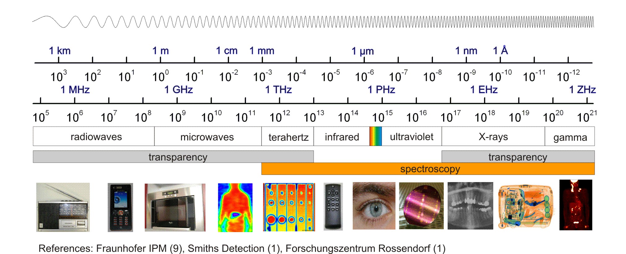
I imagine spectroscopy of this type will expand in capability as technology evolves and need increases. Terahertz spectroscopy is being developed quite a lot recently, and I'd expect science will attempt to harness every conceivable wavelength as much as possible.

enter image description here

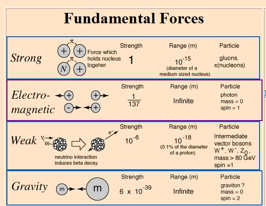
Currently, science has a fairly good working knowledge of the electromagnetic spectrum, and I imagine as more knowledge of other fundamental fields (such as gravity) becomes better understood, that knowledge will be applied to this problem as quickly as possible.

enter image description here

Since every element has it's own unique weight, perhaps something like gravitational spectroscopy could one day be a possibility.

$\endgroup$
3
  • $\begingroup$ Precision measurements of gravity are already used for locating underground caverns, aquifers and oil reservoirs as those areas have lower specific density than other parts of the mantle and thus a slightly lower gravitational pull above them. $\endgroup$
    – ohwilleke
    Commented Dec 6, 2016 at 1:19
  • $\begingroup$ If you have people carrying around the things it is far easier to just do normal geology (aka a hammer). but a satellite mapping and imaging would indeed be a great help, it would also have several side benefits, mapping, communication, ect. $\endgroup$
    – John
    Commented Dec 6, 2016 at 15:55
  • $\begingroup$ remember on a newly colonized planet there will be plenty of surface deposits unlike the earth. you don't need to look deep even a simple normal image satellite will be a massive help in locating resources. $\endgroup$
    – John
    Commented Dec 6, 2016 at 16:02
3
$\begingroup$

We can already do this without paying for new tech

While developing newer technologies may work (as cited in other answers) the development of technology is costly - and for a mission which will already cost billions, why not use what's proven to work instead?

Take a look at the Mars Reconnaissance Orbiter (MRO)

It can take care of everything your question describes, in detail.

Location of Surface Minerals: See the Compact Reconnaissance Imaging Spectrometer for Mars (CRISM)
This instrument searches for specific surface minerals in 18 meter-wide areas - more than small enough for rovers and subsequent colonists to visit and confirm.

Composition and Layout of Terrain: See High Resolution Imaging Science Experiment (HiRise)
This instrument can also identify groups of minerals in areas as small as 1 meter - extreme detail - as well as show what terrain looks like, which will help your miners figure out if they should, and how they will, get there.

Deeper Deposits: See Shallow Radar (SHARAD)
This instrument observes features up to a kilometer underground, and is sensitive to the characteristics of specific substances.


In summary, there is no point in developing or investing in other technology. If this mission will cost as much as it appears, you should just use what's proven to work.

$\endgroup$
2
$\begingroup$

When doing this on earth, there are a variety of techniques:

Techniques possible from space:

A: Aerial photography. Several of the world's big iron and nickel deposits are associated with very old meteor strikes. (Sudbury Nickle deposit is the big one I know of.)

B: Gravity anomalies. A metal deposit is more dense than the surrounding rock. A big deposit creates a slight irregularity in the gravitational field. These can highlight areas that merit closer attention.

C: Magnetic anomolies. Works only for some types of iron ores.

Techniques from the surface:

The problem with surface checks is manpower. But given reasonably sophisticated drone technology, it should be reasonable to send out a swarm of drones, that do spot checks on exposed rock, zapping it with a moderate power laser and reading the spectrum from the plasma.

Drone tech also can fine tune the gravity and magnetic anomalies.

If you are at a level of just unicellular organisms however, you may be somewhat handicapped. Read up on ore body formation. Good number of theories involve activity by microbes to create the ore body.

$\endgroup$
1
  • $\begingroup$ manpower is not too big a problem, one person can check a vast area if they have satellite support. drones are really slow and really bad at rocky and steep terrain, the very terrain you will be searching most often. And microbes form some types of ore, others form for completely abiotic reasons. $\endgroup$
    – John
    Commented Dec 6, 2016 at 16:08

You must log in to answer this question.

Not the answer you're looking for? Browse other questions tagged .