5
$\begingroup$

map

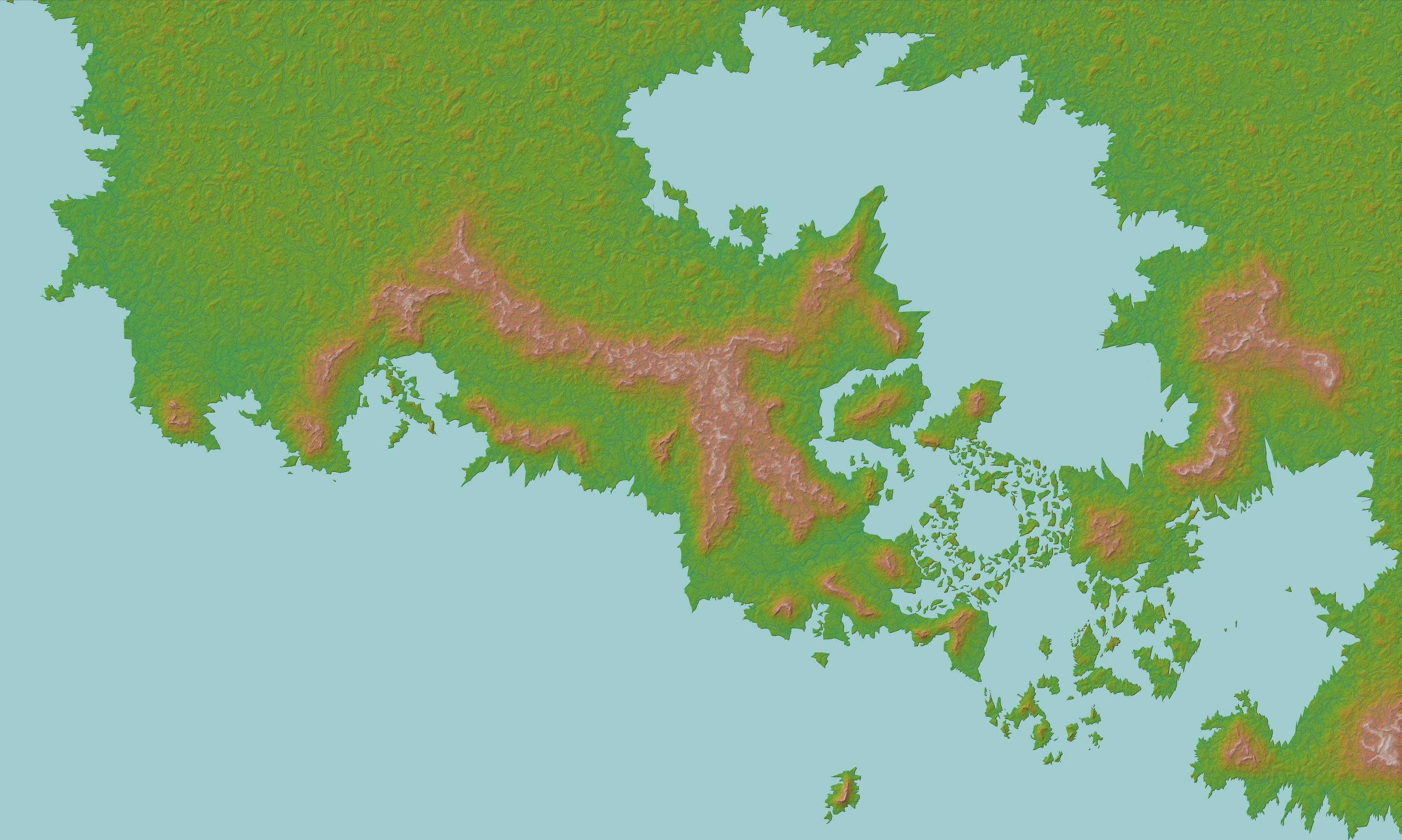
I created the above map using Photoshop and used Wilbur to erode the terrain a bit and calculate possible river flows. Still needs work but I need to create a river mask before I can go on. My method at the moment is to trim down the generated river flows to just the ones I want to keep, but I'm having trouble deciding how many rivers I should place and where they should be.

The scale of the map is roughly 1px=1km. It seems to me then that only rivers with an average width of >1km should be depicted. However, I'm mostly using the map as a reference for worldbuilding and writing purposes, so I'd be losing a lot of meaningful detail by not including smaller but still significant rivers. It's also difficult for me to realistically determine how wide/big each river would be, and factors like tributaries and how far they appear into the mountain ranges just makes it even more complicated. I'd imagine things like amount of precipitation at each catchment area would also need to be considered.

The map isn't based on an Earth-like world so a lot of geological factors like tectonics and latitude don't translate directly. Without getting too far into the weeds, I'd just like to find a decent methodology to get a reasonable river mask finished. Any suggestions would be appreciated.

$\endgroup$
9
  • $\begingroup$ Possible Duplicate:worldbuilding.stackexchange.com/questions/21402/… $\endgroup$
    – Devon M
    Commented May 1, 2018 at 6:52
  • $\begingroup$ I don't think that other thread addresses the specifics of my question $\endgroup$
    – Akirus
    Commented May 1, 2018 at 7:00
  • $\begingroup$ Do you own any real maps? $\endgroup$
    – dot_Sp0T
    Commented May 1, 2018 at 9:05
  • $\begingroup$ Do Google Maps count? $\endgroup$
    – Akirus
    Commented May 1, 2018 at 9:35
  • $\begingroup$ But isn't there an option in Wilbur to add rivers? Also, did you know that a new version as been released not long ago? $\endgroup$
    – Vincent
    Commented May 1, 2018 at 14:26

3 Answers 3

7
$\begingroup$

I'm also drawing a map like yours... I find it usefull to have at least 2 river layers :

  • one with the most important rivers and a few tributaries that you can use on a global map ;

  • one with many smaller rivers that you can use for local maps.

This is important to keep only the major features on your global map. If you add too many details, the map will be hard to read. When the map is done, you need to be able to spot right away the elements that shape the land at a continental scale.

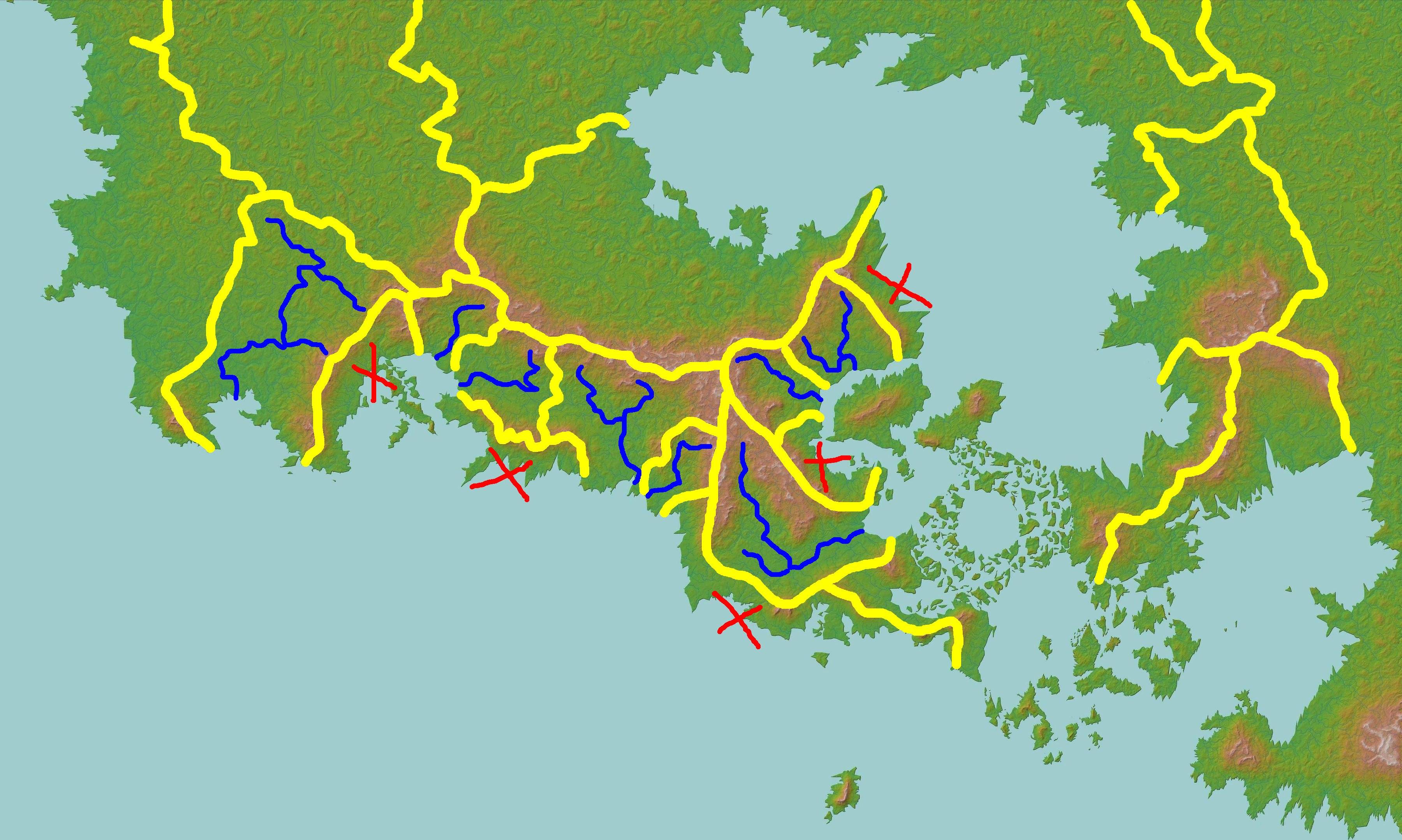
To decide what will be your biggest rivers, it may be usefull to draw the drainage basins (watersheds). Draw the limits of your watersheds along topographical ridges. I've done a quick edit on your map to show you as an example :

Map with drainage basins (quickly done)

The yellow lines are the watershed limits (roughly). Draw it on a new layer, that you can hide later. I started along the mountain crest, and between rivers that flow toward different directions. Once I've made a few significant areas, I tried to add the major river in it.

Watersheds that are just a coastal band should not have major rivers, that's why I've put red crosses on it. This is where you should add rivers only on a local map.

When the watershed was big enough, I added a river, starting from the river mouth and then trying to find a way to the mountains. I added a few tributaries in the larger watersheds, to fill the voids.

As you can see, it's just a start. I haven't filled the biggest watersheds. You may need to subdivide them. I hope it gets you started anyway.

To get an idea of the number of rivers you should have on your map, just compare to a real map that you like, at the same scale (with roughly same climate). Even if your planet is different from Earth, it's not a problem. There is no "true map". What truly defines a map is not the planet, but the target reader. Maps are always based on choices, a balance made by the geographer to set the right amount of information, and make the map usefull and easy to read.

$\endgroup$
5
  • $\begingroup$ Very helpful, thank you. How would you classify the rivers on the larger islands when drawn next to a continent using your method? Would you just draw them on the small river layer? puu.sh/AdSkQ/c98ea891b1.jpg What about something like the converging river between the two mountains on the right hand island in the screenshot? For reference, it's around 200,000 sqkm in area. $\endgroup$
    – Akirus
    Commented May 1, 2018 at 9:55
  • 1
    $\begingroup$ It depends on what other informations you want to put on those islands. On the global map, they appear pretty small. If you have major cities on those islands, this is what you should show. Rivers may add to much information. I would display them on the local layer. $\endgroup$
    – Ghajini
    Commented May 1, 2018 at 10:13
  • $\begingroup$ What do the red Xs represent? $\endgroup$
    – Willk
    Commented May 1, 2018 at 13:20
  • $\begingroup$ Drainage basins without major rivers $\endgroup$
    – Akirus
    Commented May 1, 2018 at 15:07
  • $\begingroup$ That's it. When the mountain ridge is close to the sea, the river source is close to its mouth. So you'll have many short rivers flowing directly to the sea, as they don't have enough space to converge into a bigger one. $\endgroup$
    – Ghajini
    Commented May 1, 2018 at 22:04
2
$\begingroup$

Map showing roads drawn over scale

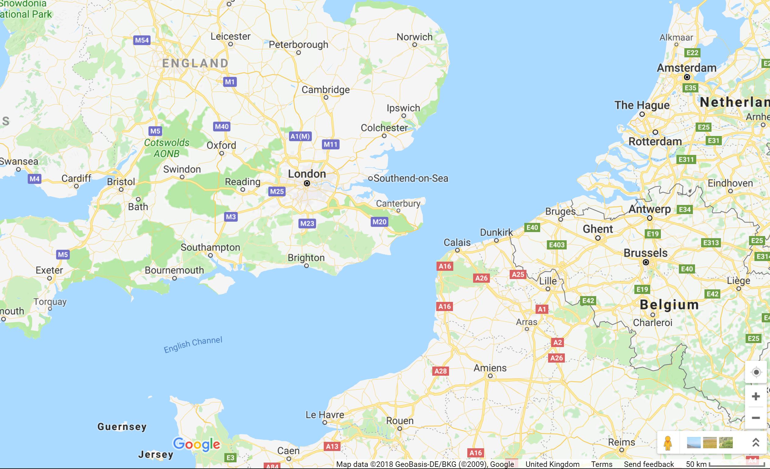
Here's a map of some of the UK. France, the Netherlands and Belgium. In the right hand corner you can see the scale, and all over the map you can see major roads. I'm going to go out on a limb and suggest that none of the roads that you can see on the map are actually a kilometre or more wide.

The point I'm (somewhat facetiously) making is that maps are never a truly accurate representation of the world - they can't be. Instead, they're a representation of those features deemed important to their creators, and so choose what to emphasise and what to play down or omit entirely.

Because of this there's no guarantee of scale - if your map needs rivers (as you said, omitting them would lose a lot of meaningful detail), then include them at as close to their actual scale as possible, making them larger than scale as necessary.

$\endgroup$
3
  • $\begingroup$ I agree with you, but my main problem is deciding what scale of river should be deemed important; I've been agonizing about it for days and haven't figured out the approach I want to take yet. The Wilbur render gives a huge number of rivers that I'm trying to narrow down and it's driving me mad deciding what to keep and hide. I considered and dismissed the idea of drawing it to scale pretty quickly for the reason you stated. Beyond that, I'm at a loss as to how to determine what a meaningful size cutoff for a river would be, and how to even assign a scale to each river on the render. $\endgroup$
    – Akirus
    Commented May 1, 2018 at 9:00
  • $\begingroup$ Hmm, do you have any other heuristics you can use to narrow it down? I can't really answer for you at what point a river becomes important enough to map, but you could try splitting the rivers into two or more arbitrary categories (E.G. 'big' and 'small'), and putting each type onto different layers to help you visualise. $\endgroup$
    – walrus
    Commented May 1, 2018 at 9:04
  • 1
    $\begingroup$ It may be hard to see since I had to lower the quality of the image a lot to post it on imgur, but I actually have two different Wilbur river renders of different river lengths. The second render shows as different coloured extensions of the first. I've been using that to try to determine the 'big' rivers' but Wilbur still renders everything 1px wide so it's hard to tell still. I'll try Ghajini's approach using drainage basins and see how it goes. $\endgroup$
    – Akirus
    Commented May 1, 2018 at 9:34
0
$\begingroup$

Sorry for this but I don't have enough reputation to comment but here is my recommendation.

Take some time to think about the cultural and geographical significance of the rivers and draw the important ones on. E.g. How the Nile allowed the Egyptians to thrive and adds green to Africa and how the Rhine allowed the Germanic people to trade better.

$\endgroup$

You must log in to answer this question.

Not the answer you're looking for? Browse other questions tagged .