7
$\begingroup$

I'm new here but I've been a worldbuilder for the last decade or so. I'm pretty late to the 'mapping out your country' party and I've only been at it for about 8 months, but I'm starting to see some progress.

However, I appear to have a bit of a deficiency in my knowledge of rivers that threatens to jeopardize the realism of the whole project.

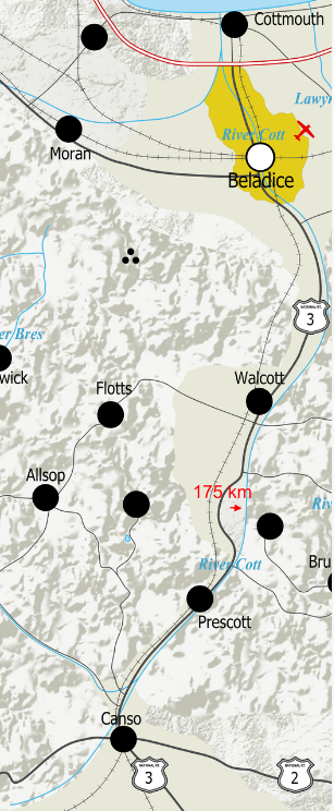
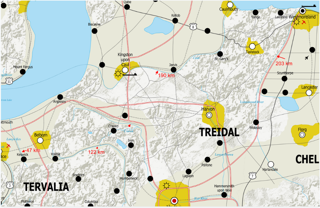
I'm attaching a few examples (in these screen grabs the effects that you see in the above map are off, so everything looks a bit crude, bear with me) of rivers that in particular stand out as ones that don't look right, along with distance measurements of what you see on-screen, to give you a sense of the scale I'm working with.
enter image description here(also here)

enter image description here(also here)

Nothing you make is ever truly finished, so with that in mind there is very little in the country that I am 100% married to, but if I'm going to have to redraw the rivers again, this time I'd like to get it right.

With that in mind, I wanted to ask: what principles I should bear in mind when drawing rivers? Obviously I have a basic grasp of the fundamentals (water flows downhill down the steepest slope possible, rivers merge, not split, etc etc) but my knowledge is pretty lacking beyond that

Thank you for any and all assistance that you may be able to give me!

$\endgroup$
6

4 Answers 4

8
$\begingroup$

Some incomplete rules:

  • The faster water is flowing, the less likely it is to turn: Flat land means winding rivers.
  • Rocky land means more turns.
  • When water slows down, it loses any silt it is carrying, and it can wind, or even split, as it does at the Danube delta.
  • Water may pool if it cannot immediately get through, but it almost always finds a way to the sea, or at least into an endorheic basin, such as the Dead Sea.
  • Rivers often converge: two rivers form one.
  • While relatively rare, rivers can diverge: one river forms two.
$\endgroup$
4
  • 1
    $\begingroup$ "Almost always finds a way to the sea": this is utterly false. Eurasia has absolutely huge endorheic basins. The longest river in Europe is the Volga, which flows into the Caspian, as does the Ural river. The Amu Darya and the Syr Darya (the Oxus and Jaxartes of the ancients) flow into the Aral. The Helmand and the Tarim rivers get lost in the desert. In Africa, the Okavango dissipates into a famous inland delta. $\endgroup$
    – AlexP
    Commented Jan 3, 2019 at 17:49
  • 2
    $\begingroup$ By "sea" I understand "point of rest". That is, river waters want to flow down until they can flow no more; the point where the river stops flowing and the waters come to rest is the sea. An endorheic basin is just a metaphorical sea. And the Dead Sea just happens to be a sea at the bottom of an endorheic basin. $\endgroup$
    – elemtilas
    Commented Jan 3, 2019 at 17:59
  • 1
    $\begingroup$ @elemtilas Interesting twist on the Scotsman fallacy. Including more and more into the word "sea" until it means whatever you want it to mean. $\endgroup$
    – pipe
    Commented Jan 4, 2019 at 17:36
  • 4
    $\begingroup$ @pipe --- Not really a fallacy: rivers always flow from high elevation to low, until they can go no lower. The Danube begins in the Alps somewhere and ends up in the Black Sea. The Jordan starts up in the Golan and flows even lower than the Danube, down into one of those endorheic basins. Whether there is an actual sea or a theoretical one is really neither here nor there. Any rate, the Tarim Basin was once part of the Paratethys Sea, so, no true Scotsman need get his kilts in a twist! $\endgroup$
    – elemtilas
    Commented Jan 4, 2019 at 22:45
2
$\begingroup$

I see that your rivers have a tendency to flow along the foot of your mountains. This is not very realistic, in real geography rivers tend to be in the middle of a plain, maybe meandering, maybe straight. Straight rivers come either from a fast flow caused by a strong height difference or from regulation by human activity (the landscape looks industrialised, so river regulation probably happened).

The course of the Lemonwood river near Wolesey looks unnatural, I'd expect it to flow east of the hills and through Florg.

There is a watershed near the number 7 on your map: West of it the river flows northward, East of it a river flows southward. This can happen, but it is a remarkable geographic feature in itself. When the rivers are navigable, people may build a canal across this watershed.

I assume that Avon Lake has a higher level than the lake/sea at Caulmouth, so it is not directly connected to that part except by river Caul.

BTW, the placement of some of the big cities in the mountains also looks suspicious and calls for an internal historical explanation.

$\endgroup$
5
  • $\begingroup$ The flowing of rivers among the mountains was heavily inspired by the Hron river's path in Slovakia. It originates at the foot of a large mountain, but the valley it cuts is vast, and there are a lot of mountains very close by for about half of its total course. Further downstream it runs more centrally in a plain, but even then it does curve around quite a few mountains. Caulmouth is the location of the sea, and yes the Avon Lake is higher up. $\endgroup$
    – Andrew
    Commented Jan 5, 2019 at 17:12
  • $\begingroup$ As for the rivers flowing in the opposite direction, this was based off the rivers Taw and Exe in England. Relatively close to each other, but flowing in separate directions. Which cities are you referring to when referring to suspicious placement? $\endgroup$
    – Andrew
    Commented Jan 5, 2019 at 17:12
  • $\begingroup$ The big cities in the mountains Harvon and Tavistock. Usually, big cities grow in the plains, at the rivers or at the coast. But there are exceptions, ore mines are a good reason for a city in the mountains. $\endgroup$ Commented Jan 5, 2019 at 19:21
  • $\begingroup$ Given my Slovak heritage, I have heavily let our towns influence those that exist in my worldbuilding project as well, and as such you would be correct by surmising that these are mining towns. $\endgroup$
    – Andrew
    Commented Jan 5, 2019 at 20:01
  • $\begingroup$ If the Basin-and-Range Province had enough water to form rivers, I'd expect there to be a few instances of a mountain range with rivers flowing along both sides, but that's a rather unusual geologic area. $\endgroup$
    – Mark
    Commented Jan 6, 2019 at 8:06
2
$\begingroup$

The direction of your rivers is a function of your topography and the amount of water you have flowing over it. A tiny amount of water doesn't flow because it is absorbed or evaporates; a massive amount of water is a lake or sea. The assumption must be that you are moving a moderate amount, a "river-making amount," of water across the land.

Your river starts up and heads down; Pardon the anthropomorphizing but it does not "know" where the sea is. Place your elevation changes where you want/need them to be. Figure out where your water comes from (rain, snow melt, etc.) and then let your flow choose the most direct route down. Pooling water will "choose" to flow if it has the option.

There are at least two other considerations: obstacles and ice. Your rivers will be turned by stone which is, of course, impermeable. And while ice does flow in the form of glaciers, glacier flow is an entirely different question.

$\endgroup$
2
$\begingroup$

You have two rivers, marked 190km and 203km, that flow alongside your mountains, which is very unusual, mountains mean high ground which means the land around them should be raised as well, meaning water should flow away from hte mountains not along them. Its fine when you have mountains on both sides but for those two you have mountains on one side and open plains on the other, they should flow closer to the center of the flat lands. Worse they bracket the same mountains, one or the other might be believable due to a faultline mountain with a prevailing slope to the ground but that won't work for both. 190km is especially bad since there is a lake right next to it meaning there is lower land out their. So you should either move the river or have some indication of raised land like hills between them.

As a second complaint the lake in the plains I mentioned near 190km connects to nothing, which might be believable in a lake in the center of the mountains but on hte open plains something needs to feed and drain it. So your best single move overall is to move 190km river to intercept the lake.

$\endgroup$
3
  • $\begingroup$ When you say "As a second complaint the river in the plains I mentioned near 190km connects to nothing, which might be believable in a lake in the center of the mountains but on hte open plains something needs to feed and drain it", I presume you were referring to the lake near Qube/Kellob? That one's watershed is still incomplete, I did intend to have some streams feeding into it and draining it. In your final sentence, you mean that I should move the 190 km river so that it feeds into and/or feeds out of that lake? Thanks! $\endgroup$
    – Andrew
    Commented Jan 5, 2019 at 17:17
  • $\begingroup$ that was a typo it was supposed to say the LAKE near 190km. $\endgroup$
    – John
    Commented Jan 5, 2019 at 19:54
  • $\begingroup$ Noted - I will rework the water in that area and move the river more into flatland. Thank you! $\endgroup$
    – Andrew
    Commented Jan 5, 2019 at 20:02

You must log in to answer this question.

Not the answer you're looking for? Browse other questions tagged .