added 220 characters in body
Source Link
Cyn
  • 20.4k
  • 3
  • 45
  • 89

I'm new here but I've been a worldbuilder for the last decade or so. I'm pretty late to the 'mapping out your country' party and I've only been at it for about 8 months, but I'm starting to see some progress.

However, I appear to have a bit of a deficiency in my knowledge of rivers that threatens to jeopardize the realism of the whole project.

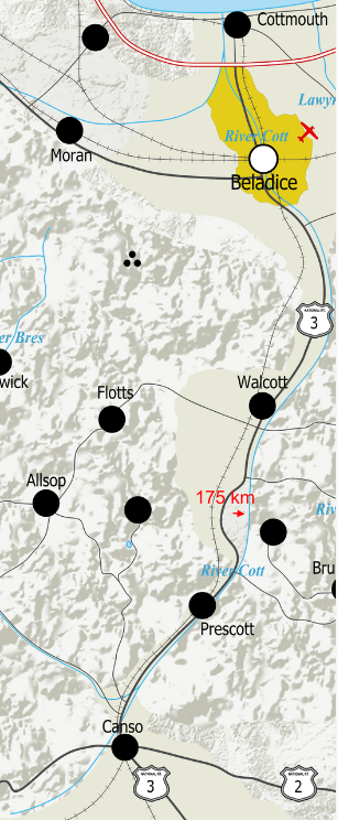
I'm attaching a few examples (in these screen grabs the effects that you see in the above map are off, so everything looks a bit crude, bear with me) of rivers that in particular stand out as ones that don't look right, along with distance measurements of what you see on-screen, to give you a sense of the scale I'm working with.

enter image description here(also https://www.dropbox.com/s/4m70lipx9wdun7m/river%20question%20a%20fixed.png?dl=0here)

enter image description here(also https://www.dropbox.com/s/fqimf8zjruf68kf/river%20question%20b.PNG?dl=0here)

Nothing you make is ever truly finished, so with that in mind there is very little in the country that I am 100% married to, but if I'm going to have to redraw the rivers again, this time I'd like to get it right.

With that in mind, I wanted to ask: what principles I should bear in mind when drawing rivers? Obviously I have a basic grasp of the fundamentals (water flows downhill down the steepest slope possible, rivers merge, not split, etc etc) but my knowledge is pretty lacking beyond that

Thank you for any and all assistance that you may be able to give me!

I'm new here but I've been a worldbuilder for the last decade or so. I'm pretty late to the 'mapping out your country' party and I've only been at it for about 8 months, but I'm starting to see some progress.

However, I appear to have a bit of a deficiency in my knowledge of rivers that threatens to jeopardize the realism of the whole project.

I'm attaching a few examples (in these screen grabs the effects that you see in the above map are off, so everything looks a bit crude, bear with me) of rivers that in particular stand out as ones that don't look right, along with distance measurements of what you see on-screen, to give you a sense of the scale I'm working with.

https://www.dropbox.com/s/4m70lipx9wdun7m/river%20question%20a%20fixed.png?dl=0

https://www.dropbox.com/s/fqimf8zjruf68kf/river%20question%20b.PNG?dl=0

Nothing you make is ever truly finished, so with that in mind there is very little in the country that I am 100% married to, but if I'm going to have to redraw the rivers again, this time I'd like to get it right.

With that in mind, I wanted to ask: what principles I should bear in mind when drawing rivers? Obviously I have a basic grasp of the fundamentals (water flows downhill down the steepest slope possible, rivers merge, not split, etc etc) but my knowledge is pretty lacking beyond that

Thank you for any and all assistance that you may be able to give me!

I'm new here but I've been a worldbuilder for the last decade or so. I'm pretty late to the 'mapping out your country' party and I've only been at it for about 8 months, but I'm starting to see some progress.

However, I appear to have a bit of a deficiency in my knowledge of rivers that threatens to jeopardize the realism of the whole project.

I'm attaching a few examples (in these screen grabs the effects that you see in the above map are off, so everything looks a bit crude, bear with me) of rivers that in particular stand out as ones that don't look right, along with distance measurements of what you see on-screen, to give you a sense of the scale I'm working with.

enter image description here(also here)

enter image description here(also here)

Nothing you make is ever truly finished, so with that in mind there is very little in the country that I am 100% married to, but if I'm going to have to redraw the rivers again, this time I'd like to get it right.

With that in mind, I wanted to ask: what principles I should bear in mind when drawing rivers? Obviously I have a basic grasp of the fundamentals (water flows downhill down the steepest slope possible, rivers merge, not split, etc etc) but my knowledge is pretty lacking beyond that

Thank you for any and all assistance that you may be able to give me!

deleted 1346 characters in body
Source Link
Andrew
  • 153
  • 5

I'm new here but I've been a worldbuilder for the last decade or so. I'm pretty late to the 'mapping out your country' party and I've only been at it for about 8 months, but I'm starting to see some progress. If anyone would like to see the map as it stands right now, I've attached a link here:

https://www.dropbox.com/s/9k0og377e9ub3zo/Yorkland%20January%202019.PNG?dl=0

The country is based heavily off of my homeland of Slovakia, and with that in mind I went slightly overboard with the mountains, although not to a degree that would heavily affect the economy of the island, provided that there's enough industry in the flat areas.

However, I appear to have a bit of a deficiency in my knowledge of rivers that threatens to jeopardize the realism of the whole project.

I'm attaching a few examples (in these screen grabs the effects that you see in the above map are off, so everything looks a bit crude, bear with me) of rivers that in particular stand out as ones that don't look right, along with distance measurements of what you see on-screen, to give you a sense of the scale I'm working with.

https://www.dropbox.com/s/4m70lipx9wdun7m/river%20question%20a%20fixed.png?dl=0

https://www.dropbox.com/s/fqimf8zjruf68kf/river%20question%20b.PNG?dl=0

https://www.dropbox.com/s/072sew745mqlot9/river%20question%20c%20fixed.png?dl=0

https://www.dropbox.com/s/481x88630vcp9yr/river%20question%20d.png?dl=0

Nothing you make is ever truly finished, so with that in mind there is very little in the country that I am 100% married to, but if I'm going to have to redraw the rivers again, this time I'd like to get it right.

With that in mind, a few questions from myselfI wanted to ask: what principles I should bear in mind when drawing rivers? Obviously I have a basic grasp of the fundamentals (water flows downhill down the steepest slope possible, rivers merge, not split, etc etc) but my knowledge is pretty lacking beyond that

  • how accurate are the rivers that I highlighted with the red arrows? I know for sure that some, like the Lemonwood, look more like roads than rivers and that one will have to be redrawn for sure, but is there anything that is close enough to life that I can leave it as it is?

  • what dictates whether a river is relatively straight or super curvy in a section?

  • in areas such as the mountain range sandwiched between the Caul and Lemonwood rivers in the first example I linked, which way would it make more sense for the rivers to go? Should they meander among the mountains, follow a more straightforward path in the flat areas? Or does it not really matter?

  • are there any other principles I should bear in mind when drawing rivers? Obviously I have a basic grasp of the fundamentals (water flows downhill down the steepest slope possible, rivers merge, not split, etc etc) but I'm wondering if there is anything else that I should bear in mind that I may not know about.

Thank you for any and all assistance that you may be able to give me!
I'm new here but I've been a worldbuilder for the last decade or so. I'm pretty late to the 'mapping out your country' party and I've only been at it for about 8 months, but I'm starting to see some progress. If anyone would like to see the map as it stands right now, I've attached a link here:

https://www.dropbox.com/s/9k0og377e9ub3zo/Yorkland%20January%202019.PNG?dl=0

The country is based heavily off of my homeland of Slovakia, and with that in mind I went slightly overboard with the mountains, although not to a degree that would heavily affect the economy of the island, provided that there's enough industry in the flat areas.

However, I appear to have a bit of a deficiency in my knowledge of rivers that threatens to jeopardize the realism of the whole project.

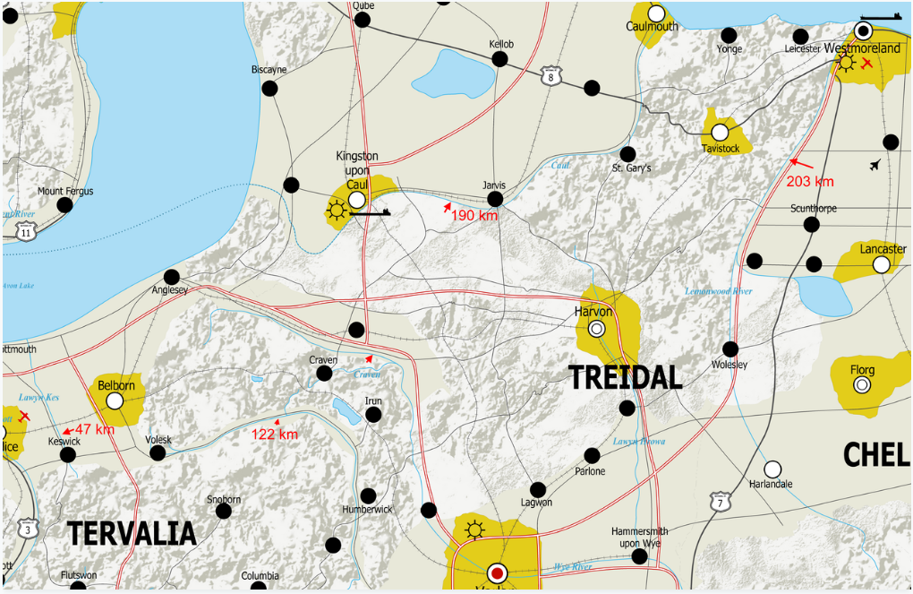
I'm attaching a few examples (in these screen grabs the effects that you see in the above map are off, so everything looks a bit crude, bear with me) of rivers that in particular stand out as ones that don't look right, along with distance measurements of what you see on-screen, to give you a sense of the scale I'm working with.

https://www.dropbox.com/s/4m70lipx9wdun7m/river%20question%20a%20fixed.png?dl=0

https://www.dropbox.com/s/fqimf8zjruf68kf/river%20question%20b.PNG?dl=0

https://www.dropbox.com/s/072sew745mqlot9/river%20question%20c%20fixed.png?dl=0

https://www.dropbox.com/s/481x88630vcp9yr/river%20question%20d.png?dl=0

Nothing you make is ever truly finished, so with that in mind there is very little in the country that I am 100% married to, but if I'm going to have to redraw the rivers again, this time I'd like to get it right.

With that in mind, a few questions from myself:

  • how accurate are the rivers that I highlighted with the red arrows? I know for sure that some, like the Lemonwood, look more like roads than rivers and that one will have to be redrawn for sure, but is there anything that is close enough to life that I can leave it as it is?

  • what dictates whether a river is relatively straight or super curvy in a section?

  • in areas such as the mountain range sandwiched between the Caul and Lemonwood rivers in the first example I linked, which way would it make more sense for the rivers to go? Should they meander among the mountains, follow a more straightforward path in the flat areas? Or does it not really matter?

  • are there any other principles I should bear in mind when drawing rivers? Obviously I have a basic grasp of the fundamentals (water flows downhill down the steepest slope possible, rivers merge, not split, etc etc) but I'm wondering if there is anything else that I should bear in mind that I may not know about.

Thank you for any and all assistance that you may be able to give me!

I'm new here but I've been a worldbuilder for the last decade or so. I'm pretty late to the 'mapping out your country' party and I've only been at it for about 8 months, but I'm starting to see some progress.

However, I appear to have a bit of a deficiency in my knowledge of rivers that threatens to jeopardize the realism of the whole project.

I'm attaching a few examples (in these screen grabs the effects that you see in the above map are off, so everything looks a bit crude, bear with me) of rivers that in particular stand out as ones that don't look right, along with distance measurements of what you see on-screen, to give you a sense of the scale I'm working with.

https://www.dropbox.com/s/4m70lipx9wdun7m/river%20question%20a%20fixed.png?dl=0

https://www.dropbox.com/s/fqimf8zjruf68kf/river%20question%20b.PNG?dl=0

Nothing you make is ever truly finished, so with that in mind there is very little in the country that I am 100% married to, but if I'm going to have to redraw the rivers again, this time I'd like to get it right.

With that in mind, I wanted to ask: what principles I should bear in mind when drawing rivers? Obviously I have a basic grasp of the fundamentals (water flows downhill down the steepest slope possible, rivers merge, not split, etc etc) but my knowledge is pretty lacking beyond that

Thank you for any and all assistance that you may be able to give me!

added 4 characters in body
Source Link
L.Dutch
  • 300.9k
  • 60
  • 620
  • 1.3k

-how accurate are the rivers that I highlighted with the red arrows? I know for sure that some, like the Lemonwood, look more like roads than rivers and that one will have to be redrawn for sure, but is there anything that is close enough to life that I can leave it as it is?

-what dictates whether a river is relatively straight or super curvy in a section?

-in areas such as the mountain range sandwiched between the Caul and Lemonwood rivers in the first example I linked, which way would it make more sense for the rivers to go? Should they meander among the mountains, follow a more straightforward path in the flat areas? Or does it not really matter?

-are there any other principles I should bear in mind when drawing rivers? Obviously I have a basic grasp of the fundamentals (water flows downhill down the steepest slope possible, rivers merge, not split, etc etc) but I'm wondering if there is anything else that I should bear in mind that I may not know about.

  • how accurate are the rivers that I highlighted with the red arrows? I know for sure that some, like the Lemonwood, look more like roads than rivers and that one will have to be redrawn for sure, but is there anything that is close enough to life that I can leave it as it is?

  • what dictates whether a river is relatively straight or super curvy in a section?

  • in areas such as the mountain range sandwiched between the Caul and Lemonwood rivers in the first example I linked, which way would it make more sense for the rivers to go? Should they meander among the mountains, follow a more straightforward path in the flat areas? Or does it not really matter?

  • are there any other principles I should bear in mind when drawing rivers? Obviously I have a basic grasp of the fundamentals (water flows downhill down the steepest slope possible, rivers merge, not split, etc etc) but I'm wondering if there is anything else that I should bear in mind that I may not know about.

Source Link
Andrew
  • 153
  • 5
Loading