1
$\begingroup$

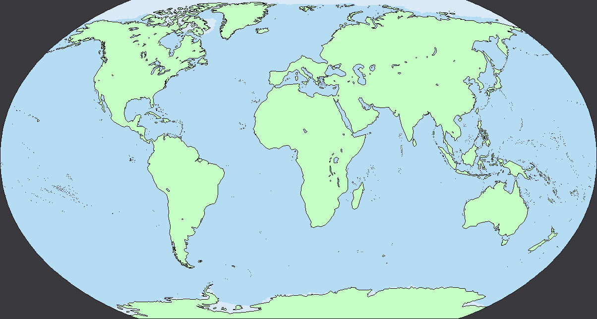
So I'm considering creating a fantasy setting heavily modelled on Earth with the exception that most of what we consider Northwest and Central Europe is replaced by sea. I decided to as a reference point modify a map of Earth made in Paint where I did just that, making sure to keep the Alps and the Danube (presuming my changes haven't changed the flow of the river in any way) since I'm aware how important those two features are to the climate of Southern Europe and the Balkans. Here's the map below for reference:

enter image description here

I was just wondering what unforseen effects this would have on global ocean currents and climate, especially around the Mediterranean.

$\endgroup$
6
  • $\begingroup$ You'll have warmer, wetter winters in Belarus, Ukraine and Moscow due to the Gulf Stream reaching further East and maybe North. Probably changed wind patterns around the Alps and on the Balkan. Also, depending on why there's an ocean, you might also have to omit the Alps, since they were created by plate collision. $\endgroup$
    – Erik
    Commented Jan 19, 2021 at 8:29
  • $\begingroup$ Iceland should be quite a bit balmier. Northeast Europe will be wetter. Possibly warmer, definitely getting "more" weather due to a larger and unimpeded feeder ocean. I suspect the loss of Scandinavia will be more relevant than the loss of UK, France, etc. It also depends on the ocean depth. Did the removal of NW Europe also remove its continental shelf, or is everything just lowered to just below sealevel? $\endgroup$
    – PcMan
    Commented Jan 19, 2021 at 8:46
  • $\begingroup$ Everything's just lowered below sealevel, and perhaps had been so since before the last glacial maximum ended, meaning a lot of the coastline above the Alps is pretty cliffed, with the border along northern Russia being littered with fjords created during the Ice Age $\endgroup$
    – Gnowos
    Commented Jan 19, 2021 at 8:53
  • $\begingroup$ Well, at least the climate of Romania, northwestern Russia, and the rump of Hungary will be dramatically different, switching from temperate continental with hot summers and harsh winters to temperate oceanic with mild summers and winters. (And nope, no fjords on the hypothetical coast of northwestern Russia; there is no place for them, as northwestern Russia is low lying. It would look much more like the coast of the Netherlands than like the coast of Norway.) $\endgroup$
    – AlexP
    Commented Jan 19, 2021 at 12:33
  • $\begingroup$ "Science-based" is a problem for this. To properly answer it you would need to run a general circulation model to see what happens to ocean currents, wind patterns, etc. And even then it would require some careful expressions of uncertainty. If ocean currents are strongly disrupted then it could make any given location much colder or warmer, much dryer or wetter. $\endgroup$
    – puppetsock
    Commented Jan 19, 2021 at 16:14

1 Answer 1

1
$\begingroup$

It would make what remained of Europe substantially warmer and wetter.

Your map has Russia and south Eastern Europe completely exposed to the ocean so rather than being continental in climate it would now be marine influenced. Warm currents of water from the Gulf Stream would flow into the sea where northwest Europe used to be, bringing precipitation much further into western Eurasia. The Pontic and Caspian steppe would instead be forests with the increase in rainfall, and overall this would make more of Central Asia temperate on this basis.

The Mediterranean basin would likely see more precipitation as well, at least in the northern half, and the rivers flowing from the Alps and Balkans would have substantially larger flow rates if the northern flanks of the mountains are closer to warm water currents.

$\endgroup$

You must log in to answer this question.

Not the answer you're looking for? Browse other questions tagged .