8
$\begingroup$

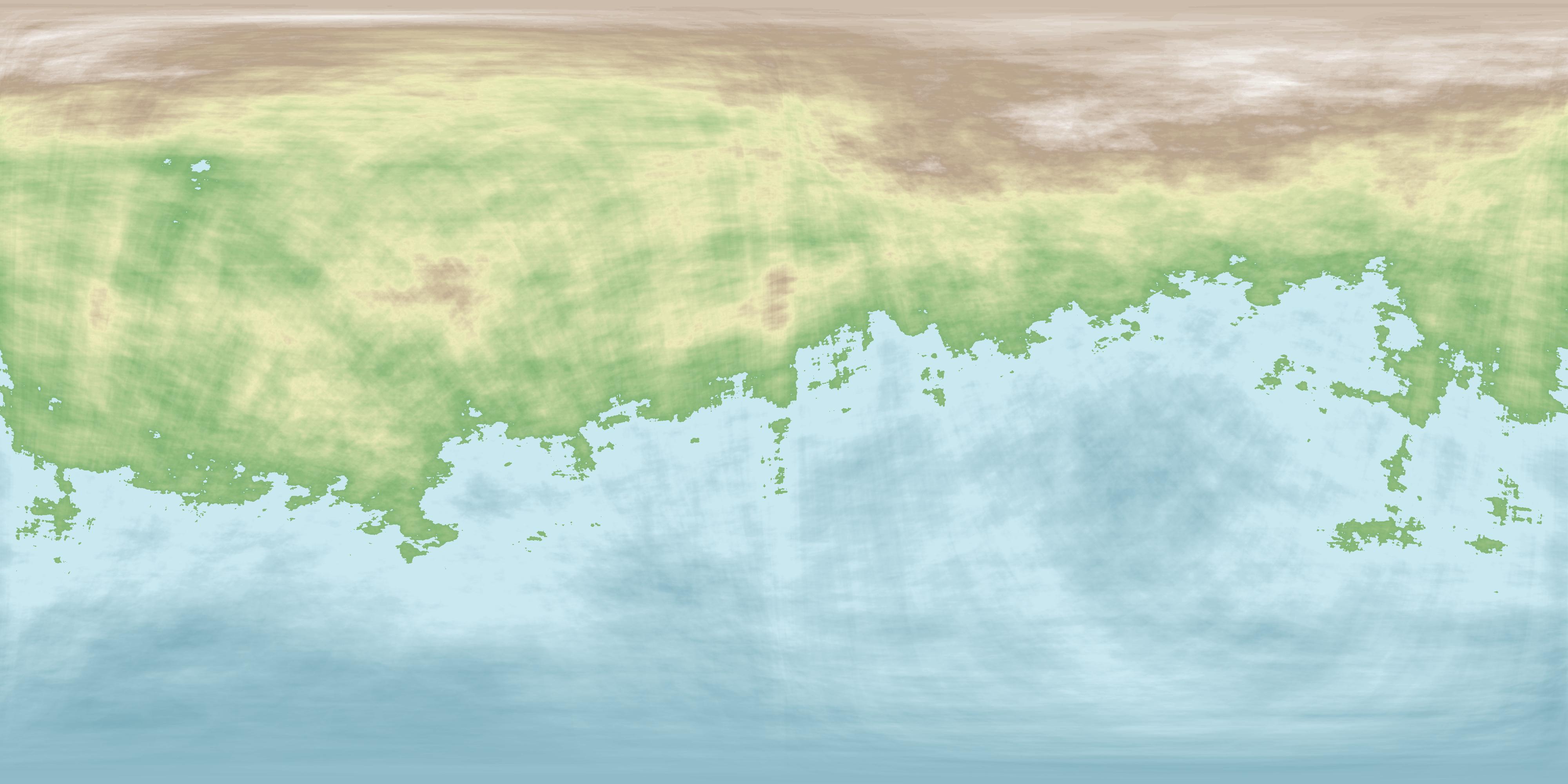
Here is a supercontinent map generated randomly from the Donjon website:

enter image description here

Now, hold on just a minute. Something looks wrong. The mountains in brown and white are too far inland to be caused by subduction, not linear enough to be formed by continent-continent collision and simply way too big to be justified by hot spot eruptions. How else could those mountains form?

$\endgroup$
6
  • $\begingroup$ Isn't the main "wrong" there the borders, and particularly the top border… that which "we" would normally see as North? Can you show a Here is a complete map, generated not randomly but specifically to show your terrain? Otherwise, isn't any Answer going to be random guesswork? $\endgroup$ Commented Nov 17, 2020 at 0:21
  • 3
    $\begingroup$ "...and then the Great God O'ooglebarsh, being much drunk from consuming the Wine of the Gods, did stumble, and then quoth he 'Oh, dear', and then did he drop the world. Yea, upon the very Floor of Creation didst he drop it, and it fell from a great height, a-way up there, and it landed on the Floor, a-way down there, and thereupon it went THUD! And lo! The mountains did rise, and the valleys did fall, and great was the tumult thereof - and serve 'em all bloody well right if you ask me" - the Gospel of O'ooglebarsh's Wife, chap. 3, verses 12-22. Makes as much sense as any other explanation... $\endgroup$ Commented Nov 17, 2020 at 17:52
  • $\begingroup$ There's actually a real-life example: the Ural mountains. See e.g. this question for a possible solution to your problem $\endgroup$
    – user29956
    Commented Nov 17, 2020 at 19:46
  • $\begingroup$ @Paul Even being 100% true, that doesn't help. What would help would be a wider map, showing more terrain on all sides and particularly above. Does that not work for you? $\endgroup$ Commented Nov 17, 2020 at 23:04
  • $\begingroup$ @RobbieGoodwin what's the point? The map shows the complete planets surface. Just render it into a sphere (see answers below) and you're good. Either way, what's not helpful about the Ural-example? $\endgroup$
    – user29956
    Commented Nov 18, 2020 at 13:53

4 Answers 4

30
$\begingroup$

Assuming that map is a complete planet, in cylindrical Mercator projection? It seems to be, with the characteristic lateral smudging of textures at the extreme top and bottom.

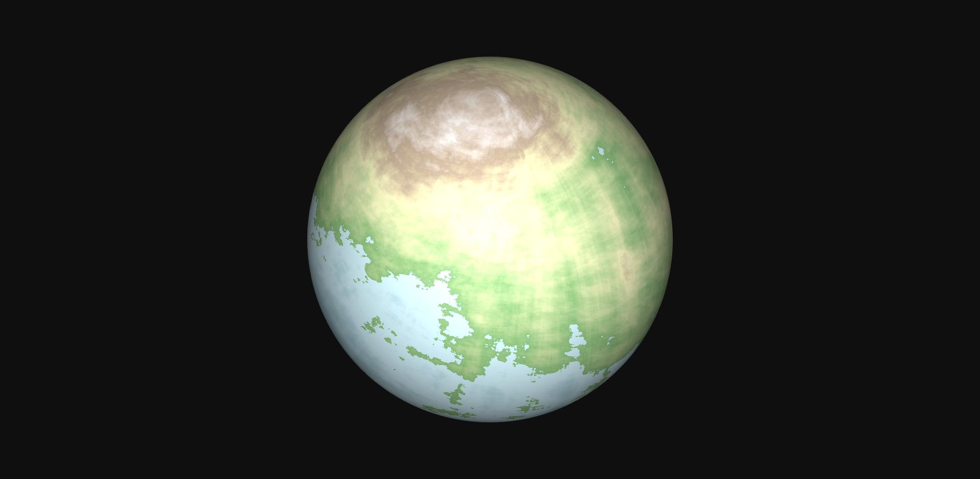
That smudged-looking mountain range at the top is actually an elevated north pole, with a roughly circular aspect.

It just requires a planet that took a hefty thump early in its life. Like Mars, where the whole North pole region is 6km lower than the South pole region.

Your map is the same, just inverted. North is high, and the lower south is occupied by an ocean.

This is your world on https://www.maptoglobe.com/ByWPZtkcw
Quite a nice looking globe, it is! enter image description here

$\endgroup$
5
  • $\begingroup$ Nice remembering Mars. Now OPs map is far more extreme (probably), but that could just be that it could be newer, with less time to even out $\endgroup$
    – Hobbamok
    Commented Nov 17, 2020 at 12:06
  • 3
    $\begingroup$ Talk about "there's a web site for everything!" Whoa! $\endgroup$
    – Fattie
    Commented Nov 17, 2020 at 13:54
  • $\begingroup$ That's not working. That mountain will move to the equator (i.e. the rotation axis will shift). Similar to Mars, where the big volcanoes are on the equator (but what about continental drift?) $\endgroup$ Commented Nov 17, 2020 at 22:20
  • $\begingroup$ @DavidTonhofer You mean similar to Mars, where a) there is no continental drift, and b) the mass imbalance due to the northern hemisphere depression is 75 times the mass of Olympus Mons? That Mars? $\endgroup$
    – user79911
    Commented Nov 18, 2020 at 5:08
  • $\begingroup$ @MarvinKitfox Yes, exactly that Mars. "Depressions" in polar regions are exactly what things tend to. Great tilt gave Mars a new face. No continental drift means things stay that way. $\endgroup$ Commented Nov 18, 2020 at 8:56
8
$\begingroup$

Continental - continental convergence.

The mountains are circumpolar and far inland. I assert the polar ice lies on top of an area of high elevation. This was formed by several continents all colliding together with a central polar continent. The analogous Earthly situation (with just 2 continents colliding) are the Himalayas and the Tibetan plateau.
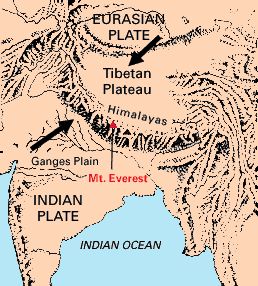
tibetan plateau

https://pubs.usgs.gov/gip/dynamic/understanding.html

Continental-continental convergence The Himalayan mountain range dramatically demonstrates one of the most visible and spectacular consequences of plate tectonics. When two continents meet head-on, neither is subducted because the continental rocks are relatively light and, like two colliding icebergs, resist downward motion. Instead, the crust tends to buckle and be pushed upward or sideways. The collision of India into Asia 50 million years ago caused the Indian and Eurasian Plates to crumple up along the collision zone. After the collision, the slow continuous convergence of these two plates over millions of years pushed up the Himalayas and the Tibetan Plateau to their present heights. Most of this growth occurred during the past 10 million years. The Himalayas, towering as high as 8,854 m above sea level, form the highest continental mountains in the world. Moreover, the neighboring Tibetan Plateau, at an average elevation of about 4,600 m, is higher than all the peaks in the Alps except for Mont Blanc and Monte Rosa, and is well above the summits of most mountains in the United States.

Just as tectonics pushed the Indian continent up against the Eurasian continent, forming inland mountains and a plateau, plate tectonics on this world pushed several Indian continent equivalents northwards and into the central polar continent. Thus the central area was pushed high, analogous to the Tibetan plateau and around it a circumpolar ring of Himalaya equivalents.

One might predict some north-south oriented highlands between where the Indian continent equivalents came up against each other and indeed, those can be found in at least 3 spots on the map. Those north-south linear mountains mark where the continents came together in their journey to the pole.

$\endgroup$
3
  • 1
    $\begingroup$ Except that continental - continental convergence gives the mountains a LINEAR shape, which is not what we're seeing in this map. $\endgroup$ Commented Nov 16, 2020 at 2:00
  • 1
    $\begingroup$ @JohnWDailey I guess the point of this answer was that if a single plate can create a very high plateau (of width not negligible compared to the length of the range!), several plates all pushing on the polar one from different directions could achieve something similar but way more. Make it slow down after doing the lifting and erosion (mostly glaciers) will take care of the Himalayan circumpolar crown! $\endgroup$ Commented Nov 16, 2020 at 16:44
  • $\begingroup$ Additionally, please note that the very polar region is a bit darker (=lower) than the area just below (80-85 deg N), which could be very well a leftover of such history! $\endgroup$ Commented Nov 16, 2020 at 16:45
8
$\begingroup$

The polar mountains are volcanic in origin.

This is a structure similar to Olympus Mons on Mars. A Gigantic shield volcano. Lower gravity and/or higher viscosity lava could be responsible for the height. Given the lack of really any features related to plate tectonics, it stands to reason that the planet has another tectonic regime, which allowed the shield volcanic to build up for eons. Maybe Io-like lid tectonics or delamination and upwellings like Venus might have. Both regimes could in theory support a carbon cycle.

Another solution, though it is close to the first would be that we are dealing with a large igneous province. Flood volcanism like the Siberian or Deccan traps can build up basaltic highlands to several kilometers. The Siberian Traps raise the land in the area of current Siberia by 2 to 3 kilometers.

$\endgroup$
4
$\begingroup$

Your question presupposes a single monolithic (pun intented) orogeny when there is absolutely no reason to think this. I propose these mountains would be the result of a long history of distinct mountain-forming events that happen to converge, concertinaing entire continents into the massif and raising them faster than they would have eroded otherwise.

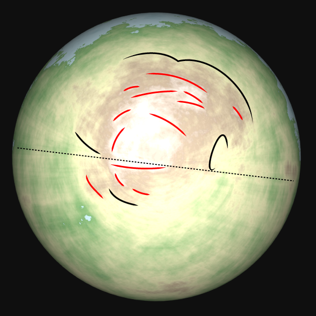
If you ignore the lines radiating from the pole – an artifact of Donjon's engine, which tends to create vertically aligned features – you can see there are linear ridge formations (red) and rather sharp drop offs between the raised polar region and remainder of the supercontinent (black):

Ridges

There is also a visible split between the top and bottom halves of the image, demarcated with a dotted line. This suggests the two halves are converging, with the top older (and a product of multiple convergences itself) than the bottom.

I won't speculate on the plate boundaries beyond that, but I suspect if you were to play with the sea level you'd reveal significant basins suggesting where the younger plate boundaries are.

(I highly recommend Torben's Planet Map Generator over Donjon.)

$\endgroup$
4
  • $\begingroup$ For your helpfulness and insight, I have to ask--maybe you could help me with some other worlds of mine that I haven't posted on SE? $\endgroup$ Commented Nov 17, 2020 at 11:18
  • $\begingroup$ @JohnWDailey I can certainly take a look, but I'm not a geologist or anything like that. $\endgroup$
    – rek
    Commented Nov 17, 2020 at 15:48
  • $\begingroup$ reddit.com/r/FantasyWorldbuilding/comments/jvg0s8/… The premise is that we have found an alternate universe in which there isn't one Earth, but nine, all of whom are microbes-only clubs. So our antagonist has them all terraformed. Conditions will vary between worlds, but for conversation's sake, let's all assume them to be the same--24-hour rotation, 23-degree tilt, oxygen filling in 30% of the atmosphere and 2200 parts per million of CO2. $\endgroup$ Commented Nov 17, 2020 at 23:37
  • $\begingroup$ @JohnWDailey I've messaged you there. $\endgroup$
    – rek
    Commented Nov 19, 2020 at 18:40

You must log in to answer this question.

Not the answer you're looking for? Browse other questions tagged .