12
$\begingroup$

Background: I'm continuing to work on the economy of my industrial age world. As background info, it's a fantasy world, with loose basis in western Europe, 1870-1914; though the presence of (essentially magical) airships, largely dirigibles and small planes, complicates that as a point of reference, and for this question later periods may be relevant. In this world trade is conducted primarily by air rather than sea. (I'm aware of the real world disadvantages of this; but for the sake of space you'll have to go with me for here.)

I'd like to map out the major airways for my world, so I can better understand the flow of trade. It's belatedly occurred to me that there's probably going to be a lot more to that than listing imports and exports and drawing a straight line; possible considerations include refueling, government / legal boundaries, weather, etc. Not having gotten into the weeds of the airship tech yet (there's a long to-do list) I'm not really sure how important any of that will be, and has been historically.

Which brings me to my question.

Question: What will be the major considerations for mapping out practical, economically competitive aerial trade routes? In short, as I approach this as a worldbuilding problem what are the main things that I should be thinking about?


Bounty Edit: In the next few days I'll be creating two 50 pt bounties to reward the two answers I found most helpful, Thucydides and JBH. They each addressed the question in useful detail, but as one focused on the big picture and the other on specific details I decided I couldn't fairly choose between them. I'm adding this note to alert users that, while more answers are always welcome and appreciated, the main answer is already selected and both bounties are set aside.

$\endgroup$
2
  • 1
    $\begingroup$ Have you done research on sea trade routes ? I think there is lot of similarities so it can be a good start $\endgroup$
    – Kepotx
    Commented Aug 8, 2017 at 23:58
  • $\begingroup$ You have to rationalize why airships have an advantage over sea, canal, river, and rail. Practically in our world airships are limited to about 70-90 mph -- not much faster than trains in the heyday of rail. $\endgroup$ Commented Aug 9, 2017 at 2:18

4 Answers 4

11
+100
$\begingroup$

Mapping airship routes starts with plotting the airports on a globe and then plotting the "great circle" routes between these points. This is the shortest distance between the two points. Finding the shortest distance will minimize travel time and the amount of fuel or energy you need to expend, making this the most economical route for transportation of people and goods regardless of the means of transport.

enter image description here

Great Circle Map

While this applies for any form of transportation, air transport is unique in that there are far fewer constraints. People on the ground have to contend with local geography, political divisions and people's claims to the land they wish to traverse. Ships on the open ocean eventually need to come ashore, and navigation in the littoral regions means dealing with land, sea currents and so on intruding on the Great Circle. Aircraft can serenely fly over obstacles, cross between land and sea and ignore most claims by small land owners as they transit the sky.

So the first order approximation is to plot the Great Circle routes between Zelda and Gondor. Once that is done, airships or aircraft (or witches riding brooms, depending on your scenario) then attempt to fly the route, making careful notes about navigation hazards like mountain ranges, prevailing winds or jet streams and if there are political boundaries which need to be avoided, lest you get blown out of the sky. With some experience, Captains will eventually plot the best routes, where to deviate from the Great Circle and where to rejoin it.

enter image description here

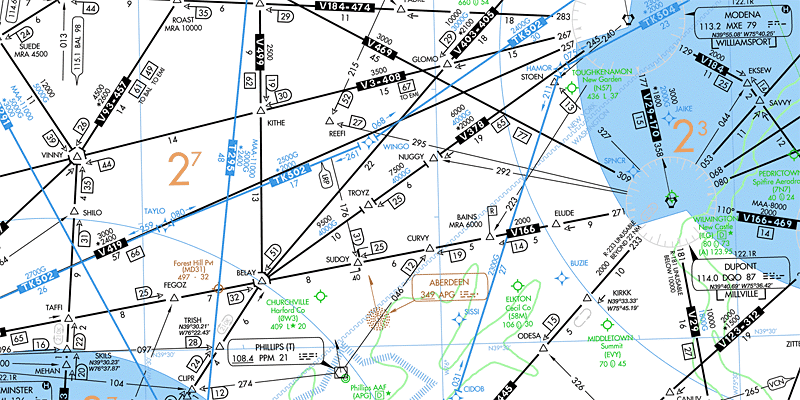
Air navigation map. This one is a low altitude IFR chart, which is probably appropriate for airships

Once that has been plotted, tested and codified, air navigation maps will have the routes plotted for Captains to follow and air transportation companies to use when offering service.

$\endgroup$
8
  • 1
    $\begingroup$ It's the shortest distance, but powered flight isn't the same as an airship. Do those routes make sense if you don't have a jet engine to push your way through them? $\endgroup$
    – JBH
    Commented Aug 9, 2017 at 0:45
  • 5
    $\begingroup$ Low altitude IFR is generally the regime for light aircraft and turboprop commuter planes in the modern age, airships would use the same maps/routes, they would just be slower and more prone to weather related diversions. A theoretical airship which had the performance of a jet aircraft in terms of altitude would still use the same routes, and have the same limitations WRT speed and weather. $\endgroup$
    – Thucydides
    Commented Aug 9, 2017 at 0:48
  • $\begingroup$ Political strife could factor in. As could air currents, weather. $\endgroup$
    – CaM
    Commented Aug 9, 2017 at 12:10
  • $\begingroup$ @JBH -- an airship is still "powered flight", just with a different energy regime than a jet. $\endgroup$
    – Shalvenay
    Commented Aug 16, 2017 at 0:11
  • $\begingroup$ @Shalvenay, Jets are capable of overpowering all but the worst kinds of wind, can reach altitudes above most weather, and have fuel-to-flight ratios that are very high. Therefore, they can draw straight flight lines. Airships cannot overcome most wind (they must instead use it), cannot reach altitudes to avoid weather, and have very low fuel-to-flight ratios. They almost never can use straight flight lines. All powered flight is nowhere near the same. $\endgroup$
    – JBH
    Commented Aug 16, 2017 at 0:20
7
+50
$\begingroup$

When it comes to an airship — and since you've said there's magic involved but didn't explain how, I'm going to ignore it — the problems are (a) lift and (b) being pushed around. Note that I can't imagine this to be a comprehensive list.

Wind For example, the Westerlies. There are "wind currents" just as their are "sea currents." Your trade routes will want to avoid head winds and take advantage of tail winds.

Mountains Altitude is normally an issue with airships. The higher you must go, the more costly and dangerous it is. You'll want to avoid high mountain peaks and tall ranges, preferring to slide along valley chains and take advantage of low passes. Also, generally speaking, note that wind gets worse with altitude.

The Sun As the earth rotates, the sun "pushes" air as it heats it (thereby expanding it). This causes more wind that can be predictably used or avoided. Think of canyon winds, which tend to be nasty in the morning and evening. Canyons "breathe" (air rushing in and out) and how they do depends on whether they're low point faces east or west. (BTW, this action is part of what creates the Westerlies).

Wind ShearWind shear is a very strong burst of wind, usually downward, and usually caused by meterological complexity, such as occurs around storm fronts or near mountain ranges. Denver International Airport is famous for the problems of wind shear. Without power, these need to be avoided and trade centers will (generally) develop in areas of low wind shear.

Thunderstorms & Tornadoes While thunderstorms can occur almost anywhere (and tornadoes less so, but still), there are areas of our planet where they are very common. Trade centers will want to avoid these areas. Note that both thunderstorms and tornadoes (and hurricanes) tend to create rotating wind, with will want to force an airship to turn, or may even cause it to spin like a top.

Lift Powered flight can deal with, for example, the poor lift of very hot areas. Air expanded from heat is less dense and therefore provides less lift. This makes it very hard to, for example, take off with a fixed-wing plane.

Airships react to hot and cold in the opposite way to fixed-wing flight, but they will nevertheless have similar problems depending on the nature of what gives them lift. Ignoring magic, if they're filled with gas, that gas will condense in cold — making polar transits difficult due to lower lift and the need to additional gas to compensate — and expand in hot — making equatorial or desert transits preferrable due to needing less gas to produce the same lift.

Water vs Land Routes For this issue I don't have enough background. My guess is that land routes will have more predictable wind and weather patterns and thus be more desirable. But, honestly, I could be wrong.


EDIT: One last thought. Sea routes are intrinsically limited in that you must have a port on the sea. Sea ports are desirable because the port is protected (a good harbor) and deep enough to handle the boats. They're also located, ideally, where train/vehicle access can easily get goods to the port, but that's secondary to the other considerations.

The considerations for air routes are different. Obviously, a port located within a circle of high mountain ranges is a problem, but why would you do that, anyway? You're economic trade centers would naturally form at area where the airships are swiftest and least costly to operate. Along Westerlies, a low altitudes and away from mountains. Etc. Sea routes almost must be developed second to the ports due to the absolute needs of ports. Airships are fairly the opposite where they might develop second to take advantage of the best routes, which won't be "port locked."

$\endgroup$
3
$\begingroup$

When trying to map out major airways, the main considerations for establishing central trade routes are landmarks, conditions, and traffic. First, to have a route that multiple parties cross on a frequent basis, you have to have points of interest and locations for orientation. Depending on the elevation most of your flyers are flying at, these would probably be like mountain ranges, rivers, and cities.

You could have the airways develop over the already existing trade routes from the past, or have a floating city/refueling dock where tons of aircraft meet and pass through.

Another thing to take into consideration is the conditions. Your airways are going to follow nearby jet streams and wind currents. They would be in places where the weather is predictable, or at least where it can be seen and reported quickly in case of a storm. Heck, since it's your world, you can make spots that have permanent storms and permanent sunshine.

Lastly, your airways are different than our modern world through trade. These aircraft are going to be passing one another, for safety, and for a common goal. There will be lots of aircraft going on the same route, because if that route works really good for someone else, it will work really good for you. You can have trading hubs, where all trade goes through at one point or other, and the routes and maps reflect that.

In general, mapping your airways and establishing trade routes in the skies just comes down to the location the aircraft are going to, their safety and speed while they get there, and why they're going there in the first place.

$\endgroup$
2
$\begingroup$

Although the great circles are the shortest routes, they are not necessarily the most fuel efficient routes. Those will follow the jet streams. I'm not sure if your magic is the equivalent of fuel; but the propellers on dirigibles are seldom a match for being blown along by a jetstream; they are for navigating into and out of them, for positioning when landing, etc. They could be used for long distance travel, but the most fuel efficient method is to position your ship in a jetstream; turn off the engine and let it carry you; then turn on the engine only for small navigational adjustments or exit. Much like boats on a network of rivers and canals.

Of course if "fuel" is infinite due to magic; the great circles are the physically shortest routes.

$\endgroup$

You must log in to answer this question.

Not the answer you're looking for? Browse other questions tagged .