5
$\begingroup$

Consider a large landmass such as Australia. Imagine if they hypothetically wanted to expand their borders, but they already used up all of their landmass, including the deserts.

Could humanity find a way to push back the ocean? For example, by building a series of gigantic barriers or dams, and then siphoning the water afterwards?

Or is it difficult or impossible to build standing structures in ocean water? Will it be destroyed before construction completes?

Is there any other method for human oceanic expansion? Such as building artificial, floating landmasses? Or by landscaping?

Good answers will explain whether expanding to the ocean is possible, and what methods of expansion do and do not work. Provide references to real-time instances of whether or not it has ever been attempted, if applicable.

Edit: I have done research on this. The difference between land reclamation and what I'm talking about is a matter of scale. I'm talking about expanding to such an extent that you could see a difference on the world map, or from space. I'm talking about creating land from the ocean the size of entire cities, entire countries.

I did not know that the Netherlands was almost entirely reclaimed.

I'm also talking about the potential of doing this in deep oceanic zones, not just shallow waters. The whole point of me posting this question was because I did some research but was unsatisfied by my findings, and because I want to know the scientific possibilities of this type of oceanic expansion.

$\endgroup$
9
  • $\begingroup$ You're gonna have to give a little more detail on what you actually want here, because it is trivially obvious that structures can and have been built in the sea, some of which have lasted quite a few years. What are you really asking, that the existence of oilrigs and the like doesn't already answer? Is it a question of scale? $\endgroup$ Commented Sep 17, 2019 at 19:03
  • 1
    $\begingroup$ Humans have problems living on dry land next to the sea. Incidental weather, coastal flooding, and tsunamis kill a lot of folks. $\endgroup$
    – user535733
    Commented Sep 17, 2019 at 19:05
  • $\begingroup$ @user535733 people have lived on coastlines for almost as long as there have been people. Clearly, none of those things hamper overall population growth, or discourage continuing settlement. $\endgroup$ Commented Sep 17, 2019 at 19:09
  • 2
    $\begingroup$ There is a country in Europe called the Netherlands. Half of its territory is on land reclaimed from the sea -- either below sea level, or less than 1 meter (3 feet) above it (and thus in the tidal zone). See polder. The Dutch have been expanding into the ocean since the Middle Ages. Their newest province, Flevoland, was reclaimed from the sea between 1942 and 1968; to do that they built a 32 km long dam (1927 to 1932) using 36 million cubic meters of sand and stones. $\endgroup$
    – AlexP
    Commented Sep 17, 2019 at 19:09
  • $\begingroup$ It's been done since at least the Roman times (not far off 2000 years, maybe longer). It's also quite extensive worldwide. The natural-floating version has been around for a long time too, artificial ones have been a work-in-progress for a few decades. Some basic research is appreciated. $\endgroup$ Commented Sep 17, 2019 at 19:25

3 Answers 3

5
$\begingroup$

as @L.Dutch already say theres many country do this.

the method

https://en.wikipedia.org/wiki/Land_reclamation

Land reclamation can be achieved with a number of different methods. The most simple method involves filling the area with large amounts of heavy rock and/or cement, then filling with clay and dirt until the desired height is reached. The process is called "infilling"1 and the material used to fill the space is generally called "infill".4 Draining of submerged wetlands is often used to reclaim land for agricultural use. Deep cement mixing is used typically in situations in which the material displaced by either dredging or draining may be contaminated and hence needs to be contained. Land dredging is also another method of land reclamation. It is the removal of sediments and debris from the bottom of a body of water. It is commonly used for maintaining reclaimed land masses as sedimentation, a natural process, fills channels and harbors naturally.

i just want to add singapore since they have different method.

https://www.scoopwhoop.com/singapore-trash-island/

How it works is that the garbage is turned into ash by Singapore's incineration plants and then shipped to the island.

The water between the two islands is divided into cells. These cells are drained before the ash fills them.Thereafter, it is covered with soil so that the birds and insects can pollinate and nourish the plants.

Before the ash-filled water is discharged into the sea, the wastewater treatment plant makes sure that it is properly treated.

The wastewater treatment plant is lined with an impermeable membrane to prevent the harmful substances from leaking into the surrounding waters.

Thanks to Singapore's mind-blowing efficiency, this landfill attracts a lot of rare species of birds and animals. In fact, it is one of the best places in Singapore for bird-watching.

TLDR watch this video

https://www.youtube.com/watch?v=Dei_duocsu4

and

https://www.youtube.com/watch?v=5VsDWhoh5WY

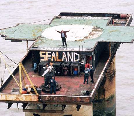
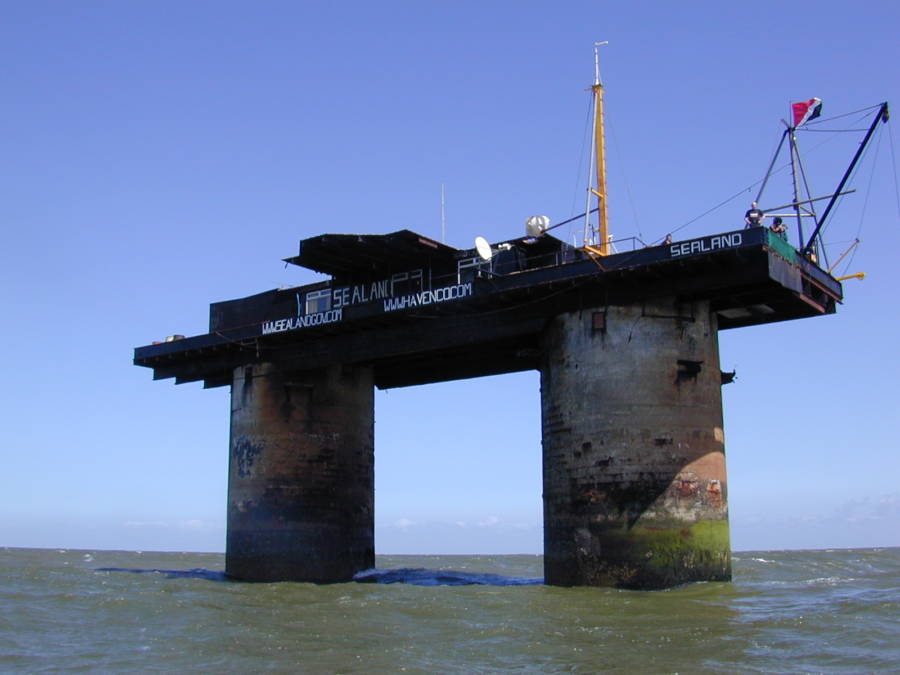
and as @Starfish Prime already mention theres a construction like oil rig use for residence such as sealand

enter image description here

enter image description here

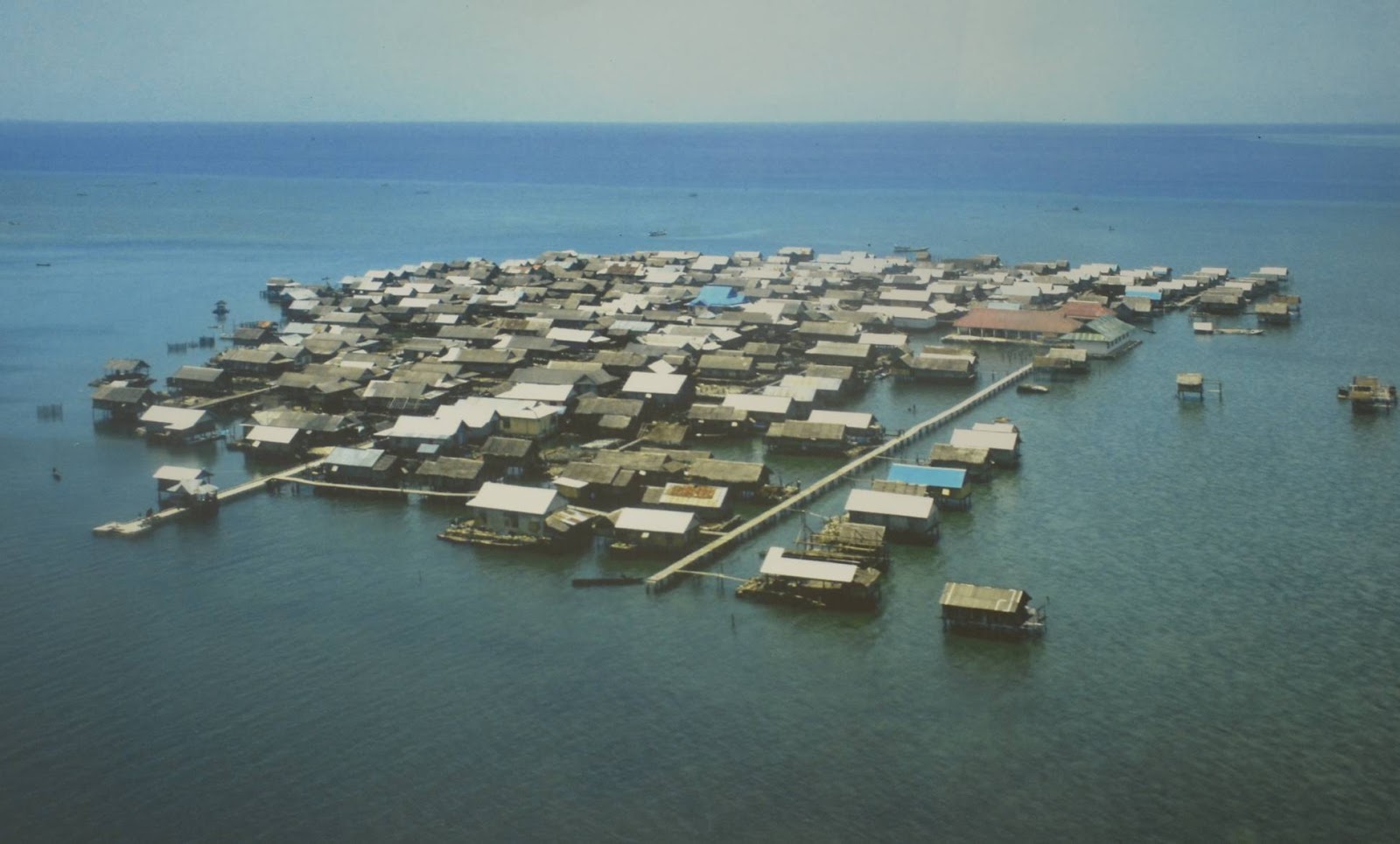
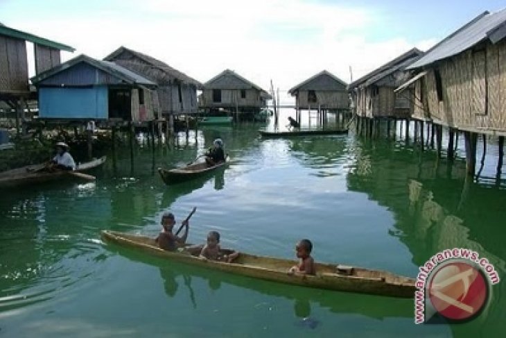
and more primitive one like village of bajau people

enter image description here

enter image description here

enter image description here

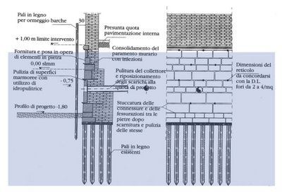
or maybe follow traditional venice method using wooden pile drive if you want stone or concrete architecture instead

enter image description here

enter image description here

$\endgroup$
9
$\begingroup$

We have some examples in our real world of pushing back the ocean, just to cite a few:

  • The Dutch Afsluitdijk

    The Afsluitdijk (literally translated: Shut-off-dike) was completed in 1932, thereby shutting off the Zuiderzee (lit: Southern Sea) from the North Sea. Until then, the Zuiderzee had been a large bay south of the North Sea which gave maritime access to five provinces of The Netherlands, and particularly during the Dutch Golden Age provided a protected entrance and exit for the harbour of Amsterdam and several other important Dutch sea harbours. Furthermore, the Zuiderzee provided relatively shallow and calm fishing grounds for the many towns bordering the bay. However, the opening of the Noordzeekanaal (North Sea Canal) in 1876 gave a much shorter direct entrance to the Amsterdam harbour, and overfishing had depleted the shallow bay. In the second half of the 19th century, the Dutch population was exploding, and there was an increasing need for land for agriculture and animal husbandry. The Dutch already had centuries of experience of building dikes around lakes, emptying them and converting them to fertile polderland. The next large project was to convert the Zuiderzee into polder. In 1886, a few notables established the Zuiderzee Society to investigate whether reclamation was feasible. One of the most prominent members of the society was Cornelis Lely, a prominent member and later chairman of the society. In 1891 he designed the first plan for the closure and reclamation of the Zuiderzee.

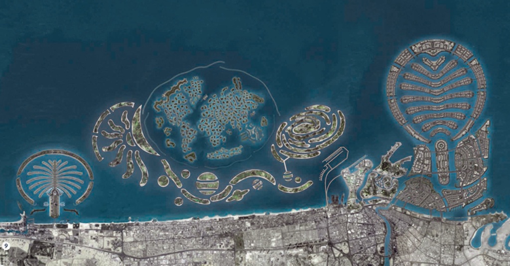
  • Palm Islands

    Palm Islands are three artificial islands, Palm Jumeirah, Deira Island and Palm Jebel Ali, on the coast of Dubai, United Arab Emirates. Creation of the islands started in 2001. Only Palm Jumeirah has been completed. This island takes the form of a palm tree, topped by a crescent. palm islands

  • Odaiba

    Odaiba (お台場) today is a large artificial island in Tokyo Bay, Japan, across the Rainbow Bridge from central Tokyo. Odaiba was initially built in this area for defensive purposes in the 1850s. The original Odaiba opened in 1860 as a port and shipyard in the city today known as Yokosuka, site of the joint Japanese-US fleet HQ. Reclaimed land offshore Shinagawa was dramatically expanded during the late 20th century as a seaport district, and has developed since the 1990s as a major commercial, residential and leisure area. Odaiba, along with Minato Mirai 21 in Yokohama, is among a few manmade seashores in Tokyo Bay where the waterfront is accessible, and not blocked by industry and harbor areas.

Of course the more shallow is the water, the easier it is to build such things. Note that they are not floating landmasses: to make such a mass float has little sense, as it would need connection to mainland for utilities. If you are going to anchor it, then better make it an island.

$\endgroup$
1
  • 1
    $\begingroup$ "it would need connection to mainland for utilities" tell that to the USS Nimitz, perhaps? $\endgroup$ Commented Sep 17, 2019 at 20:21
5
$\begingroup$

Let's do some Geo-Engeneering

Others have already proposed the sane ways for doing land reclamation, which leaves me with the insane ways of doing it. A question, dear reader, is this enough reclaimed land for your purposes?

enter image description here

This looks somewhat like current Earth, but all the continents seem to have gotten fat. The most noticeable changes are the now connected Australio-Papuaneuginea, Sundaland in the South-China-Sea, the Beringia-Landbridge between America and Asia, Doggerland in the basin currently occupied by the North-Sea and some truly humongous islands in the oceans (just look at Hawaii or the Caribbean).

Should one be familiar with the history recent history of Earth, it will be obvious that this isn't some kind of far future map or a crazy proposal, but a map of Earth during the Last Glacial Maximum. Between 31 and 16 thousand years ago Earth was about 6° colder and when the glaciers were at their maximum extent about 26500 years ago; sea levels were about 130 meters lower than today. This results in the coastlines shown above.

So how does this help us? We can see that a colder planet means more water bound as ice leading to lower sea levels and more land. Over the history of our planet sea levels have fluctuated between 300 or even 400 meters with the maxima during ice free climetes like in the Eocene (this article shows the shorelines current day Earth would have with an Eocene climate) and minima during cold ages like the Last Glacial Maximum. Thus we just need to cool down the planet in order to get more land.

Cooling the planet by a significant ammount is of cause no trivial task. One could opt to remove greenhouse gasses (at least carbon dioxide and methane, ozone and water vapor are harder to controll) or use space-based sunshades. While there are many proposals for sunshade construction, I like the self-stabilising design by Paul Birch and the swarm design most.

Paul Birch proposed a slatted system of mirrors near the L1 point between Venus and the Sun. The shade's panels would not be perpendicular to the Sun's rays, but instead at an angle of 30 degrees, such that the reflected light would strike the next panel, negating the photon pressure. Each successive row of panels would be +/- 1 degree off the 30-degree deflection angle, causing the reflected light to be skewed 4 degrees from striking Venus.

One proposed sunshade would be composed of 16 trillion small disks at the Sun-Earth L1 Lagrangian point, 1.5 million kilometers above Earth. Each disk is proposed to have a 0.6-meter diameter and a thickness of about 5 micrometers. The mass of each disk would be about a gram, adding up to a total of almost 20 million tonnes. Such a group of small sunshades that blocks 2% of the sunlight, deflecting it off into space, would be enough to halt global warming, giving us ample time to cut our emissions back on earth.

Alternatively one could also use titanic electrolysis plants to break up ocean water into hydrogen and oxygen so that the hydrogen may escape into space. Note that this is extremely energy intensive.

However this approach, with the possibile exception of the electrolysis scenario, will have other, unintended consequences. It will lead to droughts and desertification as the map below shows. Glaciers and tundra would also spread and take over most of Europe, Siberia and North-America while tropic and moderate climates will be forces into retreats near the equator.

enter image description here

$\endgroup$

You must log in to answer this question.

Not the answer you're looking for? Browse other questions tagged .