5
$\begingroup$

I already wrote here one question about my planet Artemis. It has size similar to Earth, it is orbiting its star in average distance like Earth, but with little bit larger excentricity (causing that differences in seasons in northern hemisphere are larger than differences in southern hemisphere).

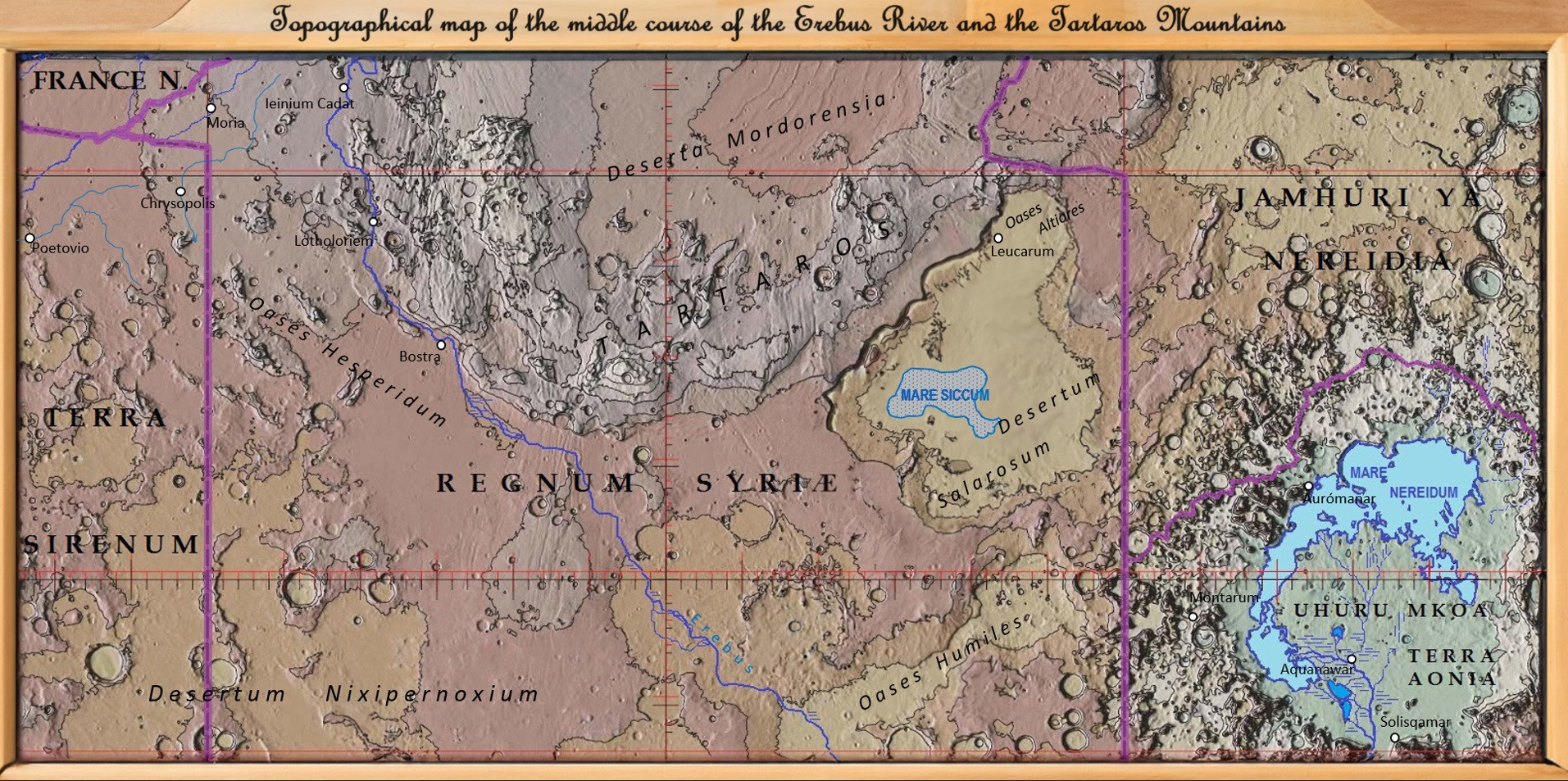
Oceans are placed only in northern hemisphere, deserts are almost completely covering southern hemisphere. I placed there two inland seas fed by rivers. One inland sea (Mare Nereidum) has size 350000 sqkm and is fed by river Erebus. Sea is placed at 45°-55° southern latitude, majority at 47°. It is surrounded by mountains rim with height around 5,5 km maximum (atmposhere composition is similar to Earth). Picutres of sea and planet are at hyperlinks inserted in text (in better quality) and I worse quality I uploaded picture of map with Mare Nereidum at the end of my question.

And here is my expectation, how this inland sea would influence surrounding, which I would like to ask you, if possible, whether I overestimated influence, or underestimated. I think, that evaporation will be not too high, therefore low placed areas around sea will have very low precipitation and will remain desert and semi-desert like almost all rest of southern hemisphere. However mountains can catch some evaporated moisture and I think, that they can catch sufficient amount of precipitation which will allow to grow at least some sparse forests. Is my assumption correct? How far can such sea of size 350000 sqkm influence surroundings?

My another assumption is, that in winter will be sea frozen, therefore winters in mountains will be with very few snow (which will fall in autumn) and majority of precipitation will fall in summer storms. Correct?

Thanks for any comments, answers in advance.

Map of Mare Nereidum

$\endgroup$
3
  • $\begingroup$ Is that map a modification of the lunar surface or something you created? It looks great! $\endgroup$
    – JBH
    Commented Apr 15 at 17:36
  • $\begingroup$ I modified map of Mars. In the deepest place I placed sea, then I placed rivers in the deepest places. I erased majority of craters and also I modified surface (created several depressions for instance Desertum Salarosum and Oases Humiles). $\endgroup$ Commented Apr 15 at 17:48
  • 1
    $\begingroup$ Excellent worldbuilding! $\endgroup$
    – JBH
    Commented Apr 16 at 1:25

2 Answers 2

6
$\begingroup$

With an area of 350,000 km² the sea is smaller than the Caspian Sea or the Red Sea, and about one and half times larger than the Persian Gulf.

  • The 438,000 km² Red Sea has some influence on precipitation along part of its coasts; the influence extends only on the south-eastern quarter of its coasts, and is limited to the western slopes of the Sarawat and Asir mountains. The rest of the coasts of the sea are as dry as the surrounding desert.

    The Red Sea has mountainous terrain on both sides, with the Red Sea Hills and the northern part of the Erithrean Highlands in Africa on the west, and the Hijaz, the Sarawat and the Asir mountains in the Arabian Peninsula on the east. The western slopes of the Sarawat mountains and especially the western slopes of the Asir mountains receive from 600 to 1000 mm of rain per year, which makes them incredibly wet for the Arabian Peninsula; this region was called Arabia Felix in the Antiquity. (It is modern-day Yemen, which goes to show that precipitation alone is not enough to make a country felix.)

  • The Persian Gulf does very little for the surrounding areas in terms of precipitation.

  • The Caspian Sea, like the Red Sea, influences the precipitation only on part of its coast. In this case, the influence of the sea is limited to the northern slopes of the Alborz Mountains which border the sea to the south. The sea's influence produces there a lush wet climate, which nurtures the Hyrcanian forests:

    The ecoregion's climate is humid subtropical at lower altitudes; at mid-altitudes it has oceanic features, while in the mountains it is humid continental. Summer is a humid but low-precipitation season. Alborz is the highest mountain range in the Middle East and it captures, by relief precipitation and dew point mists, much of the evaporation of the southern Caspian Sea. Annual rainfall ranges from 900 mm (35 in) in the east to 1,600 mm (63 in) in the west, making the forests much lusher than the desert, semi-desert, and steppe regions which it borders. ([Wikipedia, s.v. Hyrcanian forests)

    But the influence of the Caspian is restricted to its southern coast. In particular its eastern coast is just as desertic as the rest of the surrounding Karakum Desert which extends westwards right to the shores of the sea.

Conclusion

The influence on precipitation of the inland seas will be limited to sea-facing slopes of surrounding mountains, and then only those parts of the sea-facing slopes of the surrounding mountains which are favored by the prevailing winds.

$\endgroup$
0
4
$\begingroup$

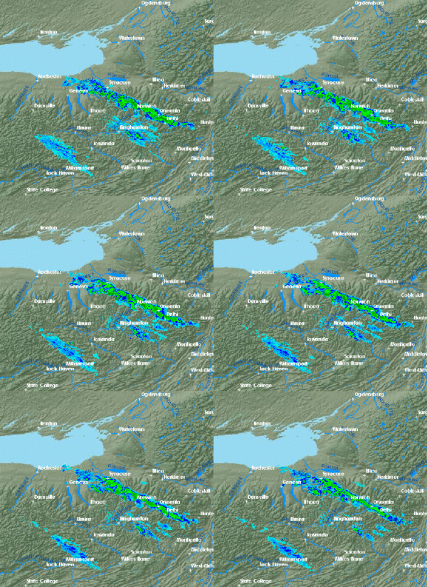
There is a term we use quite a bit around here, called Lake Effect that deals with this exact topic. While the term notoriously refers to long narrow bands of heavy snow (Lake Effect Snow), it also produces a lot of rain when temps are above freezing. These bands can sit over a single area for over a week in the right conditions. Lake Ontario produced 12 feet (3.5 meters) of snow in some areas during a 10 day snow band in Feb 2007.

Temperature and wind direction play a major role in lake effect. When lakes are warmer than the air, the lakes can generate large amounts of precipitation, even at long distances. The Great Lakes are 244,110 km² and produce thick cloud coverage and precipitation downwind, especially in the September through January months when the lakes are still warm. In the spring and summer, the lakes have little influence over the precipitation as the water is colder and the air is warmer and can hold more moisture. Even just a few miles away, downwind areas still can get drought conditions in the summer. Lakes as small as the Finger Lakes NY produce bands of precipitation in the right conditions (though the air is already saturated from the Great Lakes).

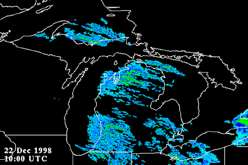
AlexP's examples are all saltwater bodies of water, which have a 20% lower evaporation rate than freshwater lakes, and it is in a warmer climate, so the effects are different than the Great Lakes area. It also doesn't require mountains downwind but the increase of elevation does increase precipitation. The bottom image shows a lake effect band sitting almost entirely over Lake Superior.

As far as your question regarding distance, I have seen lake effect bands reach Boston (+500km) in the right conditions. Typically a normal lake effect band reaches 100-200km in length, and the width usually depends on the lake size. You can also get multiple bands off of a lake.

Lake depth also plays a role as it increases the volume of water when it is deeper, allowing it to stay warmer for a longer period of time in the winter months.

enter image description here enter image description here

$\endgroup$
7
  • $\begingroup$ Here is a very nice map from the American Commission for Environmental Cooperation showing the actual extent of the influence of the North American Great Lakes on precipitation levels. Basically, nothing much, with some parts of the coasts being even drier than the surrounding areas. $\endgroup$
    – AlexP
    Commented Apr 15 at 15:15
  • $\begingroup$ Answer and also comment are very interesting. After answer I thought that exactly lake efect will take place in my Mare Nereidum. It is fed by huge river, so part of lake (western) has freshwater, eastern has higher salinity (like Balkhash in Kakazkhstan). But after seeing US precipitation map I am not sure, what could be real impact of this sea. Especially in arid surroundings (difference with US, with precipitation over 800 mm/yearly). I assume that impact of higher rainfall will be very localized in direction of winds and will be stronger in autumn due to lake effect. Correct? $\endgroup$ Commented Apr 15 at 16:17
  • $\begingroup$ if you look at a city at the tail end of the lakes, down wind, there is Oswego NY by the lake and you can see the different between precipitation in lake effect season and other months. Rome NY is further inland and there is even more precipitation. Though, as you get closer to the ocean, the data is affected by that with more summer rains. $\endgroup$
    – rtaft
    Commented Apr 15 at 20:53
  • $\begingroup$ Ironically, the map AlexP posted seems to indicate a clear difference in precipitation in Michigan on the half downwind from the lake, but the usclimatedata website doesn't show any sort of seasonal changes like it does in New York. $\endgroup$
    – rtaft
    Commented Apr 15 at 21:02
  • $\begingroup$ As far as its localized direction, in this area the cold front is typically followed by a high pressure that moves down below the lakes, pulling the cold air in a NE, E, SE, or sometimes South direction, so you get sort of an easterly wedge of precipitation as the high pressure moves through changing the wind direction. Since you are in the southern hemisphere, the high pressure spins the opposite, but the jet stream still goes W->E, so idk how much that would affect it. $\endgroup$
    – rtaft
    Commented Apr 15 at 21:21

You must log in to answer this question.

Not the answer you're looking for? Browse other questions tagged .