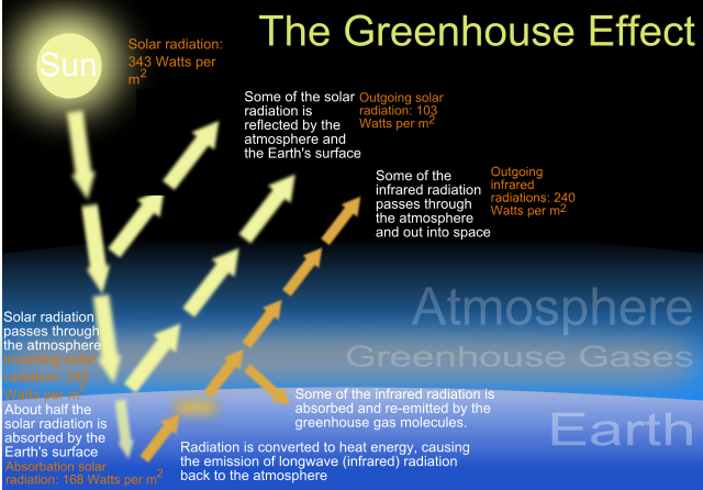
AS Wrzlprmft points out...you aren't going to have a rapid globe freeze or warm-up from an 'earth losses or gains energy' all to readily with a couple exceptions. I won't repeat Tim B's list...except to maybe add a massive space event such as a supernova wave coming our way, or even something off our sun (could have fun there as not only would it impact climate, it'd fry all of our monitoring electronics and make us close to blind)...but I'll give you the redistribution possibility.
The Earth is an incredibly efficient redistributor of energy...in a very short amount of time, energy circulates from the equatorial regions and makes it ways to the polar region to cool. I'll describe 2 main points, though there is a lot more to it:
North Atlantic. Warm water from the Caribbean makes it's way north on the surface of the ocean and makes it's way up towards Europe. The air currents warm on this and blow towards the UK and Europe, providing them with relatively warm trade winds that keep the northern regions relatively warm and rainy, even in winter months.
Pacific. The Pineapple express is a weather pattern (not just a pot reference) where warm air from hawaii and the tropical parts of the Pacific makes its way towards the pacific coast and provides a jet stream of relatively warm and humid air that keeps area's like Seattle and Vancouver very wet, especially in the winter months.
The opposite is true...though I suspect you have some knowledge of that (wunderground is a great site, realclimate is as well) where colder waters descend and make their way back towards tropical regions.
This system is a huge amount of energy in the works...so I'm not entirely sure what it would take to actually halt this system, but in the event it did, I can speculate a few things.
but first:
The storm situation in 'the day after tomorrow' has quite a few flaws in it and the cooling effect wouldn't be so rapid. They explain it as extreme cool air from the upper upper atmosphere being sucked down incredibly quickly by this massive storm...unfortunately that air is also the exact opposite of dense and would warm extremely quickly as it descended. Mountain ranges also have the noted ability to tear apart the air flow in larger systems like this and would prevent the storm systems from forming in their proximity.
second:
air currents move pretty rapidly, however it's not an over night change. It takes around 4 days for particles in forest fires in alaska to blow over canada and end up flowing through canada's tailpipe (the maritimes). Even at it's most extreme, I cannot see this change taking less than a couple weeks, even a couple months.
With that in mind:
Within a week of the system shutting down, water temperatures in northern ocean regions will drop significantly while the regions around the equator would quickly warm up. The UK would probably experience the effect first as the wind changes from Caribbean warmed trade winds to arctic winds coming off a cold ocean. It would happen relatively quickly (within the week time frame) and snow would start to take a permanent grip on the UK landmass. A similar event would start to occur on the west coast of North America as well.
The tropics are a different matter as they would begin to mass heat. There are 2 major factors in hurricane development...ocean surface temperatures and wind sheer. Higher ocean temperatures give hurricanes more energy that result in stronger winds and larger storm surges. I would suggest that hurricanes would be extremely more powerful than we have experienced in the past. That said, I would also expect less of them. Hurricanes are gigantic beasts and stretch from the earths surface to upwards of 60k feet into the air. This creates the scenario where the wind speed in the upper atmosphere can be significantly different than the wind speed at the surface...when this happens, the top of the hurricane that drives the force of the storm is ripped away from the bottom of the storm that has the rotation. So there would be less of an opportunity for hurricanes to form, but when they do watch out.
The end result (2 months?) would be a large icecap over the northern and southern poles and exceedingly warm tropical regions that would hit temperatures outside of what humans consider habitable. The region between the hot and cold would be a massive jetstream of wind that would likely produce sustained windspeeds far greater than what we've seen on Earth so far (I'd go as far as thinking the 'ring clouds' of Jupiter or Saturn could even form).
The only thing that I could consider for a 'abrupt change' is our failing to recognize that this is infact happening (or disagreeing that it is) and we don't realize until the massive hurricane or winter storm strikes. The change would likely be minor at first and not the easiest to detect until the abrupt onset of one of these storms (an arctic storm hitting the UK from the north, or a hurricane of abnormal proportions hitting the Caribbean/US or into the Philippines and china.
Adding in:
Don't neglect an extreme solar event from the list of potentials here. Space weather has a tremendous effect on earth and there is recent research that is linking our weather and storm systems directly to the weather of the sun and the magnetic lashes it sends us. An extreme solar event coming our way could also spawn a series of weather disasters and cripple our electronic ways of monitoring it.

