10
$\begingroup$

In my setting I have what is essentially air filled, zero gravity, space with floating islands scattered all over the place in a large, three dimensional cluster. What I'm wondering is how the skyship captains and others would be able to tell directions as there is no north-south axis and up and down are relative. In answer to David K I'm looking more for what directions to give to the helmsman then map coordinates

Edit: There is illumination, all islands glow to one degree or another; the islands are of varying shapes and sizes, some have relative tops and bottoms, others are more spherical; The islands have local gravity of varying strengths depending partially on island size; The islands drift based on strong storms, proximity of other large islands, and the movements of the "heart" of the cluster, basically a really big chunk of magic coral that produces gravity (oversimplification); This is in a fantasy universe, there is air throughout. It gets thinner and colder the farther away from any island you go. There are magics that can hold air at a specific pressure in a small area though so thinner air is only an issue if you get swept off your skyship.

$\endgroup$
16
  • 7
    $\begingroup$ You're going to have to elaborate a lot on the features of your setting in order to get any meaningful answers. Is there any illumination? Are the floating islands static or mobile? Do the islands have an orientation: an upper side and a lower side, or are they spherical? Do the islands have any significant local gravity? Without this, as far as we know, the answer is: "It's all pitch black and you only know there's an island when you smash into one". $\endgroup$
    – Monty Wild
    Commented Apr 26, 2016 at 6:44
  • 4
    $\begingroup$ Air filled, is that all magically at the same pressure or does pressure decrease with 'altitude'? $\endgroup$ Commented Apr 26, 2016 at 10:13
  • $\begingroup$ Does your world have radio? $\endgroup$
    – Shalvenay
    Commented Apr 26, 2016 at 11:42
  • 1
    $\begingroup$ "Air filled" and "zero gravity" do not mix. In even a free fall environment, there is nothing holding the air in place. Even something as big as Earth's Moon, which is the fifth largest known natural satellite to a planet in our solar system by radius, has too little gravity to retain any noticable atmosphere. Even Earth can't retain any atmosphere to speak of (short of causing orbital drag over relatively long periods of time) above 100 km or so. $\endgroup$
    – user
    Commented Apr 26, 2016 at 12:51
  • $\begingroup$ Are there stars visible? In other words, is this an actual "world", or is it like an alternate dimension? $\endgroup$
    – Liesmith
    Commented Apr 26, 2016 at 12:52

6 Answers 6

5
$\begingroup$

The environment you describe removes key problems that drove the development of navigational technology on the Earth, and introduces new problems (including some that are not obvious) in their place.

The effect of a horizon

One reason (perhaps the big reason) why it's so often so difficult to find your way over long distances at sea is that the Earth itself gets in the way. If you want to go somewhere more than a few dozen miles off-shore you need to have a good way to tell that you're going in the right direction without being able to see either your destination or any other landmark.

With your floating islands, this problem disappears. Everything is in line of sight (unless another island is directly in the path, in which case you would want to head to that island first).

Finding your way in the dark

On the Earth, it gets a lot darker at night than during the day, and things that could have been landmarks are no longer visible. On the other hand, you can see the stars at night. Navigators on Earth learned to navigate by whatever kinds of things they could see, which vary from time to time. In your cluster, there does not appear to be any reason for things to be more or less visible at different times.

The Earth's axis of rotation

The fact that the Earth rotates and that we can therefore see the apparent motion of several prominent objects (notably the Sun!) from east to west gives some obvious, natural directions for navigation.

OK, you've taken this away, which introduces an obvious problem, but perhaps relatively minor compared to the next one.

Degrees of freedom of movement

The fact that the Earth's gravity gives us obvious "up" and "down" directions is secondary to the fact that it keeps practically everything on the surface of the Earth. Until the development of aircraft (including balloons) there was no vehicle that could even consider traveling up or down. All long-distance travel was basically two-dimensional. In fact, even with modern airliners long-distance travel is nearly two-dimensional; a flight of 3000 nautical miles will rarely get even 8 nautical miles above sea level.

Even if you had an obvious naturally directed frame of reference in your cluster, early navigators would have to develop ways of directing their craft that humans have only had to deal with when sending spacecraft to the Moon or to more distant places.

Visibility

Although you have line-of-sight to practically anywhere you would want to go, the space between you and your destination is still filled with breathable air. The thickness of this layer of air around the Earth is only a few kilometers--11 km up, density is less than 1/4 of that at sea level, 20 km up, it's less than 7%, 32 km up it's less than 1%. So we can still see stars at night. Wikipedia says visibility through air would be limited to less than 300 km even in perfectly clear conditions--and with entire islands floating around in mid-air, it seems likely that other particles would be floating about, too. If the air between islands is really thin, though, that might allow the radius of visibility to be greater than it would have been in a uniformly thick atmosphere. And you have magic.

So visibility could be on the order of hundreds of kilometers, less if you allow any kind of clouding or floating particles. You could probably arrange to have visible stars in the distance (maybe only at the distance of the Sun from the Earth--they do have to be bright enough to be visible through all that air). But it sounds like that is not a planned part of your world; it may make more sense for the radius of the cluster to be much larger than the distance anyone can see from any island, even with a strong telescope.

The map keeps changing

If even a strong storm can move an island significantly, charts can't be very precise. If you could somehow plot the exact direction to an island that was much farther than you can see, it very likely wouldn't be where you expected it to be when you got there.

Technology matters--a lot

At a very low level of technology I think it is unlikely that navigation would be advanced much beyond having knowledge of which islands are close to which other islands. Since the islands drift, even local "sky charts" would be impractical; but people on each island would either be able to recognize the nearby islands or would know which was which by having tracked their motions across the sky.

Directions a sky captain would give would basically be, "See that island there? Go to it." If the island was too far away to see, you probably want to stop at another, nearer island to get further directions anyway.

Edit: I wrote most of the rest of this answer before I noticed the comment about "no radio ... tech level similar to the 1500s." That comment makes most of the rest of my originally-written answer obsolete, but I'm leaving it for reference, underneath the separator line below.

To have reference directions that one can give directions relative to, the way a captain in the 1500s could give directions relative to the compass card, would require more effort to keep track of the necessary reference directions than I think could be supported by the technology. You'd need either a very stable gyroscopic system or a lot of computing power to figure out what direction was what based on what you could see (and on how much what you saw was likely to have moved since it was last "charted"). So at that level of technology, as far as directions for navigation go, I think "go to that island you see there" is it.

Directions to manuever a vessel could still be given by angle of yaw and angle of pitch (having already assigned yaw, pitch, and roll axes to the vessel), but those would be directions relative to whichever way the vessel happened to be oriented when the directions were given.


Once you have radio technology then the visibility problem becomes a lot less severe. Radio waves will go further than light through the inter-island atmosphere, and you could set up radio beacons on each island that could be identified and located from very long distances away. The nature of the directions would be similar; the difference would be that rather than heading to where you can see the island, you would head in the direction that your radio locator indicated for the desired beacon. The fact that the island may drift is of little consequence, since the beacon will go wherever the island does.

Giving an arbitrary heading to the helm

Eventually, it might be desirable to be able to give some kind of "heading" direction to the helm of a skyship that doesn't depend on having a visible island or a beacon in the direction you want to go. The question is how long it would take for the usefulness of such a thing to outweigh the technical difficulty of achieving it. (Keep in mind that the problem of getting from point A to point B without getting lost at sea, which prompted so much of the development of navigation on Earth, would already have been solved.)

There are two obvious ways to indicate direction in three-dimensional space. One is three-component Cartesian vectors; the other is some sort azimuth-and-elevation system or localized spherical coordinates using two angle measurements. Steering by vectors does not seem attractive; do we ever tell someone to sail "twice as fast to the east as you do to the north"? So two angles it is. The question is, what are the reference directions from which to measure the angles?

Any such reference directions would probably be determined by a universal coordinate system imposed on the entire cluster; I don't think there's a general solution for specifying direction of travel without that. The universal coordinate system could itself be spherical, cylindrical, or Cartesian (or possibly something else, but I can't think of what).

There is an identifiable center of the cluster in the middle of its "heart". This gives you an "outward" direction (away from the center) at any other point in the cluster. This could be one of the reference directions for the azimuth-elevation directions that skyship captains would give to their helms; but if so, it pretty much requires that the universal coordinates also be spherical.

Another possible source of direction could be a magnetic field throughout the cluster. The lines of the field don't have to be completely parallel, just pointing in the same general direction within the space between islands. A magnetic needle could be mounted so that it always points "north" parallel to the local lines of the field (unlike a compass used for navigation on the Earth, which projects the lines of the field onto the Earth's surface). Assuming there were known ways to estimate and compensate for the deviation of the magnetic field wherever the skyship might be, this would give one axis of a universal system of coordinates that could either be cylindrical or Cartesian.

The problem with either spherical or cylindrical coordinates, however, is that directions get ambiguous when you're too near the main axis of the coordinate system. Which direction is it to New York from the north pole? Which direction to Beijing? They're both south, which is no help in figuring out how to fly to one of those destinations.

So I think the universal system would probably be Cartesian. One axis (aligned with the average magnetic field if there is one, otherwise aligned with some very important route or with an arbitrary direction) would be the "north" axis; another would be the "prime" axis. So that every skyship can always determine the orientation of those axes despite the drifting of the islands, people might set out a regular grid of floating radio beacons, with propulsion powerplants so that they can (almost) hold their stations relative to each other. Each beacon would report any deviations in its relative position by a signal carried by its radio transmissions. By triangulating a few of these stations, you could always determine where you were and (most importantly for the purpose of this question) which direction was parallel to each of the axes from wherever you happened to be.

It is also possible that a skyship would carry a gyroscopic system that (mostly) stayed aligned with the axes of the universal coordinate system, which might be more convenient for knowing which direction is which from moment to moment (especially if you don't have high speed computers to figure it out for you), but I think the regular grid of fixed beacons would still be useful to help correct any wobbling of the gyroscopes and to reset them if they tumbled completely.

Then to specify direction, think of an imaginary Earth's surface positioned with your skyship at the center of the globe, with the north pole exactly "north" from the skyship and the point at zero latitude and longitude exactly in the "prime" direction from the skyship. A command to head 30 degrees north, 50 degrees east would mean to point the skyship toward the point at latitude 30 N, longitude 50 E on that imaginary globe. (But I think it is likely that the "latitude" direction might be given as an angle away from the north direction rather than toward it; that is, you might say "head toward zero south" if you wanted to head exactly in the direction of the "north" axis.)

$\endgroup$
10
$\begingroup$

It's all convention anyways

The simple answer is to pick a point and two orthogonal directions arbitrarily.

For instance, the center of your capital island is the point of origin, north is towards the North Star and up is towards any perpendicular direction of your choosing. Once you have north and up, you can infer south, down, east and west.

Why so Cartesian?

Cartesian coordinates express a point relative to an origin based on three orthogonal axes. In your case, north, east and up are the three axes.

Now you take these axes, and do something different. North and east form the polar plane. Up is still up and should be perpendicular to your plane.

Now you express coordinates based on: distance to origin, angle on the polar plane (or polar angle, in all 360°), and angle to the up direction (azimuth angle, from -90° straight down to 90° straight up).

You now have a spherical coordinate system.

Why is this better? There are no arbitrary north, south, east, west, up and down direction. There is however an arbitrary plane, which includes an arbitrary 0° polar angle and coincides with the 0° azimuth angle. Remember, it's all convention anyways.

In a 3D space, expressing relative coordinates spherically makes generally more sense than Cartesiannally. You want to know an obstacle is X meters away in that direction. That it is X,Y,Z meters away from a point of origin that you yourself are U,V,W meters away from doesn't seem quite as useful.

It's all relative anyways

Absolute coordinates (whether Cartesian or spherical, or else) are of little practical use in most cases. In this case, I would advise Cartesian coordinates because it's easier to figure out Cartesian geometry.

Relative coordinates make more sense in practice. We experience the world relative to our point of view. You instinctively know where front/back/left/right/up/down is relative to you. Apply the same logic to the ship. In this case, I would advise spherical coordinates.

$\endgroup$
5
  • 4
    $\begingroup$ Are you advocating spherical coordinates in "expressing relative coordinates spherically makes generally more sense than Cartesiannally"? If my destination has Cartesian coordinates x,y,z and I am at u,v,w, the vector to my destination is x-u,y-v,z-w and the distance to travel is the square root of the sum of the squares of x-u, y-v, and z-w. Try computing the straight-line distance between two random points in space in spherical coordinates--the easiest way is to convert to Cartesian coordinates as the first step. $\endgroup$
    – David K
    Commented Apr 26, 2016 at 13:37
  • $\begingroup$ @DavidK Your destination would have spherical coordinates relative to you, and that's all you would need. That's what I meant. $\endgroup$ Commented Apr 26, 2016 at 13:50
  • $\begingroup$ I think we're trying to solve different problems. I want to mark the coordinates of the islands on a chart. Your way is fine for giving instructions to steer the vessel. Now that I look at it again, the question is ambiguous, so I'm requesting clarification. $\endgroup$
    – David K
    Commented Apr 26, 2016 at 13:58
  • $\begingroup$ @DavidK If you are looking to build a map, then I agree, Cartesian coordinates make more sense. If you are using said map, likewise. If you are looking to get to your destination, spherical coordinates make more sense. $\endgroup$ Commented Apr 26, 2016 at 14:51
  • $\begingroup$ translations in spherical is much more complex, leading to a very centralized coordinates system, which can influence the whole world (politically, geographically,...) $\endgroup$
    – njzk2
    Commented Apr 26, 2016 at 15:16
7
$\begingroup$

Hubwards, Rimwards, Turnwise and Widdershins.

If there are no fixed points then you have a problem. If there's an orbital mechanic of some sort then you have one of your directions, with the turn or against it.

You have to remember that everything is ultimately arbitrary. Since you're in three dimensions then you'll have to pick three cardinal directions, give them fix points to plot relative to and you're done. Don't forget about the North Star (Polaris) and the Southern Cross when you're thinking about this.


Glowing Islands

You have constellations. They consist of other islands but some will be brighter than others, they'll form patterns, hence you can navigate.

To a certain extent this is "all roads lead to Rome" grade navigation, but it gives you a basis to allow ships to get around. Remember that we've been sailing the seven seas for thousands of years but a method of accurate navigation on open seas was only developed 200 years ago.

Skyship captains will be plotting courses between known points, spending as little time free navigating in open skies as possible. They'll be island hopping. The journey from A to Z passes through every point in between.

$\endgroup$
0
$\begingroup$

So, since the question does not address some vital issues, I'll make stated assumptions of my own to start:

  1. IF Air pressure is not constant throughout then you have an easy UP-DOWN dimension. Down is the opposite of the direction of Gasping Death. We'll instead assume that the air pressure is constant somehow (transparent handwavium alloys)

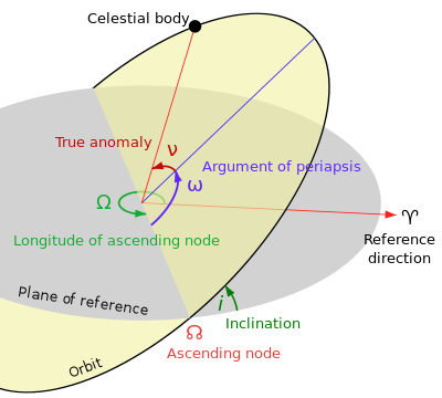
  2. IF there are outer stars visible, then you can use them to define a simple 3-D coordinate system. Pick a North Star. Pick another bright star at a 90 degree angle to it. Call that your reference direction ♈ as your vernal point that defines your plane of reference. Find the island in the center of your air-ocean, or the empty air-filled void therein. You now have all you need to calculate the longitude of the ascending node (☊), Inclination ($i$), and the Argument of periapsis $\omega$, from an idealized position in the center of the air-filled sphere.

enter image description here
Kinda like this, but likely with empty air rather than earth in the center, unless there is a central island

  1. IF the Islands move in a regular orbital pattern (ellipses), you need just a few parameters to know where they are at any point in time (orbital distance from the imaginary center of the sphere, measured in mega-Yoshis plus 3 for their stated positions at the start of the Epoch, $T_0$ and from the center plus 3 corresponding velocities for their movement during the next $\Delta t$ interval. Depending on the shapes of the orbits, you may need also need Eccentricity ($e$), and the Semimajor axis $a$, but we'll assume clean circular orbits for simplicity.

This means you can just have a set of navigational charts, assuming your captains have moderately accurate clocks. If it is Huesday, Vapril 4th around the first orbit of Sony, Mario Island will be at ($MY$45$i$35°☊60°$\omega$39°) moving with a speed of ($MY$0$i$5"☊6"$\omega$0.3") over the next Sony orbit.

$\endgroup$
5
  • $\begingroup$ Your figure has four angles (three if you combine periapsis and anomaly) and yet only shows the direction to the body, not the distance. Two angles is enough for that. The usefulness of that figure is in case 3, to describe the paths of objects in orbits (so that you can track the position using just one variable angle and its rate of change, not three parameters for each). For a freely moving vehicle in space I think you'd want something with fewer parameters overall. $\endgroup$
    – David K
    Commented Apr 26, 2016 at 13:51
  • $\begingroup$ @DavidK, hence the orbital distance from the center in Mega-Yoshis. But I agree, a simpler method (6 params) might be better. $\endgroup$ Commented Apr 26, 2016 at 13:56
  • $\begingroup$ We actually do calculation the positions of the "floating islands" in our own solar system using a combination of your part 2 and some of part 3, and it has proved to be an excellent system for that purpose, so I have no complaints about using it for the same purpose if these floating islands also follow regular elliptical orbits. $\endgroup$
    – David K
    Commented Apr 26, 2016 at 14:01
  • $\begingroup$ @DavidK, I'm a dilettante at best when it comes to this, I would love to see your answer... $\endgroup$ Commented Apr 26, 2016 at 14:06
  • $\begingroup$ @DavidK Unfortunately OP specified "zero gravity" likely without realizing exactly what that's asking for... (it stands to reason that the OP meant a free-fall environment rather than a zero-gravity environment, but that's not what was written!) Both zero gravity and free-fall environment additionally have the same problem that there's unlikely to be any atmosphere to speak of... $\endgroup$
    – user
    Commented Apr 26, 2016 at 18:16
0
$\begingroup$

If the islands glow, then you can see other islands in the sky. You can navigate by having a map of the relative positions of these islands.

Do the islands travel in orbits around something, or are they just floating motionless? Well, if they have gravitational fields, then if the laws of physics as we know them apply, they attract each other, so they have to move in orbits or they will slowly drift together and collide. How long has this place existed? How big are they and how far apart are they? Are there other forces involved? Etc.

But moving or not, if the movements are predictable, you could make maps. Navigation would be simpler than on Earth, as you can always see your destination in the sky. Well, assuming it is not directly behind another island from your perspective, and that it's light is not drowned out by other light. If it's far enough away that it's light is too dim to see or to distinguish, then you'd use your maps. You'd say, yes, island A is far away, but you can see from this map that if we head toward B, and then from there head toward C, that then we'll be able to see A and complete the trip.

I think the simplest method of describing positions would be to use Cartesian co-ordinates, i.e. x, y, and z with perpendicular axes. If there is no well-defined center of this place, pick an arbitrary point to be 0,0,0. Like the largest known island. Or some island that is a recognized social or cultural or scientific center. If there's no natural direction for the axes, just pick arbitrary directions and who cares? Just like, on Earth the equator and the poles are naturally-defined places, but there is no natural zero longitude. So we picked a place, Greenwich England, and we go with it. It could have been anywhere.

As to terminology: We use north, south, east, and west because they come naturally from the fact that we live on the surface of a rotating sphere. In a free 3D space, if there's no center of rotation or anything else that defines a natural axis or basis of direction, you'd just have to pick something arbitrary. I imagine people would just make up names. They'd plot the 3 axes in arbitrary directions, and then make up names for those directions. So they call them fwac and plugh and boobaloo or whatever. If they were living and working with these names every day, they would seem completely normal and natural to them, and words like "north" and "west" would be strange, unfamiliar terms that would have to be explained.

$\endgroup$
0
$\begingroup$

The answer is unfortunately as boring as they come: they would tell directions using the information they can acquire.

This issue you raise is actually a real issue for robots today. Consider your Wii-mote on your Nintendo Wii as the simplest example. Point it in the air, straight up. Link responds by holding his sword up. How did it know it was pointed straight up? Now point it at the screen to select an item. How did it know which item was being pointed at? Did you know the answers to these questions are different?

In the case of the Wii-mote, it has 3 sensors:

  • A 3 axis accelerometer, measuring acceleration
  • A 3 axis gyroscope, measuring relative angular position (if you have the Wiimote plus)
  • A small IR camera on the front

When you hold the Wiimote up high, it notices a roughly 9.8m/s^2 acceleration from the accelerometer. Because the Wii is played on the surface of the Earth, not on the moon or in space, it can deduce that that acceleration is probably the acceleration of gravity. From that, it can determine the orientation of the wiimote pointed up. In fact, if you swing it around, Link can swing his sword in the game because we can look at both the accelerometers and the gyros and integrate them to get a remarkably good estimate as to where the Wiimote is.

However, this is no where near accurate enough for pointing at a screen. The sensors just aren't accurate enough to pick up the fraction of a degree difference in where things are on screen. Worse, it doesn't even know much about where the screen is, so it doesn't know the conversion from degrees to pixels onscreen. The Wiimote has an IR camera to help with this. If you point it near the screen, it sees the two bright IR LEDs on the Sensorbar, and it can use that information to deduce where it is being point at, as long as it's somewhere near the screen. (In fact people with broken sensorbars have been known to replace the IR LEDs with candles at the right spacing, with the same effect!)

I point these things out because your space captains would not be foolish. They too would use every bit of information available to them, including magical devices which are outside of the realms of physics. That being said, here's a few examples of real life ways we do this:

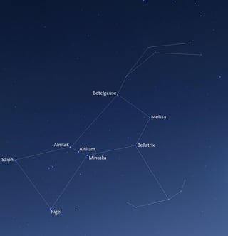
Stars
Star shot
There is a long history of using the stars to provide a universal alignment. You can't tell your position from the stars, but you can tell your orientation, and that was the specific question you posed here. If you can identify patterns in the stars, you can use those stars to figure out which direction you're pointed. Many amateur astronomer telescopes actually have an option to shoot 2 or 3 stars, and have the telescope's computer figure out the orientation of the telescope. From that point on, you can look up any named star, and it figures out where to move the gimbal.

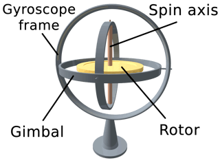
Gyroscopes
Gyroscope
Gyroscopes have been used for a very long time as a way to get a very accurate measure of your orientation relative to when you started. They do this by spinning a large mass. Due to the law of the conservation of angular momentum, this mass will not want to change the direction you spin it when you tip it. (There are actually many classroom setting experiments you can do to show this!). If you put the gyro on 3 gimbals, so that it can rotate in all directions, the spinning disk in the middle of the gyro will remain in the same orientation (roughly), and the gimbals will all permit the body of the gryo, and whatever is holding it, to move around it. You can then look at the angles of the 3 gimbals and determine your orientation.

A fascinating issue with these is called gimbal lock, when two of the axes line up. When this happens, you lose track of one axis because two of your measurements are in the same line. This almost happened on Apollo 11. While gimbal lock is avoidable with a 4 axis gimbal, we chose to fly a 3 axis gimbal with a neat logic circuit that, when we approached gimbal lock, it would flip one of the gimbals around to avoid the issue. During Apollo 11, they got close enough to this point that the computer started doing calculations, and ran across a bug in the code. Rather than take the whole computer down, the computer simply disabled that functionality and moved on. This meant Apollo 11 was flying very close to gimbal lock, with no protection.

This story and the star shot are related. NASA likes contingencies. They planned for this situation. If this occurred, the astronauts were to take star shots out of one of the windows of their capsule, just like mariners 400 years before them. Those angles would not be good enough to land on the moon (they would have to abort), but they would have been good enough to get them home safely!

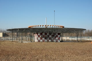
VOR
VOR
If you ever see one of these strange contraptions at an airport, it is a VHF Omnidirectional Range antenna (VOR). It outputs two signals. The first is a sine wave encoded onto one AM channel. The second is a phase delayed version of that same sinewave encoded on a different channel. Each of those antennas you see in the picture outputs a different phase. Thus, if you listen to both frequencies, and extract those two sinewaves, you can figure out which direction you are, with respect to the airport, just by comparing phases.

This one is different from the others in that it is an active system. It requires an antenna on the ground. However, this has some interesting advantages that you can't get from the passive version. For example, you can start to tell range, not just angles. This is enough to get positions. If you can find two VORs stations that you can hear at the same time, you can triangulate. If you can't find that, you can fly perpendicular to the VOR signal, and use your groundspeed compared to the rate the VOR signal is changing to tell you how far you are from the station!

GPS
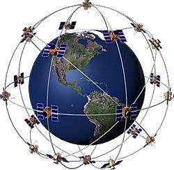
GPS constellation
This might be a bit extreme for your story, but it'd be silly not to mention GPS, because virtually every computerized moving object today has a GPS receiver in it. GPS operates in a surprisingly simple and surprisingly sophisticated way to tell you your position and velocity (but not orientation). All of the GPS satellites overhead output a signal containing information about their orbits. These signals are carefully phased locked so that you can measure the relative time you receive each signal. Light, and radio waves, propagates at roughly 1 foot every nanosecond, so if you can measure the relative time it took to receive the signals to a nanosecond, you know the distance (within a foot) of where you're at! It takes a fix on 4 satellites to give you a good location for where you're at via triangulation, and there's 24 of them circling the globe.

GPS is an interesting oddity because of how precise you have to be able to measure time. In fact, it is hailed as one of the empirical validations of Einstein's relativity. The satellites are moving so fast and the timing constraints are so tight that you actually see position errors if you do not account for the time dilation effects of relativity!

The Enemy's Gate is Down
To close, I'd like to address one final issue that arises in these systems. You specifically mention "how do they determine up vs down if directions are relative." The answer is "they don't." Why would you try to determine something that you know you cannot determine. Instead, you define your axes in whatever direction is most convenient.

The most famous example of this that I can think of in fiction is Enders Game, with the famous Battle Room. The Battle Room, for those who haven't read it, is a zero gee room where they practice space combat tactics. Players enter from opposite sides of the field and duke it out. Ender, the main character, noticed that many people were keeping their mental orientation that they had when they stepped into the room, assigning one wall to be the "ceiling" and one to be the "floor." This caused all sorts of strategic nightmares because it fixed an axis arbitrarially -- 4 of the possible "floor" choices were technically all the same. Instead, Ender chose a 5th orientation. He told everyone to think "The Enemy's gate is down." This way of thinking oriented his team to the only axis which actually mattered in that room, as opposed to picking an arbitrary useless axis. This was a major factor in his team's success.

$\endgroup$
1
  • $\begingroup$ About star sightings on Apollo, don't forget the regular fine platform alignment! $\endgroup$
    – user
    Commented Apr 26, 2016 at 18:13

You must log in to answer this question.

Not the answer you're looking for? Browse other questions tagged .