Became Hot Network Question
added 114 characters in body
Source Link

In the book series I'm currently working on, there's an archipelago around the size of Australia that is headed by a single tribal chief in the capital city of Jubenar. The archipelago is very sparsely populated, being home to only about 5 and a half million people. This is extremely apparent when looking at the towns and capital, which are basically oversized villages. The majority of the population is rural and scattered among hundreds of small farming and fishing villages in the interior and along the coasts. This chiefdom is sort of halfway between the stone and iron ages, with stone tools being the norm but iron arriving through international trade is quickly picking up steam.

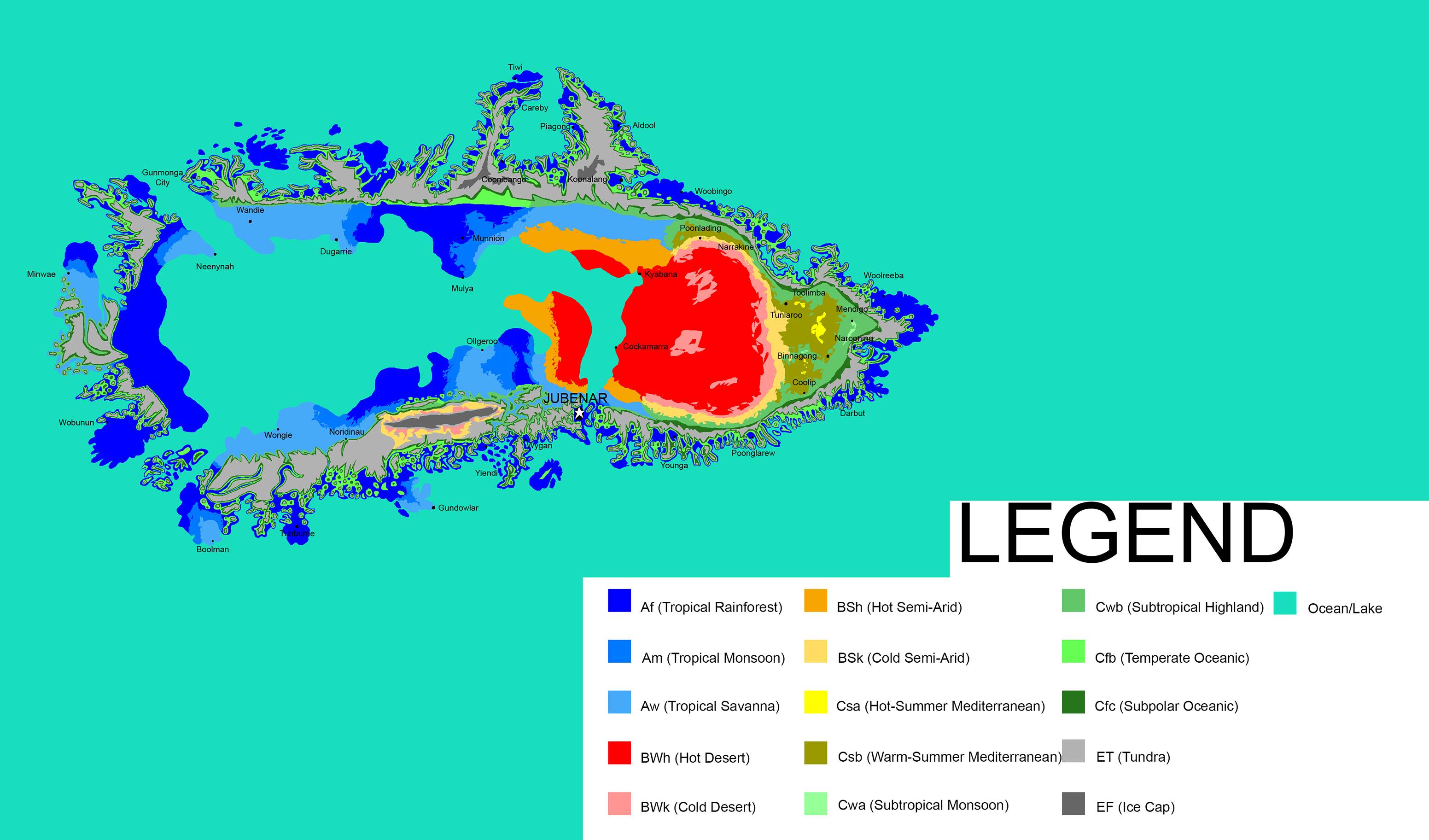
In addition, the geography of this archipelago is extremely varied and rugged, as seen below on the Koppen climate map of the region: Koppen Climate map of the archipelago. Settlements with populations above 5,000 are shown as labelled dots. The capital of Jubenar is only home to around 60,000 people.
How could a tribal chiefdom based in what is essentially an overgrown fishing village govern what is basically a continent the size of Australia with extremely rugged terrain such as this?

Note: the culture and technology of this archipelago is largely based on those of various Australian Aboriginal cultures, with some Maori and Viking influences they picked up through trade with outside powers. Yes, I am aware this map resembles Greenland a bit too closely and I am working on fixing that, but the overall point still stands as the fundamentals of the climate and terrain types will not change much. Also it's probably worth noting that this archipelago's center pretty much sits directly on its planet's equator.

In the book series I'm currently working on, there's an archipelago around the size of Australia that is headed by a single tribal chief in the capital city of Jubenar. The archipelago is very sparsely populated, being home to only about 5 and a half million people. This is extremely apparent when looking at the towns and capital, which are basically oversized villages. The majority of the population is rural and scattered among hundreds of small farming and fishing villages in the interior and along the coasts. This chiefdom is sort of halfway between the stone and iron ages, with stone tools being the norm but iron arriving through international trade is quickly picking up steam.

In addition, the geography of this archipelago is extremely varied and rugged, as seen below on the Koppen climate map of the region: Koppen Climate map of the archipelago. Settlements with populations above 5,000 are shown as labelled dots. The capital of Jubenar is only home to around 60,000 people.

How could a tribal chiefdom based in what is essentially an overgrown fishing village govern what is basically a continent the size of Australia with extremely rugged terrain such as this?

Note: the culture and technology of this archipelago is largely based on those of various Australian Aboriginal cultures, with some Maori and Viking influences they picked up through trade with outside powers. Yes, I am aware this map resembles Greenland a bit too closely and I am working on fixing that, but the overall point still stands as the fundamentals of the climate and terrain types will not change much.

In the book series I'm currently working on, there's an archipelago around the size of Australia that is headed by a single tribal chief in the capital city of Jubenar. The archipelago is very sparsely populated, being home to only about 5 and a half million people. This is extremely apparent when looking at the towns and capital, which are basically oversized villages. The majority of the population is rural and scattered among hundreds of small farming and fishing villages in the interior and along the coasts. This chiefdom is sort of halfway between the stone and iron ages, with stone tools being the norm but iron arriving through international trade is quickly picking up steam.

In addition, the geography of this archipelago is extremely varied and rugged, as seen below on the Koppen climate map of the region: Koppen Climate map of the archipelago. Settlements with populations above 5,000 are shown as labelled dots. The capital of Jubenar is only home to around 60,000 people.

How could a tribal chiefdom based in what is essentially an overgrown fishing village govern what is basically a continent the size of Australia with extremely rugged terrain such as this?

Note: the culture and technology of this archipelago is largely based on those of various Australian Aboriginal cultures, with some Maori and Viking influences they picked up through trade with outside powers. Yes, I am aware this map resembles Greenland a bit too closely and I am working on fixing that, but the overall point still stands as the fundamentals of the climate and terrain types will not change much. Also it's probably worth noting that this archipelago's center pretty much sits directly on its planet's equator.

Source Link

How Would A Tribal Chiefdom Govern a Colossal Land Area?

In the book series I'm currently working on, there's an archipelago around the size of Australia that is headed by a single tribal chief in the capital city of Jubenar. The archipelago is very sparsely populated, being home to only about 5 and a half million people. This is extremely apparent when looking at the towns and capital, which are basically oversized villages. The majority of the population is rural and scattered among hundreds of small farming and fishing villages in the interior and along the coasts. This chiefdom is sort of halfway between the stone and iron ages, with stone tools being the norm but iron arriving through international trade is quickly picking up steam.

In addition, the geography of this archipelago is extremely varied and rugged, as seen below on the Koppen climate map of the region: Koppen Climate map of the archipelago. Settlements with populations above 5,000 are shown as labelled dots. The capital of Jubenar is only home to around 60,000 people.

How could a tribal chiefdom based in what is essentially an overgrown fishing village govern what is basically a continent the size of Australia with extremely rugged terrain such as this?

Note: the culture and technology of this archipelago is largely based on those of various Australian Aboriginal cultures, with some Maori and Viking influences they picked up through trade with outside powers. Yes, I am aware this map resembles Greenland a bit too closely and I am working on fixing that, but the overall point still stands as the fundamentals of the climate and terrain types will not change much.