added 139 characters in body
Source Link
overlord
  • 6.3k
  • 2
  • 21
  • 55

I have a world designed called Ser. I want to place tectonic plates so that they can explain how the current landmasses formed.

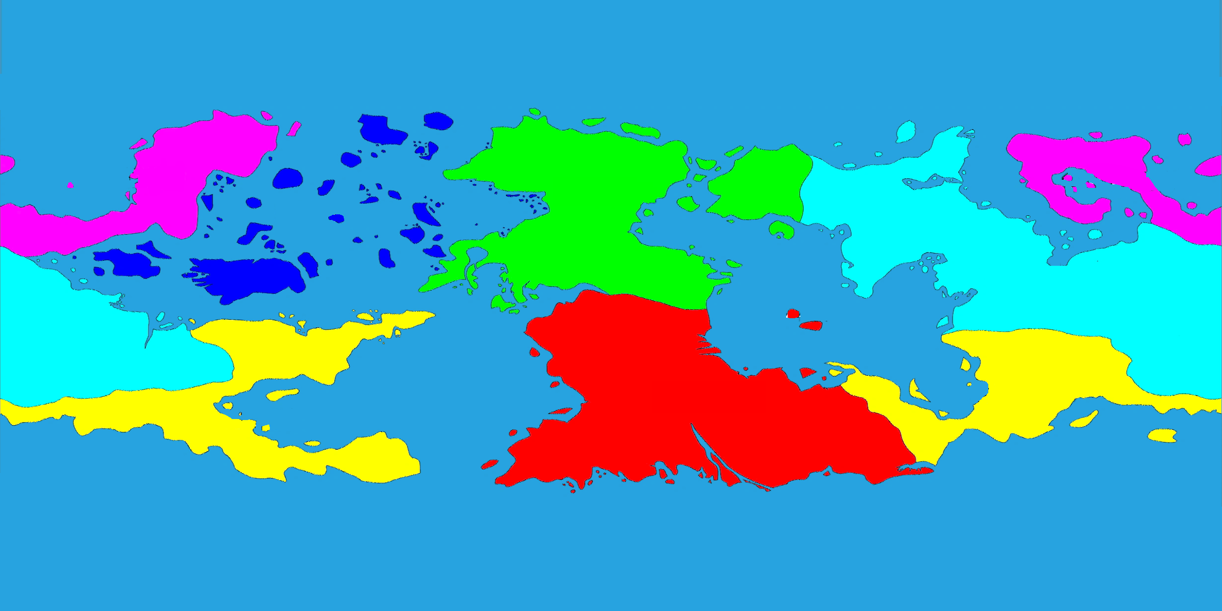
Below shows the 6 major continents of the world. As continents are commonly defined by their tectonic plates, I want this to be a guideline to how to determine where the tectonic plates should be. The 6 major continents
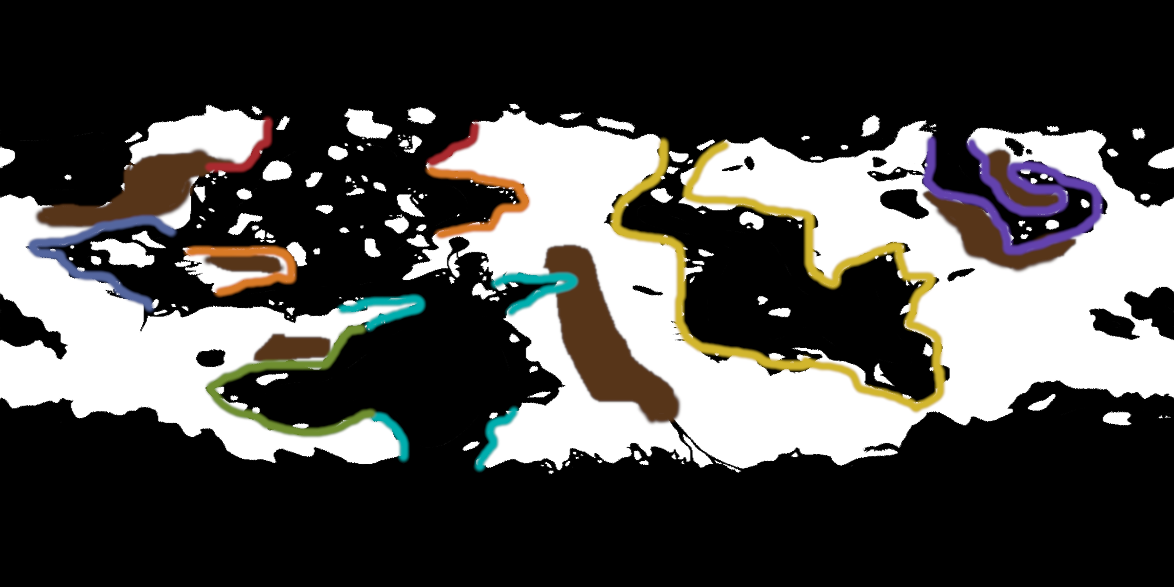
Below shows how the landmasses have fit together in the past. The color brown indicates regions of mountain ranges. The colors on the shorelines represent how other landmass fit together during the last supercontinent. How the landmasses fit together in the past.
Based on these two images, I want to decide where tectonic plates and their movement could have split the landmasses apart the way they are currently represented.

My previous research has helped me determine that divergent boundaries are usually between landmasses they are separating (forming mid-ocean ridges), and convergent boundaries are commonly at the location of mountain ranges. Although, these facts do not have to be a restriction.

Constraints: I don't want to change the continent division. I don't want to change the locations of mountain ranges. I also don't want to alter the landmasses at all.

Good answers will provide tips and/or resources that will help me decide where my tectonic plates should be. Please be descriptive and explain where plate boundaries should be and where they should not be, based on the data in these pictures.

EDIT: The planet depicted is an Earth-sized planet, and the landmasses shown in the images are all of the landmasses of the planet.

I have a world designed called Ser. I want to place tectonic plates so that they can explain how the current landmasses formed.

Below shows the 6 major continents of the world. As continents are commonly defined by their tectonic plates, I want this to be a guideline to how to determine where the tectonic plates should be. The 6 major continents

Below shows how the landmasses have fit together in the past. The color brown indicates regions of mountain ranges. The colors on the shorelines represent how other landmass fit together during the last supercontinent. How the landmasses fit together in the past.

Based on these two images, I want to decide where tectonic plates and their movement could have split the landmasses apart the way they are currently represented.

My previous research has helped me determine that divergent boundaries are usually between landmasses they are separating (forming mid-ocean ridges), and convergent boundaries are commonly at the location of mountain ranges. Although, these facts do not have to be a restriction.

Constraints: I don't want to change the continent division. I don't want to change the locations of mountain ranges. I also don't want to alter the landmasses at all.

Good answers will provide tips and/or resources that will help me decide where my tectonic plates should be. Please be descriptive and explain where plate boundaries should be and where they should not be, based on the data in these pictures.

EDIT: The planet depicted is an Earth-sized planet, and the landmasses shown in the images are all of the landmasses of the planet.

better described the images
Source Link
overlord
  • 6.3k
  • 2
  • 21
  • 55

I have a world designed called Ser. I want to place tectonic plates so that they can explain how the current landmasses formed.

Below shows the 6 major continents of the world. As continents are commonly defined by their tectonic plates, I want this to be a guideline to how to determine where the tectonic plates should be. The 6 major continents

Below shows how the landmasses have fit together in the past. The color brown indicates regions of mountain ranges. The colors on the shorelines represent how other landmass fit together during the last supercontinent. How the landmasses fit together in the past.

Based on these two images, I want to decide where tectonic plates and their movement could have split the landmasses apart the way they are currently represented.

My previous research has helped me determine that divergent boundaries are usually between landmasses they are separating (forming mid-ocean ridges), and convergent boundaries are commonly at the location of mountain ranges. Although, these facts do not have to be a restriction.

Constraints: I don't want to change the continent division. I don't want to change the locations of mountain ranges. I also don't want to alter the landmasses at all.

Good answers will provide tips and/or resources that will help me decide where my tectonic plates should be. Please be descriptive and explain where plate boundaries should be and where they should not be, based on the data in these pictures.

I have a world designed called Ser. I want to place tectonic plates so that they can explain how the current landmasses formed.

Below shows the 6 major continents of the world. As continents are commonly defined by their tectonic plates, I want this to be a guideline to how to determine where the tectonic plates should be. The 6 major continents

Below shows how the landmasses have fit together in the past. The color brown indicates regions of mountain ranges. The colors on the shorelines represent how other landmass fit together during the last supercontinent. How the landmasses fit together in the past.

Based on these two images, I want to decide where tectonic plates and their movement could have split the landmasses apart the way they are currently represented.

My previous research has helped me determine that divergent boundaries are usually between landmasses they are separating (forming mid-ocean ridges), and convergent boundaries are commonly at the location of mountain ranges.

Constraints: I don't want to change the continent division. I don't want to change the locations of mountain ranges. I also don't want to alter the landmasses at all.

Good answers will provide tips and/or resources that will help me decide where my tectonic plates should be. Please be descriptive and explain where plate boundaries should be and where they should not be, based on the data in these pictures.

I have a world designed called Ser. I want to place tectonic plates so that they can explain how the current landmasses formed.

Below shows the 6 major continents of the world. As continents are commonly defined by their tectonic plates, I want this to be a guideline to how to determine where the tectonic plates should be. The 6 major continents

Below shows how the landmasses have fit together in the past. The color brown indicates regions of mountain ranges. The colors on the shorelines represent how other landmass fit together during the last supercontinent. How the landmasses fit together in the past.

Based on these two images, I want to decide where tectonic plates and their movement could have split the landmasses apart the way they are currently represented.

My previous research has helped me determine that divergent boundaries are usually between landmasses they are separating (forming mid-ocean ridges), and convergent boundaries are commonly at the location of mountain ranges. Although, these facts do not have to be a restriction.

Constraints: I don't want to change the continent division. I don't want to change the locations of mountain ranges. I also don't want to alter the landmasses at all.

Good answers will provide tips and/or resources that will help me decide where my tectonic plates should be. Please be descriptive and explain where plate boundaries should be and where they should not be, based on the data in these pictures.

better described the images
Source Link
overlord
  • 6.3k
  • 2
  • 21
  • 55

I have a world designed called Ser. I want to place tectonic plates so that they can explain how the current landmasses formed.

Below shows the 6 major continents of the world. As continents are commonly defined by their tectonic plates, I want this to be a guideline to how to determine where the tectonic plates should be.As continents are commonly defined by their tectonic plates, I want this to be a guideline to how to determine where the tectonic plates should be. The 6 major continents

Below shows how the landmasses have fit together in the past. The color brown indicates regions of mountain ranges. The other colors represent how other landmass fit together during the last supercontinent. The colors on the shorelines represent how other landmass fit together during the last supercontinent. How the landmasses fit together in the past.

Based on these two images, I want to decide where tectonic plates and their movement could have split the landmasses apart the way they are currently represented.

My previous research has helped me determine that divergent boundaries are usually between landmasses they are separating (forming mid-ocean ridges), and convergent boundaries are commonly at the location of mountain ranges.

Constraints: I don't want to change the continent division. I don't want to change the locations of mountain ranges. I also don't want to alter the landmasses at all.

Good answers will provide tips and/or resources that will help me decide where my tectonic plates should be. Please be descriptive and explain where plate boundaries should be and where they should not be, based on the data in these pictures.

I have a world designed called Ser. I want to place tectonic plates so that they can explain how the current landmasses formed.

Below shows the 6 major continents of the world. As continents are commonly defined by their tectonic plates, I want this to be a guideline to how to determine where the tectonic plates should be. The 6 major continents

Below shows how the landmasses have fit together in the past. The color brown indicates regions of mountain ranges. The other colors represent how other landmass fit together during the last supercontinent. How the landmasses fit together in the past.

Based on these two images, I want to decide where tectonic plates and their movement could have split the landmasses apart the way they are currently represented.

My previous research has helped me determine that divergent boundaries are usually between landmasses they are separating (forming mid-ocean ridges), and convergent boundaries are commonly at the location of mountain ranges.

Constraints: I don't want to change the continent division. I don't want to change the locations of mountain ranges. I also don't want to alter the landmasses at all.

Good answers will provide tips and/or resources that will help me decide where my tectonic plates should be. Please be descriptive and explain where plate boundaries should be and where they should not be, based on the data in these pictures.

I have a world designed called Ser. I want to place tectonic plates so that they can explain how the current landmasses formed.

Below shows the 6 major continents of the world. As continents are commonly defined by their tectonic plates, I want this to be a guideline to how to determine where the tectonic plates should be. The 6 major continents

Below shows how the landmasses have fit together in the past. The color brown indicates regions of mountain ranges. The colors on the shorelines represent how other landmass fit together during the last supercontinent. How the landmasses fit together in the past.

Based on these two images, I want to decide where tectonic plates and their movement could have split the landmasses apart the way they are currently represented.

My previous research has helped me determine that divergent boundaries are usually between landmasses they are separating (forming mid-ocean ridges), and convergent boundaries are commonly at the location of mountain ranges.

Constraints: I don't want to change the continent division. I don't want to change the locations of mountain ranges. I also don't want to alter the landmasses at all.

Good answers will provide tips and/or resources that will help me decide where my tectonic plates should be. Please be descriptive and explain where plate boundaries should be and where they should not be, based on the data in these pictures.

Source Link
overlord
  • 6.3k
  • 2
  • 21
  • 55
Loading