5
$\begingroup$

I have a world designed called Ser. I want to place tectonic plates so that they can explain how the current landmasses formed.

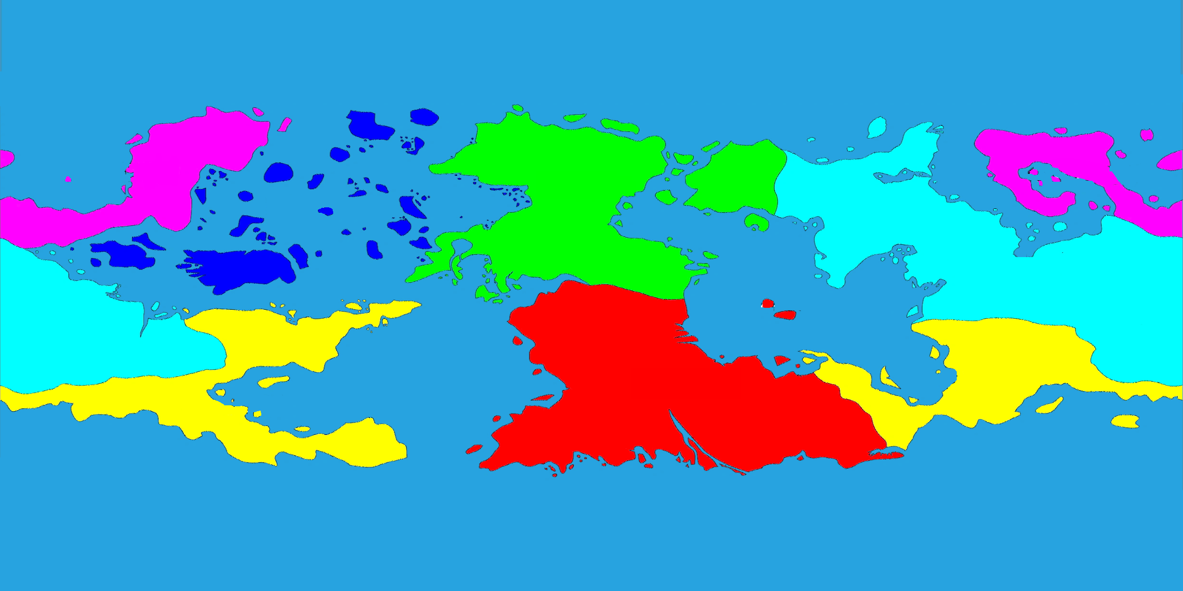
Below shows the 6 major continents of the world. As continents are commonly defined by their tectonic plates, I want this to be a guideline to how to determine where the tectonic plates should be. The 6 major continents
Below shows how the landmasses have fit together in the past. The color brown indicates regions of mountain ranges. The colors on the shorelines represent how other landmass fit together during the last supercontinent. How the landmasses fit together in the past.
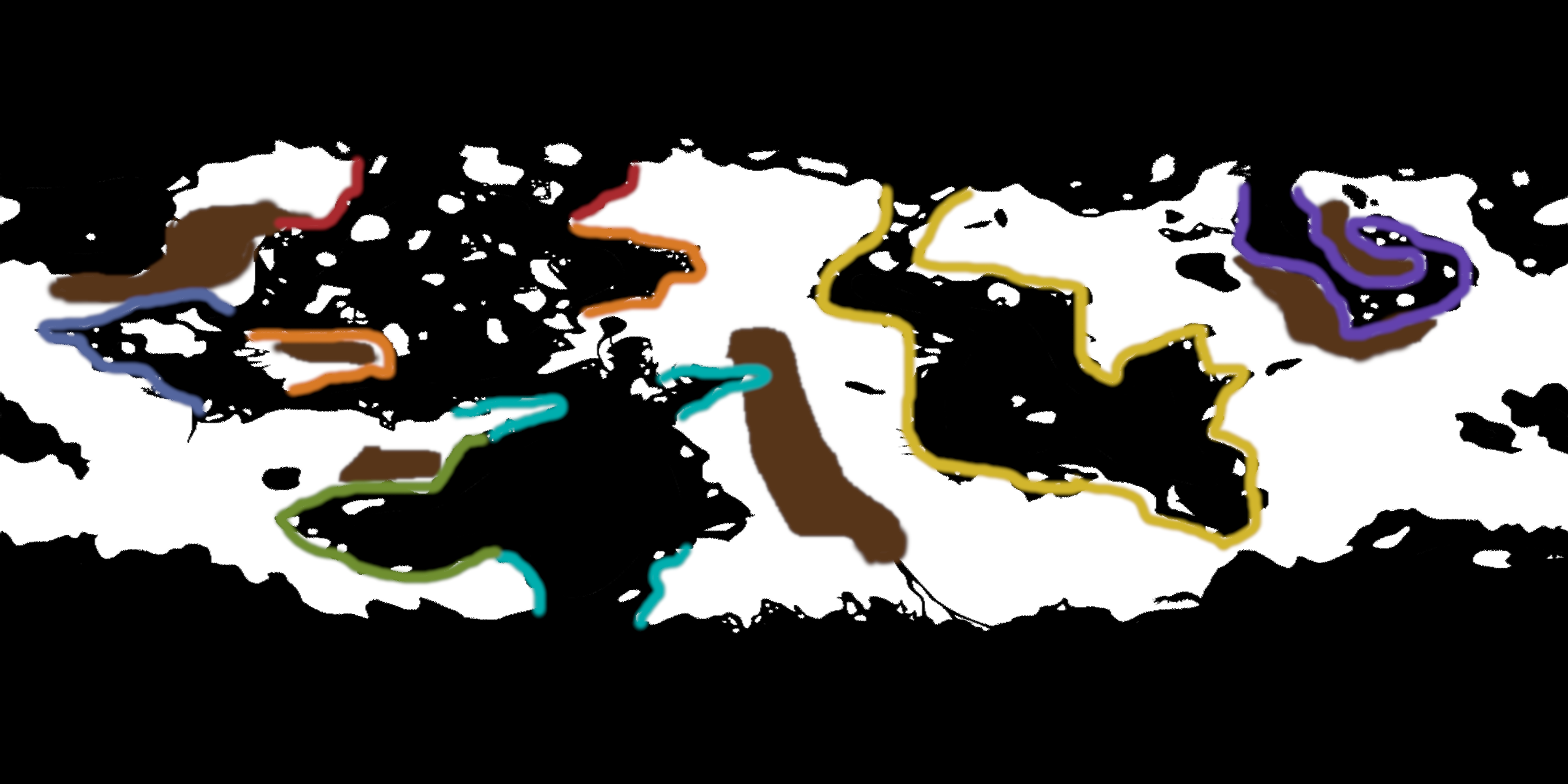
Based on these two images, I want to decide where tectonic plates and their movement could have split the landmasses apart the way they are currently represented.

My previous research has helped me determine that divergent boundaries are usually between landmasses they are separating (forming mid-ocean ridges), and convergent boundaries are commonly at the location of mountain ranges. Although, these facts do not have to be a restriction.

Constraints: I don't want to change the continent division. I don't want to change the locations of mountain ranges. I also don't want to alter the landmasses at all.

Good answers will provide tips and/or resources that will help me decide where my tectonic plates should be. Please be descriptive and explain where plate boundaries should be and where they should not be, based on the data in these pictures.

EDIT: The planet depicted is an Earth-sized planet, and the landmasses shown in the images are all of the landmasses of the planet.

$\endgroup$
8
  • 4
    $\begingroup$ What's the difference between the two pictures, other than the sea being black in the second one? It looks to me that they show pretty much the same arrangement of landmasses. (And what do the colored sea shores mean in the second picture?) (Convergent boundaries do indeed raise mountains, but they don't have to be that close to them; for example, the Alps are raised by the convergent boundary between the African and Eurasian plates, but the boundary passes through the Gibraltar and Messina straits, not near the shores of France...) $\endgroup$
    – AlexP
    Commented Sep 17, 2019 at 18:20
  • 1
    $\begingroup$ The colors on the shorelines represent how other landmass fit together during the last supercontinent. Kind of like how Eastern South America and Western Africa are very clearly "puzzle-pieces", even without any knowledge of plate tectonics. $\endgroup$
    – overlord
    Commented Sep 17, 2019 at 18:26
  • $\begingroup$ I only said they are "commonly" located at mountain ranges. I am not placing that as a restriction. $\endgroup$
    – overlord
    Commented Sep 17, 2019 at 18:28
  • $\begingroup$ There really isn't enough information in the pictures to give you useful ideas; for example, where are your mountain ranges? Do you know where you tend to have earthquakes? (Indicate where.) $\endgroup$ Commented Sep 17, 2019 at 19:03
  • 1
    $\begingroup$ @overlord Could you provide a blank black & white copy of your landmasses? I'd like to have a go at your tectonics. $\endgroup$ Commented Sep 17, 2019 at 20:55

1 Answer 1

13
$\begingroup$

You have a few problems

  1. Starting on the left, purple, you can't have a land mass between two places that were once joined,otherwise if you wind time back they can't join up because there is a land mass in the way.

  2. Pale blue, you can't form spikes like that,not as a plate to plate break. You can't have a sharp V shaped spreading center, crust breaks in 120 degree angles. The only way to get a narrow seaway is to have a spreading center in the center of it. and the only way to get a large acute peninsula is a subduction zone uplift, or multiple sequential spreading events in close proximity.

  3. You have way to many scattered large islands, if a landmass moved through someplace there can't be a bunch of large islands where it moved, it would have scooped them up. Islands are either so small they should barely show up on the map or they are chunks of continental crust, which means they need a whole plate pushing them along, they can't move over other plates moving other islands. You can have a few but not a whole mess of them and definitely not in a shotgun scattering, you can get a chain of islands on a subduction zone but that s what shape they will take a subduction arc (Alaska or Japan), or two subduction arcs coming from two directions for earth (Oceania). And you will not have many between two landmass boundaries that were once joined, there is no way to get them there.

  4. On the right the purple spiral is a mess, you can't have a divergent boundary between two mountain ranges, a spreading center will not form on thickened crust, spreading centers form where the crust is weak and thin, they are literally breaks in the crust and a material is not going to break at its strongest point.

  5. Looking at the map overall you also can't have nothing but divergent boundaries, every sea you have is bordered by land masses that were joined, that can't happen unless your planet is actually getting bigger. crustal material has to go somewhere, if it is being forming in one place it has to be getting subducted somewhere else an the same axis, otherwise the diameter of the planet along that axis is getting bigger. You can get a away with some minor ones because your looking a two dimensional representation of a spherical surface but they need to be more hinge like (dead ended) so rotation is happening. I considered running a continent to continent convergent boundary down hte middle of your central continent but it is too small to support that, one of the oceanic plates would just give way and start subducting, the Himalaya only exist because Asia is huge and India is small yet close to its spreading center.

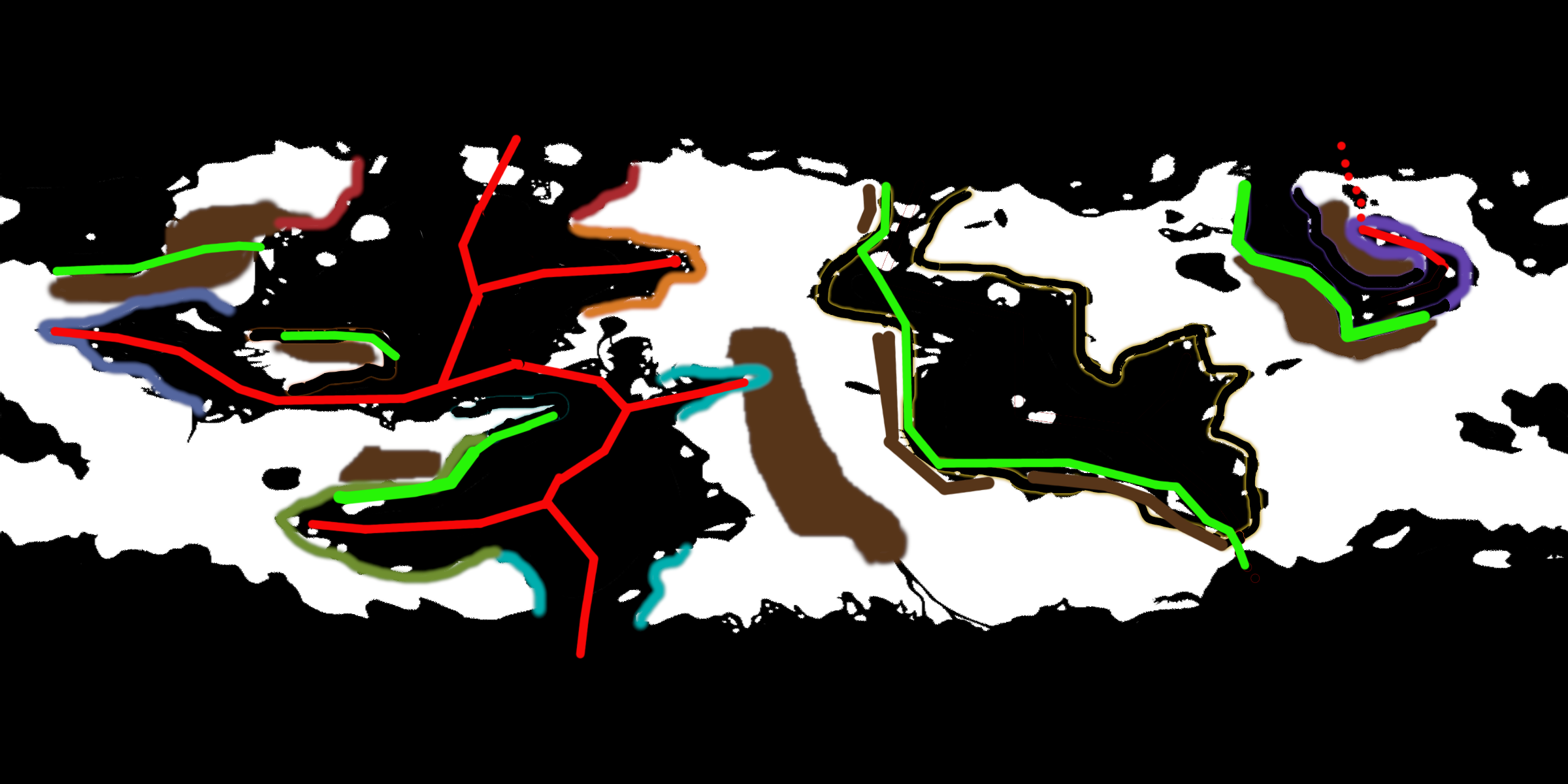
I have done my best with your map while trying to change as little as possible. Spreading centers are marked in red and subductions zones marked in green. If two places can't be areas that were once joined I have erased the matching colors. Islands that I just couldn't justify no matter how much a stretched I just erased. I added a mountain range near the yellow coastline because subduction zones create mountain ranges, and putting the subduction zone there disrupted less of the map than anywhere else.

I have just ignored your first image because it makes no sense, they look like political borders not tectonic ones.

enter image description here

Really you would be better off starting over from scratch, it will look a lot more convincing. Or at least you have to do some serious editing of your map to make something possible. You have too much land in the mid & low latitudes and too many random islands.ideally you could even take a bug chunk out of a continent to open up some room for things to move.

The best way to build a map is to start with rough idea of what you want and work progressively towards it instead of taking a finished map and asking how to fix it (and that is what you are asking whether you intend to or not). I know you don't want to change anything but you just can't make something believable from what you have without changing it. Sometimes the answer is "you can't get there from here". You can't add in techtonics after the fact, techtonics are what creates landform.

The quick and dirty way to map spreading centers is just make a line in the center of the ocean that roughly matches the coastline wherever you have two coastlines that match. Spreading centers are not always centered but they most often are. You need large subduction zones to move them away from center. if you have two parallel spreading centers you either need a subduction zone between them or one on each side, again crustal material has to go somewhere. Mountains are formed by convergent plate boundaries, sometimes they are old plate boundaries but if mountains are near the coast that is usually due to an active subduction zone, hence why I put your subduction zones near existing mountains whenever possible.

$\endgroup$
12
  • 1
    $\begingroup$ This is not dissimilar to what I'd do with that arrangement of continents. The big inland sea on the centre-righthand part of the map reminds me a lot of the Mediterranean. I think it should definitely be a closing basin, perhaps even more complex that you've drawn it there. $\endgroup$ Commented Sep 17, 2019 at 20:54
  • 2
    $\begingroup$ @overlord Under no circumstances can an asteroid do that and leave the surface of the planet unmelted. On the timescales of a sudden event like that, plates are immobile, and the mantle underneath is a static solid mass. What you are asking for amounts to a crash course in the entire subject of plate tectonics, rather than a single question with a single best answer which is what this website requires. Furthermore, I think you may have to accept that your continents are not very realistic, and thus shoehorning tectonics into your map is, as a result, not going to be very realistic either. $\endgroup$ Commented Sep 18, 2019 at 1:48
  • 3
    $\begingroup$ @overlord, I did explain actually but I will add more clarification. and asteroids don't move plates, they don't even break them, an asteroid large enough to do either just re-liquefies the planet. $\endgroup$
    – John
    Commented Sep 18, 2019 at 4:59
  • 1
    $\begingroup$ @Zavael you don't have to go that far, you can start with something like I want a big continent here, a smaller one here a bunch of islands here,you can build a map with a goal in mind but you can't start from a finished detailed product. $\endgroup$
    – John
    Commented Sep 18, 2019 at 13:47
  • 2
    $\begingroup$ @overlord I suggest posting a new question, with a blank map, without even mountains. note you will still have an issue with the scattering if islands in the north eastern ocean, they key part of archipelago is the "Arch" part, volcanoes can't just create any shape. they layout of the islands is still determined by plate motion. $\endgroup$
    – John
    Commented Sep 18, 2019 at 14:28

You must log in to answer this question.

Not the answer you're looking for? Browse other questions tagged .