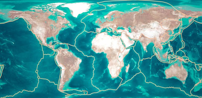
One of the continents in the map I’m working on has a transform plate boundary that forms a fault line. How should I draw this fault line on the final map? I’ve looked at the San Andreas fault line, but I can’t think of something that would work with the “fantasy” style of mapmaking that I use.
-
2$\begingroup$ When you say "how do I draw" do you mean "how do I represent" or "how do I decide its way of deploying through the continent"? $\endgroup$– L.Dutch ♦Commented Dec 22, 2021 at 5:31
-
$\begingroup$ Could you give us an example of the artwork or the geography, it's a bit unclear what you're asking at present. I always thing of Middle Earth or Pern as a frame of reference, the fault lines aren't really delineated, but you can perhaps deduce a few from the landscape, what sort of style of approach are you taking? $\endgroup$– Escaped dental patient.Commented Dec 22, 2021 at 6:54
3 Answers
Maybe just don't? We didn't discover fault lines until the late 1800's, well into in the industrial era. I would recommend that fault lines remain strictly for your reference, not an element of your final map that would reflect how people in your setting understand their world. As for drawing them for your personal reference, I just draw the rough shape of the individual continental plates.
If I'm misunderstanding and you want an industrial-era map with fault likes in a fantasy style, though, I would say this just comes down to personal style truly. Maps showing topographical data like fault lines usually aren't very stylized, and I don't see why this would be much different in a fantasy setting. Though, I guess if you really wanted to, you could do something like this?

-
1$\begingroup$ Okay, I think I’ll do that then, and just keep them for my own reference. Thank you! $\endgroup$ Commented Dec 22, 2021 at 7:12
-
$\begingroup$ @villain_l no problem! glad i could help ^^ $\endgroup$– INPUCommented Dec 23, 2021 at 8:41
Imply faults with elongated waterways.
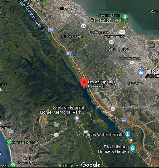
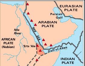
Faults can create valleys and sometimes these fill with water. Very elongated bodies of water can suggest the presence of an underlying fault. Examples:
Crystal springs reservoir along San Andreas fault. San Andreas lake clearly is along the same line and a neat idea for your map - several small waterways tracing the same fault.
The Red Sea is the Crystal Springs reservoir writ large. Gulf of Aden and Persian Gulf are less crisp but are where they are because of the same principle.
If you need to label faults on your map then I guess you will draw a line and label it, same as for a river or a road. If you want the landforms to imply a fault you can use bodies of water to do that.
-
1$\begingroup$ This, 100%. There is no need to show the actual fault line, just as there is no need to show any other plate boundary. It is, however, useful to know where these boundaries lie in order to make a geologically realistic map. The best way to suggest the existence of a fault line is to show what impacts it has on the land itself. $\endgroup$ Commented Dec 22, 2021 at 17:49
Consider not drawing it as a fault line, but rather...
- as a magical lay line with arcane runes surrounding it
or
- as the long serpentine body of a slumbering dragon, similar in style to the sea-serpent drawings on old mariners charts with ledgers like "hic sunt dracones" (here be dragons).
In either case, the lines should serve as warnings to the magically gifted. Be careful casting near these places lest you wake magic/monster below.
-
1$\begingroup$ I think you could expand this to more than just superstition. There could easily be some magical connection with the earth that makes physical geologic structures have a real impact. Even if its something as simple as knowing geologic weak points (faults being the weakest of them) that can be exploited when using earth magic. $\endgroup$ Commented Dec 22, 2021 at 17:53


