30
$\begingroup$

I was looking through a bunch of different ways we can shape a map of the Earth and it got me thinking. We map out planet as a stretched rectangle with NSEW as Up Down Right Left, with the Equator right in the middle. But what would cause a species to prefer a different way of mapping?

Tidal Locking may cause a species to develop a map for each hemisphere. Maybe they would focus more on the positions of extreme weather conditions. What would cause other unique ways of mapping a planet?

Edit: I’m specifically looking for 2D maps not 3D maps like globes.

$\endgroup$
20
  • 11
    $\begingroup$ There are two conventions at work: 1) Importance: Human psychology and egocentrism - the mapmakers put themselves at the center or near the top because other humans recognize those locations as important. 2) The apparent closeness of Geographic North Pole (axis of rotation) and Geomagnetic North Pole, making North an important direction to navigators. Your aliens simply need a different psychology, or different locations for the magnetic poles, or simply don't use compasses. $\endgroup$
    – user535733
    Commented Sep 21, 2019 at 19:39
  • 17
    $\begingroup$ Back in the old days our maps did not follow those rules, so it is not as if those rules are universal even to men. In any case, remember that any representation of a sphere on a plane is always imperfect (although for small patches of the surface of the sphere it can be good enough). Maybe the aliens have the technology to use spherical maps and need the precission. $\endgroup$
    – SJuan76
    Commented Sep 21, 2019 at 19:58
  • 27
    $\begingroup$ "We map out planet as a stretched rectangle" ... except when we don't. And very often we don't. $\endgroup$
    – AlexP
    Commented Sep 21, 2019 at 22:52
  • 5
    $\begingroup$ Your aliens may have no eyes and use echo-location instead, then the map will be a mosaic of pieces made of different materials with different sound reflection ability. Oh, but what if they have infrared themographic vision?... $\endgroup$
    – Yellow Sky
    Commented Sep 22, 2019 at 0:22
  • 17
    $\begingroup$ Obvious Framing Challenge: There is no single traditional way of mapping the Earth, there are many different ways, no one way was ever the dominant way, nor considered the "traditional" way. $\endgroup$ Commented Sep 22, 2019 at 16:15

19 Answers 19

42
$\begingroup$

It's very much a matter of what information they want to display in their primary 3d to 2d projection.

The Mercator projection that everyone is so familiar with is simply designed so that lines of latitude are straight horizontal and any simple compass bearing is a straight line. This makes ocean navigation easier as the important factor was knowing how many degrees north or south you needed to be.

The Mercator projection (/mərˈkeɪtər/) is a cylindrical map projection presented by the Flemish geographer and cartographer Gerardus Mercator in 1569. It became the standard map projection for navigation because of its unique property of representing any course of constant bearing as a straight segment.

Any minor details like distances or areas of countries can be neglected, that's not what this particular map projection is for. The reason north is at the top and the prime meridian goes through Britain is because the British cartographers made the best maps and they chose such a layout. There's also McArthur's corrective Mercator projection that puts Australia top centre and it looks really strange to the rest of us.

If you go far enough back in history, you'll find maps with Jerusalem at the centre, but they're not particularly useful.

What you have to do is define what it is that your map is supposed to show accurately and what can be sacrificed in turn.

Say that the primary empire of the early industrial period was landlocked, now ocean navigation isn't a defining factor but rather land distances from the capital. Now you have a map that has the imperial capital in the centre and uses something like Azimuthal equidistant projection which preserves the distances from the centre.

The azimuthal equidistant projection is an azimuthal map projection. It has the useful properties that all points on the map are at proportionally correct distances from the center point, and that all points on the map are at the correct azimuth (direction) from the center point. A useful application for this type of projection is a polar projection which shows all meridians (lines of longitude) as straight, with distances from the pole represented correctly.

This map isn't great for travelling to or from anywhere other than the centre point, but as they say, all roads lead away from Ankh-Morpork*. Perhaps regional cities would have their own local map with the city in the centre allowing local navigation.


*Sometimes people go along them the wrong way.

p.s. Somehow we overlooked the mandatory xkcd

$\endgroup$
7
  • 3
    $\begingroup$ Indeed, there's at least a few medieval maps out there that plunk Jerusalem right in the middle, for a real world example $\endgroup$
    – Pingcode
    Commented Sep 22, 2019 at 2:32
  • 18
    $\begingroup$ The Mercator projection is not the only one to represent the parallels as straight horizontal lines. Far for being the only one. But it is the only projection where all loxodromes are represented as straight lines, which was quite important for navigation before the advent of satellite based positioning systems. It is also a conformant projection, meaning that small objects are represented in their true shape, which is also quite important. $\endgroup$
    – AlexP
    Commented Sep 22, 2019 at 11:52
  • 10
    $\begingroup$ Ankh-Morpork isn't the best example, since the world it inhabits is literally flat. (It's even called "Discworld".) So a simple flat projection map would obviously be ideal in that world, since it actually is flat. You wouldn't have any of the problems with distortion in area or direction or distances that we necessarily get mapping a sphere onto a 2D surface. $\endgroup$ Commented Sep 22, 2019 at 17:58
  • 2
    $\begingroup$ @DarrelHoffman, all roads lead to Rome, but I always prefer the Pratchett quote if there's a suitable one. Also the azimuthal equidistant projection maps a globe onto a circle, so it's not that far out of place. $\endgroup$
    – Separatrix
    Commented Sep 23, 2019 at 8:05
  • 2
    $\begingroup$ "and what can be sacrificed in turn" Indeed, a fair number of sociopolitical assumptions are created and/or reinforced by maps, as mentioned by a well-known scene from The West Wing. Your aliens would have similar assumptions built into their own maps. $\endgroup$
    – Ti Strga
    Commented Sep 23, 2019 at 18:33
39
$\begingroup$

Bizarre real maps

In our real world of the planet Earth, some traditional cultures created maps that for most people would look absolutely like alien objects and will not be recognized as being actually maps, still the are maps, and they are of practical use.

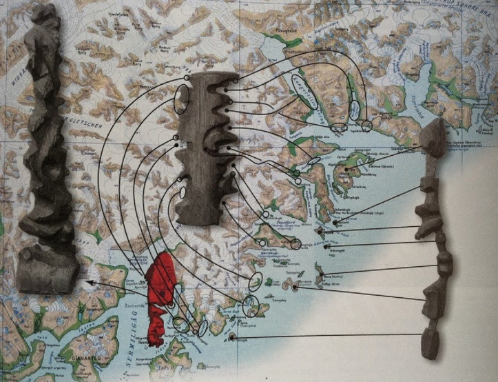
Inuit wooden maps

enter image description here

The Inuit people of Greenland used carved pieces of floatwood to depict the coastlines (Inuits live along coastlines). The maps are compact, buoyant, and can be read in the dark. Here is a couple of examples.

Micronesian stick chart

enter image description here

Micronesian stick charts show wave patterns and currents. The shells represent atolls and islands. Using stick charts (also called rebbelibs, medos, and mattangs) ancient mariners successfully navigated thousands of miles of the South Pacific Ocean without compasses, astrolabes, or other mechanical devices.

The charts aren't made of sticks. Most stick charts are made of coconut fiber and shells. Placement of the fibers and shells indicate the location of islands, waves, and currents.

$\endgroup$
7
  • 10
    $\begingroup$ Except here's the thing: as soon as paper became available, Inuit went for standard style maps just like everyone else did. (Inuit is plural, by the by: the singular is Inuk. There is no word "Inuits".) The examples you've shown work until you reach the level of papermaking and printing, or have access to supplies of it. $\endgroup$ Commented Sep 22, 2019 at 18:06
  • 7
    $\begingroup$ @KeithMorrison - So what? We now don't use paper maps anymore, since GPS became available, and in future we probably won't use GPS either, and the global map will be implanted into the brain at birth. My point is that some time ago those old maps were used, and obviously for centuries. Your comment is irrelevant as for the question discussed. $\endgroup$
    – Yellow Sky
    Commented Sep 22, 2019 at 18:20
  • 4
    $\begingroup$ @OlegV.Volkov that's actually not true. You can apply any projection to a GPS map, chosen at runtime. With paper maps you're stuck with whatever projection was deemed best by the author. This makes GPS maps slightly unintuitive for paper map users, especially if the previous user of the same device liked to view their map with north to the left because then their home city fit better on the screen, or if they really wanted to take a close look at that one detail on the satellite photo and didn't bother to switch back to a normal scale afterwards. $\endgroup$ Commented Sep 23, 2019 at 13:01
  • 2
    $\begingroup$ @JohnDvorak you've just described turning paper map around in your hands and bringing it closer to the eyes or looking at fine details with hand magnifier. Yes, it is more convenient on screen, but hardly some "new concept" to paper map user. $\endgroup$ Commented Sep 23, 2019 at 16:02
  • 2
    $\begingroup$ @Yellow Sky: Who are you calling "we"? GPS is good for locating positions, not so good as a map. If nothing else, have you ever found a GPS device (or any phone, tablet, &c) that's actually readable in sunlight? Paper maps are still much better for many uses. $\endgroup$
    – jamesqf
    Commented Sep 23, 2019 at 17:39
27
$\begingroup$

Maps don't have to be geographical, they can also be diagrammatical, like the London Tube map. For instance, ancient Roman maps, the itinerarium, were graphs showing points of interest along a road rather than geographical relations. A branch in the road was a branch in the graph line.

Another approach is symbolic maps, like the medieval T-O maps and mappa mundis. The simplest of such are extremely abstract, but at the other extreme, you could have more detailed ones as well, like the one at Hereford Cathedral. These maps are constructed the way they are to fit the prevailing religious worldview of the time.

$\endgroup$
1
  • 1
    $\begingroup$ Some tribes on earth have used grids of sticks and stones. Even a mesh of string with beads could be used and only works if held open from the correct 3 places to protect information from spies. $\endgroup$
    – KalleMP
    Commented Sep 22, 2019 at 11:27
15
$\begingroup$

The aliens did not evolve on the surface

These aliens evolved from ant/bug/worm-creatures, possibly moles if you want a more mammal origin. They never cared about how the surface looked, and only cared about 3D connectivity and branching. It's likely that they couldn't even see.

In the beginning their maps were made out of knotted straws, where knots indicates a larger hollow or other points of interest, and branching was made by tying another straw. This would be superficially similar to our quipu used for bookkeeping. If the map had to be more accurate it had to be made out of something stiffer, like twigs or roots, so that directions such as up/west/east could be recorded.

Surface points would be marked in a way to show the type of environment around it: field, rocky, woods, close to water, etc.

The version made out of straw would be portable because you can just fold it down to a small ball, and keep the relevant sections unfolded. This would of course require training and maybe special equipment to keep it from tangling.

Move to the surface

When this race started caring about the surface of the whole planet, the maps would still be made in the same way as had been previously done: folded straw/twig sections, the more advanced the society got, the more advanced materials could be used, and portable maps would be intricate jointed constructions automatically folded by small machinery.

However, they had never needed anything flat to write on and it would never occur to them to ever make a 2D projection of something that was not 2D from the beginning - especially since they don't rely on vision.

Forced 2D projection

Even though you want a classical 2D projection, this would be unnatural for these guys and would probably only be constructed for trading purposes with other species. This map would only contain points-of-entry to the rest of the 3D network, and they would have no real concept of "projection", so the map would very likely be divided into sections sized so that the curvature would not cause too much of a distortion, and then these sections would be printed out next to each other. Think of hexagons or square tiles. The closest system I could find today is the "interrupted Goode homolosine projection":

Goode homolosine projection

It would probably not have any borders at all, just point clusters - the different nations would just be separate sections, with textual descriptions on how the pieces should fit together.

$\endgroup$
3
  • 2
    $\begingroup$ I want some Bermuda shorts with this printed on it. $\endgroup$
    – KalleMP
    Commented Sep 22, 2019 at 11:32
  • $\begingroup$ I like this a lot. When thinking about my answer I was still stuck with the idea that the map should be 2D, and tried to compress a dimension other than the usual one. For a truly 3D society that won't do. $\endgroup$ Commented Sep 22, 2019 at 13:45
  • 1
    $\begingroup$ I find it funny how much this map bends over backwards to keep Americas on the left $\endgroup$
    – Andrey
    Commented Sep 26, 2019 at 15:09
11
$\begingroup$

If you're dealing with cartological evolution, the answer is "pretty much nothing."

I suspect all species would develop maps in the following way:

  1. They sit down with a stick and some rocks, draw the local river, put some rocks in to mark the villages, then in their own language intone the words, "grog, you take bugga and clobber dis place. Me take Wherk and pound over der."

  2. A little while later, something akin to paper/vellum/papyrus is invented, and the conversation goes something like, "Hermicules, thou taketh thy holy troops and stand atop the Hilltop of Crahakia the Elder and then shalt thou count to three, no more, no less. Three shall be the number thou shalt count, and the number of the counting shall be three. Four shalt thou not count, nor either count thou two, excepting that thou then proceed to three. Five is right out! Once the number three, being the third number, be reached, then thou shalt assault the city in the name of Daiphus and bring salvation to the wicked!"1

  3. A little later, someone discovers a rock, or a pin, or something on a leaf, that happens to point in a useful direction in a predictable way. Such a person might suggest that direction to be "Gorp!" Thereafter, the "top" of the page upon which the battle plan holy consecration is thus inscribed is known as "Gorp!"2

  4. And sometime after that subways are invented and some genius figures out that actually knowing the geography involved with cartography isn't actually relevant or practical when it comes to dropping down to the corner to buy a box of smokes.

My point is, cartography inevitably starts with a 2-D rendering of the local geography and becomes more complex as more data needs to be represented, but there are only so many ways simple geography (the local river, hill, and village) can be represented unless your aliens don't have eyes.

An advanced species may have a reason for not using what Humans use today, but how they came to the threshold of that decision is, IMHO, highly unlikely to be any different than Humanity experienced.

Remember, knowledge is a pyramid, ever growing in size, and your aliens are at any given moment standing atop their pyramid. However, in the beginning, that pyramid is very small, and that means very little variation compared to any other sapient species.

IMHO.


1My undying thanks to Monty Python for one of the most enduring and funniest moments of dialog in history.

2It's worth noting that step #3 might come before step #2. It's a bit wishy-washy in the middle.

$\endgroup$
6
  • 6
    $\begingroup$ #1 does not hold for cave-digging critters (ant/worm/bug-aliens) since you need a "volumetric" representation from the start $\endgroup$
    – pipe
    Commented Sep 22, 2019 at 9:01
  • 1
    $\begingroup$ @pipe that could be developed into an answer $\endgroup$
    – lijat
    Commented Sep 22, 2019 at 10:54
  • $\begingroup$ @lijat Already started when you wrote that comment. :) $\endgroup$
    – pipe
    Commented Sep 22, 2019 at 11:09
  • $\begingroup$ @pipe It still follows the same principle - you describe the topology of clearly visible things. Rivers, hills, rock types, roads... These kinds of maps didn't allow you to judge distances (and in particular, the shortest paths between two places, area etc.), but they worked fine for finding your way. A lot of the border disputes between medieval states hinged on this - when the river shifted, the one who gained territory claimed the change should be accounted for, and the one who lost argued against. And suddenly, one claimed a whole province of another state :D $\endgroup$
    – Luaan
    Commented Sep 23, 2019 at 11:28
  • 1
    $\begingroup$ @pipe For a primitive navigation aid for ant-aliens, you could imagine something like old school 2.5D game engines - a flat 2D map that maps out the topology, but doesn't try to form a "flat" 3D world - just the connections between individual tunnels. Later, you add proper distances and depths, and you still get a nice flat topological map, but are able to better estimate distances, and figure out where to dig that new tunnel between the two old tunnels. In fact, we routinely use such "maps" for multi-dimensional data where we care mostly about the connections. $\endgroup$
    – Luaan
    Commented Sep 23, 2019 at 11:31
8
$\begingroup$

Population distribution and travel means

As others ponted out, math says that a perfect map is impossible. The aliens have to pick what they really care about.

We chose that projection because nobody lives at the poles. If your world is, say, not inhabitable except at the poles maps will be different. Maybe all known maps cover just part of it because the other half is all but impossible to explore.

Technology is also a factor. In the age of exploration, on Earth, traveling by sea was way better (cheaper, faster) than over land. This made sailing crucial, so maps that had a bad representation of the oceans were impractical. If the alien civilization had different areas of interest and different ways to move around (and tell where they are) things might be different.

Note: There are polar bases now and also in the past there have been populations living in places like Siberia or northern Canada. The fact is that when our map projections consolidated in the past centuries those regions were considered of little interest.

$\endgroup$
4
  • $\begingroup$ Used to be true, but not anymore: The South Pole Station has been inhabited year-round since the 1950's. North Pole is a bit harder, but Santa makes do... $\endgroup$ Commented Sep 22, 2019 at 18:07
  • $\begingroup$ It was true when standard projections consolidated, centuries ago $\endgroup$
    – Rad80
    Commented Sep 22, 2019 at 18:09
  • 4
    $\begingroup$ Good point. An example of different approach is Frank Herbert's Dune, where only the polar regions have permanent habitation so we only get two azimuthal maps of inhabited areas. $\endgroup$
    – Milo Bem
    Commented Sep 23, 2019 at 9:04
  • 1
    $\begingroup$ Another good example is Brandon Sandersons' original Mistborn trilogy. The planet was warmer, hence only the poles were habitable. $\endgroup$
    – Gloweye
    Commented Sep 24, 2019 at 13:37
6
$\begingroup$

The math of projecting the surface of a 3D sphere to a 2D piece of paper is well studied, and the main solutions together with their strengths and shortcomings have been discussed. So let's go with something different.

What if for this culture altitude information is more important than either E/W or N/S direction?

Imagine an avian species living on a steep hillside following a ridge. For the purposes of their surroundings the two relevant dimensions would be the distance to a point of reference along the ridge, and elevation above the bottom/sea level/whatever.

Sure, the laws of planetary physics/geography make it unlike that the hillside would be a totally vertical cliff, but if the incline is steep enough, there would be relatively little variation in the distance from the ridge. Much like relative flatlanders such as yours truly don't really pay much attention to the elevation above the sea level of their whereabouts. For example, assume the ridge is running N/S. Such a community would surely have more use for a map where locations are marked using N/S distance to a reference point (gubernatorial center) and elevation.

Highly evolved razorbills or puffins on a scaled up Látrabjarg.

$\endgroup$
8
  • $\begingroup$ If altitude is important, a topographical map. Shows steepness of terrain and altitude. Colour is optional. $\endgroup$ Commented Sep 22, 2019 at 18:02
  • 3
    $\begingroup$ @KeithMorrison I had in mind a small "area", where all the places have the same E/W coordinate, and only altitude and N/S are meaningful in telling one place from another. A vertical or a nearly vertical "town", where altitude is NOT the coordinate you want to "lose" in a projection to 2D. $\endgroup$ Commented Sep 22, 2019 at 18:13
  • $\begingroup$ @KeithMorrison, if you've got an avian species, your primary navigation map probably isn't going to be a topographic map, it's going to be a profile map showing elevation change along a flight path. $\endgroup$
    – Mark
    Commented Sep 23, 2019 at 21:15
  • $\begingroup$ @Mark, that works fine if you limit your flight paths. If your flights are more free ranging than your profiles start combining...into a topographical map. $\endgroup$ Commented Sep 23, 2019 at 22:50
  • 1
    $\begingroup$ @JyrkiLahtonen, if everything they need is along that cliff, than it's not an issue: a simple 2D map with one axis going along the ridge, the other going up and down. However, puffins and razorbills don't live their whole lives on that cliff. They range around, and thus a map is going to have to be much more extensive. $\endgroup$ Commented Sep 23, 2019 at 22:52
6
$\begingroup$

The aliens know some mathematics that we don't.

In the question, there is mention of a particular rectangular projection, best known as the Mercator projection. However, there are many other ways we Earth people have figured out for projecting a sphere onto something flat, including conic, conformal, gnomonic. There is a decent article at Wikipedia.

Each of these projection techniques requires an understanding of some type of geometry, trigonometry, or related areas of mathematics, and there could easily be other possible projections we have yet to discover, but the aliens have known for a long time. Their maps won't be radically different as a result, but perhaps just different enough to handwave it into your story.

$\endgroup$
4
  • 1
    $\begingroup$ In addition to the Wikipedia article, there's a list of map projections - with images and simple highlights of each projection strengths and shortcomings. $\endgroup$
    – G0BLiN
    Commented Sep 22, 2019 at 11:06
  • $\begingroup$ Yeah, they map the imaginary axis to create interesting transforms that compensate for magnetic field strength or dip angle. $\endgroup$
    – KalleMP
    Commented Sep 22, 2019 at 11:28
  • $\begingroup$ Pretty much all maps require the same math. $\endgroup$
    – Rad80
    Commented Sep 23, 2019 at 11:29
  • 2
    $\begingroup$ There are many, many projections that have been thought of and used in mathematics that do not show up in that list. The reason for that is these projections make lousy maps. The projections you see listed were created not because we happen to know the math behind them, but rather because we started with some idea of what we wanted to preserve and then figured out the math that would best preserve it when projected onto a plane. Aliens would only produce different projections if they had something different they wanted preserved on their maps. $\endgroup$ Commented Sep 23, 2019 at 17:48
4
$\begingroup$

We project our world on a bi-dimensional surface because we learned to make flat surfaces well before making spheres.

And don't forget that you can easily cut a flat surface in smaller pieces, while cutting down a sphere is more difficult. In other words, if you don't need the whole world but just the 1000 km around the Republic of San Marino, it is more easy to do it on a flat surface than on a sphere.

Moreover, flat surfaces can be more easily carried around and stored. A map can be rolled up, a ball will stay a ball.

Change those factors above and you will have a different outcome with respect to map making.

$\endgroup$
7
  • $\begingroup$ I'm sure a ball can be rolled up, too, just deflate it. Or if it's solid, it can be rolled up into the fourth dimension. $\endgroup$
    – Yellow Sky
    Commented Sep 21, 2019 at 20:18
  • 3
    $\begingroup$ @YellowSky, we learned to use bark and skin way before we learned how to make an inflatable ball. And we still don't know how to roll something in the 4th dimension. If you do, please give me the instructions to do it. $\endgroup$
    – L.Dutch
    Commented Sep 21, 2019 at 20:21
  • $\begingroup$ Aren't we talking about aliens here? They may well be able to do that. Besides, we the people of Earth, have known how to roll things into the 4th dimension for quite a long time already, we just cannot practically do it, yet. The mathematical theory of four-dimensional space was precisely formalized in 1854 by Bernhard Riemann. The instructions are in that Wikipedia article. $\endgroup$
    – Yellow Sky
    Commented Sep 21, 2019 at 20:36
  • 2
    $\begingroup$ @YellowSky In the context of this answer, "have a mathematical representation for X" and "know how to do X" are not remotely the same thing. $\endgroup$
    – G_B
    Commented Sep 22, 2019 at 3:35
  • 1
    $\begingroup$ @Jeff, read Abbott's Flatland and say that again. What you state is the same as the "above, but not up" mentioned there. $\endgroup$
    – L.Dutch
    Commented Sep 22, 2019 at 9:53
4
$\begingroup$

The geography of the alien planet can be very different from ours. Imagine a water world with just a single continent centered on one of the poles, like our Antarctica, with no other continents, not even islands. In this case, they wouldn't just need to map the other water-only hemisphere, and their maps will be of round shape with the pole in the center.

Or the planet can have the shape not near-spheric like the Earth's, but of irregular shape, for example it had a heavy collision with another object that deformed it. In this case, the projection of the planet's shape on a flat surface can take rather weird shapes, the ones that cannot fit effectively into a rectangle, or the planet can have even not two, but three or more "hemispheres", so where we have the map of two round hemispheres, their map will have four triangular ones.

We can go on imagining different geographies and different planet shapes with their respective maps. I'd love to see a map of a planet which has tunnels going through the core as wide as to allow the aliens to live not on the outer surface of the planet, but on the inner surfaces of the tunnels, too.

$\endgroup$
7
  • 1
    $\begingroup$ FWIW, any planet capable of sustaining surface water (which requires a thick atmosphere for pressure) would collapse back to a spheroid after a collision due to self-gravity. $\endgroup$
    – Foo Bar
    Commented Sep 22, 2019 at 13:00
  • $\begingroup$ @FooBar - Yes, unless the planet is made of diamond or something even harder. Also, remember how Moon looked like in the "Oblivion" movie. $\endgroup$
    – Yellow Sky
    Commented Sep 22, 2019 at 13:09
  • 1
    $\begingroup$ A planet-sized diamond might be able to support itself, but the Moon in Oblivion is impossible in real physics. Those three largest pieces would each collapse to a spheroid, and the other pieces would either fly away or crash back down, they wouldn't remain close but not touching like that. $\endgroup$
    – Foo Bar
    Commented Sep 22, 2019 at 13:24
  • 1
    $\begingroup$ @FooBar - Yes, please, do ask that on Physics.SE, I'm interested to know it, too, it was just my guess. $\endgroup$
    – Yellow Sky
    Commented Sep 22, 2019 at 13:27
  • 1
    $\begingroup$ I added a bounty to this unanswered question: physics.stackexchange.com/questions/130789/… $\endgroup$
    – Foo Bar
    Commented Sep 22, 2019 at 14:13
3
$\begingroup$

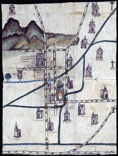
Some pre-Columbian and near-post-Columbian North American maps, such as the Nahuatl (Mexico) map below, showed winding rivers and winding trails as straight lines. The features between the rivers and trails had distorted positions to line them up with the straight rivers and trails.

enter image description here

This was very practical because one could not venture far off the trail. Therefore, the actual curves of the trail or river were unimportant, what was important was easily knowing what one would find up- or down-stream.

There are more maps and explanations on the NPR site.

$\endgroup$
3
3
$\begingroup$

Religion

Beings who have the astronomical ability to navigate by are going to notice that the stars in the night sky rotate around a point, and if they develop the mathematics and surveying technology necessary to make accurate maps, they're bound to work out the same map projections as humans did on Earth. But there's no reason for them to develop the "north at top" convention we use for the most part.

For centuries during the Middle Ages, maps were oriented with east at the top. That's why we have the verb "to orient". The best examples of these maps were "T and O" maps, with Jerusalem, the desination of Christian pilgrimage, in the center:

Hereford Mappa Mundi

(The Hereford Mappa Mundi, ca. 1300, source UNESCO, via Wikimedia Commons)

T and O maps developed because of a limited knowledge of the world by medieval Europeans.

Your alien mapmakers may have a convention that starts during such a time, with a map oriented towards an important cultural/religious location. However, there's no reason that has to change as that worldview expands.

$\endgroup$
3
$\begingroup$

Just enough intelligence to draw

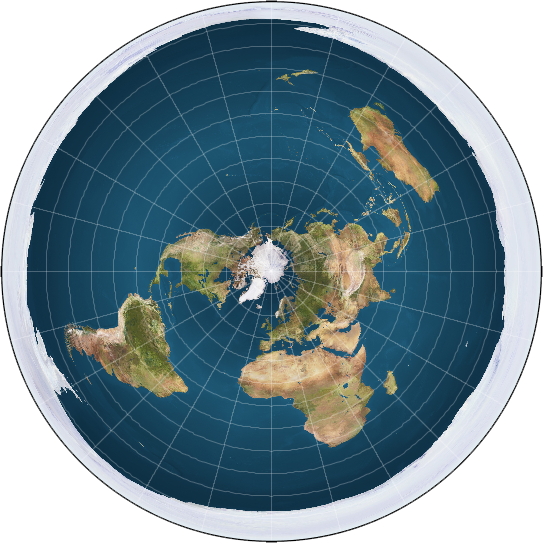
Or maybe they lack a neural region in their brain linked to basic match. If so, they might be unable to reason much beyond their senses, and they will think that the planet they live on is flat. This leads to some bizarre maps, with real weird justifications for a lot of things.

Flat Earth

$\endgroup$
1
  • $\begingroup$ But the Earth really is flat! (joking) $\endgroup$
    – overlord
    Commented Sep 24, 2019 at 19:06
2
$\begingroup$

Vernor Vinge's The Witling is set on a planet whose native humanoids can teleport. Teleporting preserves velocity: for example, if you jump to a higher latitude you're moving eastward relative to the destination; upward if you jump east.

Their maps show an orthographic view of the northern or southern hemisphere. From such a map you can read the local velocity directly. If you make jumps of equal length (map-length, that is) along a straight line on the map, you get the same kick each time; this is the easiest way.

$\endgroup$
2
$\begingroup$

As others pointed out, there are some well-explored ways to project a sphere onto a map sheet, including ones to preserve angles (e.g. Mercator) or to perserve areas (e.g. Gall-Peters). Each has advantages and drawbacks for various purposes, and there is mathematical proof that there is no projection to perserve angles, distances, and areas at the same time.

  • Have your aliens use an azimuthal equidistant projection centered on a holy city or capital. Then have some adventure set on the opposite end of the world, near the point which becomes the outer rim of the map. (The usual maps have two such points, but they are at the poles where few people live.)
  • Have them use a Peirce projection.

But in both cases you would have a flat map and one would have to know the continents to recognize how they are distorted.

$\endgroup$
1
$\begingroup$

Edit: I understand the OP is asking for 2D maps, but I decided to offer this as an alternative for anyone else who may happen by. :-)

What about a 1-D map?

The concept in a nutshell...

Consider this, your alien species have no sight. Perhaps they live at the bottom of an ocean. They may or may not possess some mental model of 2-D or 3-D, but for the purpose of composing and transferring information without sight, the only option I can think of is modulation of a serial stream of data. We have ways of doing this, the way I'm communicating with words right now is an example. Sound is another example.

So if your alien is blind, they may have some peculiar system of sounds or some nearly optimal system of conveying landmarks and instructions for navigation. Take a sentence of normal speech, this one for example. It conveys a concept, "example", an object "sentence", it has a context "navigation grammar", and meta-data "objective self-reference".

One could, in this regard, imagine a kind of grammar not used for conveying common ideas, but specifically ordered for the use of conveying spatial information, directions, or instructions for navigating, perhaps with some error correction. Note that language and grammar already have all of these qualities which have developed from hundreds of thousands of years of trial and error. Conversely, a species which has no sight, but can communicate and still needs to convey spatial information, could have as a part of the common language such mechanisms developed seamlessly into their own language.

This kind of usage may also influence the language as a whole. I won't go into detail about language studies, but there is a lot of information on the web about how the use of language shapes it's structure and grammar. There are good reasons why language is the way it is and it all boils down to the energy required to conceptualize things and communicate them. Life is an experiment in optimizing the use of energy and language is only one example.

Speculations about the structure of such a "map"...

So this kind of "map", if you would choose to call it that, is more like a set of directions than a 2-D map. And rightly so, as it is very inefficient to convey higher dimensional information in a lower dimensional format. Conversely it's much simpler and more efficient to convey lower dimensional information in a higher dimensional format. So we could think of it as a set of landmarks strung together with directions for how to proceed at each landmark. Pretty straight forward. But the interesting part is how one conveys the information. As a series of sounds, vibrations, perhaps these aliens have a mechanism for producing vibrations over the surface of their bodies, like shivers. To be more specific, sound is three dimensional, but we perceive it as a temporal series. And words are two dimensional, but we interpret them in the same way, as a temporal stream of meanings.

So to expand on the complex, temporal ( 1D ) ordered "map", think of bats. They use echo location to derive a sense of their surroundings, all from a temporal stream of sound, that which reaches their ears, and their brains parse the modulation of that sound and determine a sort of 3-D depth map where the level of detail increases as they get closer to things. For our "map" it could work the same way, but rather than being an echo, it could be encoded into the sounds. Furthermore, if these aliens have the ability to produce vibrations from most of the surface of their bodies ( consider autonomic contractions of the skin or shivers, but rather under conscious and directed control ). By controlling a series of shivers over the surface of the body, when the body is oriented in a given way, the output vibrations could be, in a way projected to produce a higher amplitude of vibration in some region of space ( or water ) near to and outside the body, or more specifically, close to the surface of the alien receiving the message.

So rather than saying "there's a rocky outcrop 100 meters ahead on your left", the alien might just say "big rock" while at the same time projecting some haptic feedback to the left side of the one listening where the haptic signal encodes information about size and distance to the rock from the current location or context on the "map". So 10 words in this way is reduced to 2 with some haptic feedback. In this way very long maps would be easier and faster to convey, they would contain a lot of information, the information would be very rich and, at least the human mind, would seem to have a easier time remembering them due to the richness of the information and the high level of abstraction.

$\endgroup$
1
$\begingroup$

Time Travelers

A time traveling race would want maps that portray the same area during multiple periods of time simultaneously. Perhaps, multiple two-dimensional layers in a block?

$\endgroup$
1
  • $\begingroup$ They could use one layer and color code levels of existence, or use different symbols for different time periods. A shoreline change could be dotted in different lengths or symbols for different centuries. Or amount of shading can denote former population or landmark expansions. Distances, depths and altitudes could be appended using codes for different ages. $\endgroup$
    – N2ition
    Commented Sep 24, 2019 at 22:05
1
$\begingroup$

I'll toss my hat in the ring, and focus on the idea of reasons why an alien would map the curved surface of a 3d object onto a flat 2d surface differently than we do on earth.

So, one way of looking at all the different projection schemes is: do you favor area or do you favor angles? Well, there's another, simpler way to look at it: what parts of the map do you care less about?

I mean, a polar map sucks at conveying information at the equator. Standard projections suck at conveying the poles. 'Sliced' style maps suck at conveying continuity at locations along the edges of the slices. One way or another, any 2D projection of a globe's surface will have segments of the globe that are conveyed badly.

Now, for us on earth, we're generally concerned with 45-to-45 latitudes (aka, stuff around the equator). That might not sound like a lot, but it covers all of Africa, almost all of South America, China, India, Australia, US/Mexico, and the southern half of Europe. Sure, there are people living closer to the poles, but that's not where the majority of earth activity happens. Because of that, it's no coincidence that pretty much every projection scheme is awesome at conveying information along the equator, and its weaknesses are all in some aspect of the land by the poles.

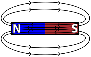
Once you look at the problem this way, the solution is obvious: make the aliens care about different sectors of the planet than we do. A great example: a planet where the only easily habitable areas are the north and south pole. Imagine a polar graph of the upper latitudes, with a second graph a bit beneath it that's a polar graph of the lower latitudes. Connect the longitudinal lines in a way that almost makes it look like a magnetic field diagram.

enter image description here

Sure, the information around the equator sucks... but the aliens reading that map wouldn't care - they just want the information on the parts they live at to be as accurate as possible.

$\endgroup$
0
$\begingroup$

Your aliens are water-breathing and never leave the water.

Thus they map only the underwater parts and don't care about the dry part. If they inhabit the entire range of depth, right down to the bottom, they need 3-D maps. They could carve them of coral or some such substance, or construct them of wires or sticks, and mark places of interest with stones or shells. Where the dry parts interrupt their world they can leave a space "terra incognita".

The oceans are not still, there are currents all over, and need to be shown too. A map of currents could be made of ribbons or strings attached to the 3-D map. I can imagine there would be signposts set up at important junctions.

$\endgroup$

You must log in to answer this question.

Not the answer you're looking for? Browse other questions tagged .