24
$\begingroup$

We all know about Rain Shadow - And if you don't now you do - and that the inner side of a mountain as compared to the ocean would be drier.

Now a worldbuiding problem going around that phenomenon. Imagine a large and wide valley (several dozens of miles wide in all directions) surrounded by tall mountains in all sides. Should be a desert, right? Except it is not. It is a lush and fertile land, with rainy seasons and extensive flora and fauna.

How can it be possible?

This is not so no frame challenges please. Stay so no magic. Within the premises above, what conditions would cause such an environment?

$\endgroup$
9
  • 2
    $\begingroup$ Have you thought about putting a lake in the center? $\endgroup$
    – dot_Sp0T
    Commented Jun 24, 2019 at 17:42
  • 3
    $\begingroup$ "surrounded by mountains on all sides" this seems at odds with being a wide valley... it has to have an outflow somewhere, right? It isn't a canyon or an endorheic basin... $\endgroup$ Commented Jun 24, 2019 at 17:44
  • 5
    $\begingroup$ Fertile is easy (convenient aquifers). Rainy is hard. $\endgroup$
    – user535733
    Commented Jun 24, 2019 at 17:54
  • $\begingroup$ Maybe this planet is very warm & it pretty much rains everywhere all the time. Sort of like what people guessed Venus was back in the early 20th century (see a couple Ray Bradbury stories, e.g.) $\endgroup$ Commented Jun 24, 2019 at 19:19
  • 1
    $\begingroup$ Maybe you are interested in having a look at the Sacred Valley. $\endgroup$
    – lvella
    Commented Jun 25, 2019 at 9:13

8 Answers 8

48
$\begingroup$

No explanation needed: Kashmir

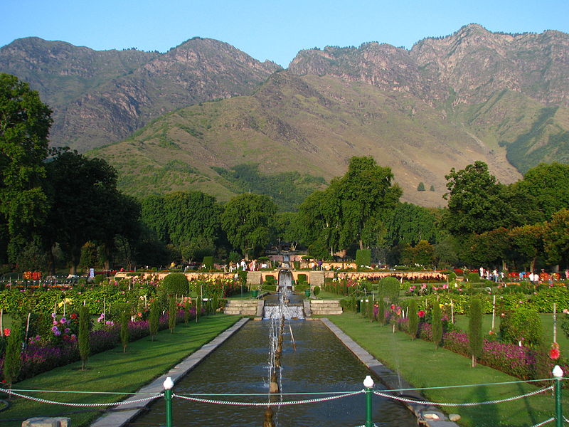
The famous Vale of Kashmir is the perhaps the best example on Earth, certainly in Western imagination, of an exotic and fertile valley surrounded by mountains. Below are some pictures of Srinagar and Dal Lake in summer and winter, with mountains in the background (sourced from Wikipedia).

enter image description here

enter image description here

The valley floor is about 1500 meters, and outside of the tropics. The much higher mountains to the north protect from the cold, so winter temperature get down to about freezing, but not much lower. Summer temperatures are mitigated by the altitude, topping out at about 30 C for the summer average (compared to 40 C plus in the sweltering plains below).

The valley is completely surrounded by mountains on all sides, with peaks over 4000 meters in all directions. The highest nearby peak is Nanga Parbat, about 100 km north of the valley. Despite its high surroundings, Kashmir sees moderate rainfall all throughout the year, including snow in the winter. It gets about 75% of the rainfall of areas with similar climates, such as Milan or Philadelphia; but about 30% more rain than the similar Xi'an in China.

Altogether, Kashmir sounds exactly like what you are describing.

$\endgroup$
13
  • 29
    $\begingroup$ Aye. There is no worldbuildiing like real-world examples. $\endgroup$ Commented Jun 25, 2019 at 15:41
  • 7
    $\begingroup$ Look east and there's the area around Chengdu in China. Mountains on all sides, humid subtropical climate, and far from being a desert most days are overcast with rain common all year. In South America, there's the Cauca Valley in Colombia, between the Occidental and Central Cordillera ranges. $\endgroup$ Commented Jun 25, 2019 at 17:23
  • 4
    $\begingroup$ Nice. But why don't the mountains around Kashmir block the rains then? $\endgroup$
    – ilkkachu
    Commented Jun 26, 2019 at 7:19
  • 2
    $\begingroup$ Doesn't really answer the question. $\endgroup$
    – duality_
    Commented Jun 26, 2019 at 8:05
  • 5
    $\begingroup$ @ilkkachu: Rain is about evaporation. The very fact that mountains block clouds from passing would mean that any water that evaporate within the valley will also condense and become a cloud above the valley and thus cause rain within the valley. And you would get a more or less closed ecosystem as far as water is concerned. $\endgroup$ Commented Jun 26, 2019 at 15:01
22
$\begingroup$

I give you Kelowna, British Columbia, and the Okanagan Valley. Surrounded by mountains, it's a humid continental climate with no shortage of vegetation and is certainly no desert.

For a larger example, the entire interior of British Columbia: between the Coast Range and the Rockies, the Interior consists of topographically lower plateaus and valleys with assorted climates, none of them desert-like.

$\endgroup$
1
  • 6
    $\begingroup$ Or going into the US, the Willamette River valley in Oregon: en.wikipedia.org/wiki/Willamette_Valley which I'm fairly sure is even rainier than the Okanagan. All that's needed is for the mountains on the upwind side of the valley to be lower than the downwind ones, and not so high that they block all the rain. Even California's Sacramento Valley can be pretty rainy in winter, though dry in summer, and is well-watered by runoff from the Sierra & Cascades. $\endgroup$
    – jamesqf
    Commented Jun 25, 2019 at 17:35
18
$\begingroup$

I think you have slightly misunderstood the rain shadow. It is caused by the mountains forcing the air flow upwards which in turn causes adiabatic cooling which causes rain. This in turn combined with the water from the rains running down hill away from the mountains means that mountains make more water come down from the atmosphere than goes back up in evaporation. This results in air behind the mountains after it goes back down and adiabatically warms not having enough moisture for rain.

There are few key points here. The big one is that it will rain in the mountains and your valley is surrounded by them. Significant portion of that water will end up in your valley naturally and any people living there would almost certainly build canals and such to hugely boost this. Even if it never rained in the valley, they'd still have access to water and probably a salt lake. Examples of how this works would be the Aral and the Dead Sea which with their associated rivers were important locations supporting rich early civilizations. Most early civilizations were in arid climates with water coming from mountains elsewhere, really. For managing water resources the Andean civilizations are the best reference. I think similar things happened in Yemen but that is probably less studied.

Second is that the valley is likely lot higher than the plains behind the mountains. So its probably not going to be in rain shadow at all. You can make it deep enough that rains pass over it but why would you? It is more realistic to expect lots of rain as the water condensed by the air flowing over the mountains comes down as rain over your valley. Western coasts of the Americas have lots of examples.

Third is that any water that comes down in a valley completely surrounded by high mountains will have a hard time escaping. You will probably have a lake in there. You can certainly easily get one by building a dam. And any evaporation that happens in the valley will be highly likely to get caught by the surrounding mountains and come back as rain on the mountains or as dew in the night. In essence your valley is going to have its own micro-climate that is probably less arid and more stable than the climate in the area in general. The classic example of this is Lake Titicaca and its valley.

$\endgroup$
11
$\begingroup$

Simplest answer is a very large warm water lake in the centre (Around the size of the great lakes if you can, but even a lake half as big will work, even as little as 25km in diameter is good enough to have some effect). The lake will change the pressure in the area, creating some small amounts of rain. The water table can be close to the surface, allowing trees to grow, and there can be frequent flooding of this lake (makes sense, the water has no where to go when it rains).

And that gives you a realistic fertile land that rains sometimes.

Here is a link explaining some of the effects the great lakes have on the weather. http://greatlakesliteracy.net/principles/3/

The Great Lakes influence local and regional weather and climate.

A: The Great Lakes affect weather and climate by impacting the basin’s energy and water cycles. Changes in the Great Lakes’ water circulation, water temperatures and ice cover can produce changes in weather patterns.

B: The Great Lakes warm by absorbing solar radiation. Lake temperatures are also affected locally by the temperature of inflowing river waters. The Great Lakes lose heat by evaporation and by warming the overlying air when the atmosphere is cool. After water vapor is released into the atmosphere, it condenses and forms precipitation, some of which falls within the Great Lakes Basin.

C: The Great Lakes modify the local weather and climate. Because water temperatures change more slowly than land temperatures, lake waters gain heat in summer and release heat during cooler months. This results in cooler springs, warmer falls, delayed frosts and lake effect snow.

D: The Great Lakes have a significant influence on regional climate by absorbing, storing and moving heat and water. Lake effect precipitation can occur downwind when major weather systems move over the lakes.

E: The Great Lakes are influenced by larger climate change patterns affecting North America and the world. Climate patterns in the Great Lakes are changing, with warmer and drier conditions predicted.

Depending on the height of the mountains, you have an interesting secondary concern, shorter days. This will help keep the area cool during the day, allowing for people to work harder and allowing plants to grow without being dried out.

$\endgroup$
7
  • 5
    $\begingroup$ Warm water lake could even be volcanic - would make sense in context of "surrounded by mountains on all sides". Normally no outflow = salty lake, but a volcanic crater is relatively "young". $\endgroup$
    – IronEagle
    Commented Jun 24, 2019 at 17:56
  • $\begingroup$ I really like this answer. I just wish that the OP's limit of "several dozens of miles" were big enough to permit this. +1 anyway. $\endgroup$
    – user535733
    Commented Jun 24, 2019 at 17:57
  • 1
    $\begingroup$ @user535733 It is. 24 miles is more than enough to do this. It should start to happen at around a 25km diameter. My parents live near a lake of that size, and it is amazing just how much it affects the local weather. You can watch storms on the horizon change direction suddenly to avoid the lake. Then it spins when it hits the lake creating water spouts. $\endgroup$
    – Trevor
    Commented Jun 24, 2019 at 18:09
  • 2
    $\begingroup$ @DavidRicherby, depending on how the mountains affect the weather patterns inside the valley, the lake could both be caused by the rain, and a significant cause of the rain. $\endgroup$ Commented Jun 26, 2019 at 21:19
  • 1
    $\begingroup$ high water table, glacial melt, one large freak rainstorm. Endless possibilities. And once it is there, it creates it's own weather. $\endgroup$
    – Trevor
    Commented Jun 27, 2019 at 12:28
9
$\begingroup$

I live in such a valley, Oregon's Willamette valley. It's roughly 25 miles wide, 100 miles long, and is extensively farmed.

The coast range, on the upwind side during the rainy season, is substantially lower (most peaks under 2000 feet) than the Cascades on the downwind side (most passes over 5000 feet). So, much of the water passes over the coast range and falls on the west side of the Cascades, from where it runs into the valley and is available for irrigation.

The coast range may not fit your idea of "tall mountains", but if you make them steep enough they should fulfill your plot's needs.

$\endgroup$
1
  • $\begingroup$ Yup, this is the easiest way to do it. Tall isn't a binary state. $\endgroup$ Commented Jun 26, 2019 at 16:29
6
$\begingroup$

Because the mountains aren't high enough to block all the rain clouds that come that way. This can be a function of:

A. Them actually being relatively low all around i.e. less than 1000m above sea level so they just don't block the rain, mountains of this size may seem small but if they're extensive and broken enough they'd still be impassable.

or

B. The mountains have wide passes at relatively low altitude that lets wet weather systems into the valley when they're moving in the right direction, this could make for a distinct wet and dry season if there is something like a monsoon weather cycle operating.

Alternatively the water may be in the form of glacial melt in which case the precipitation that supplies it need not occur within the valley but rather on outward facing slopes with the glaciers twisting back into the valley. Or even in the form of springs feeding through porous rock into the valley from outside.

The fertility is a given, if there's enough water coming into the valley it will be depositing rich sediment into the valley bottom creating and renewing a rich soil layer.

$\endgroup$
8
  • $\begingroup$ Or even that the mountain ranges run East-West and are much wider to the East, essentially "trapping" wind & clouds flowing to the West. $\endgroup$ Commented Jun 24, 2019 at 19:18
  • $\begingroup$ @CarlWitthoft Yeah that works but I'm not sure if it meets the "completely surrounded" bit of the question because I can't quite visualise what you mean by that. $\endgroup$
    – Ash
    Commented Jun 24, 2019 at 19:19
  • $\begingroup$ +1 about the water, but rocky precipitates are not particulary fertile, especially if all the fine particles get washed out with the underground river leaving the valley. $\endgroup$
    – Karl
    Commented Jun 24, 2019 at 19:29
  • $\begingroup$ @Karl What underground river? The valley may drain to ground water and it may only have evaporation as an outlet but neither of these necessarily allow for any transportation of sediment, no matter how fine, out of the system. $\endgroup$
    – Ash
    Commented Jun 24, 2019 at 19:32
  • 1
    $\begingroup$ Ground water == underground river. No outflow at all == regular flooding when the snow melts. $\endgroup$
    – Karl
    Commented Jun 24, 2019 at 20:12
3
$\begingroup$

The rain shadow effect could show its full influence further away from the valley. You can take the Kashmir valley in northern India as an example (https://www.google.com/maps/@34.0105983,74.6587664,9.01z/data=!5m1!1e4). It is surrounded by very high mountains but the rain shadow show its full effects only much further away in the Taklimakan desert while the valley still enjoys a fair amount of rain every single month. This is because the mountain range south-west of the valley is narrow enough not to produce large scale rain shadow effects directly in the valley.

$\endgroup$
1
$\begingroup$

There are a number of options.

Glaciers

There are glacier vallies up in the mountains and ithe ice flows provide water.

Aquifier surfaces

There is a water rich layer of rock, an underground river providing water to the valley for the ocean side.

$\endgroup$
3
  • $\begingroup$ If there are glaciers, there is snow and if there's snow, there are also meltwater rivers. Where's the snow coming from? $\endgroup$ Commented Jun 26, 2019 at 17:41
  • $\begingroup$ @David Richerby: Snow comes from the tops of the mountains. As for instance the Sierra Nevada: while much of the precipitation due to orographic lift falls on the west side of the summit, enough makes it over the divide to provide for numerous creeks and several fairly significant rivers, like, the Carson, Truckee, and Walker. $\endgroup$
    – jamesqf
    Commented Jun 26, 2019 at 19:49
  • $\begingroup$ @jamesqf Exactly: anything that creates glaciers will also create rivers, which are a much simpler explanation of the water in the valley. $\endgroup$ Commented Jun 26, 2019 at 20:08

You must log in to answer this question.

Not the answer you're looking for? Browse other questions tagged .