1
$\begingroup$

So climate is a pretty confusing subject, I've been searching for a very generalized map of climates. I wanna post it hear for some questions regarding this map enter image description here
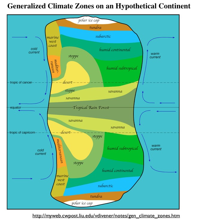
http://www.geocurrents.info/place/australia-and-pacific/australias-climatic-anomalies

Is this generalized map accurate?

$\endgroup$
9
  • 3
    $\begingroup$ With no scale on the axis is pretty hard to call that drawing a map. $\endgroup$
    – L.Dutch
    Commented Dec 13, 2018 at 7:08
  • 1
    $\begingroup$ @L.Dutch, it goes from pole to pole, it doesn't need a scale as it's proportional and also fairly approximate. $\endgroup$
    – Separatrix
    Commented Dec 13, 2018 at 8:43
  • $\begingroup$ @Separatrix Thank you for addressing that, I fell asleep. But yea just pole to pole I doubt a scale is needed $\endgroup$ Commented Dec 13, 2018 at 8:56
  • 1
    $\begingroup$ You need to specify the latitude on the map, and at least the radius of the planet to get a feeling of the extension of the continent. Without those info we can just give wild guesses. Hint: the tropic position depends on the axial tilt. $\endgroup$
    – L.Dutch
    Commented Dec 13, 2018 at 9:05
  • $\begingroup$ @L.Dutch I've been doing research on the topic and now the second part of the question has been removed. Now the question is in your opinion is this very generalized climate map accurate? $\endgroup$ Commented Dec 13, 2018 at 9:10

1 Answer 1

1
$\begingroup$

As a generalized map, sure it is accurate enough. Is it realistic? Not really, but that isn't the point of this map. The hypothetical continent shows ideal climates (as stated in the article you link to) as a learning tool. Real world climates are not ideal, nor are continents symmetrical. This continent also conspicuously lacks any large bodies of water on it or mountain ranges, both of which can significantly affect regional climate.

$\endgroup$

Not the answer you're looking for? Browse other questions tagged .