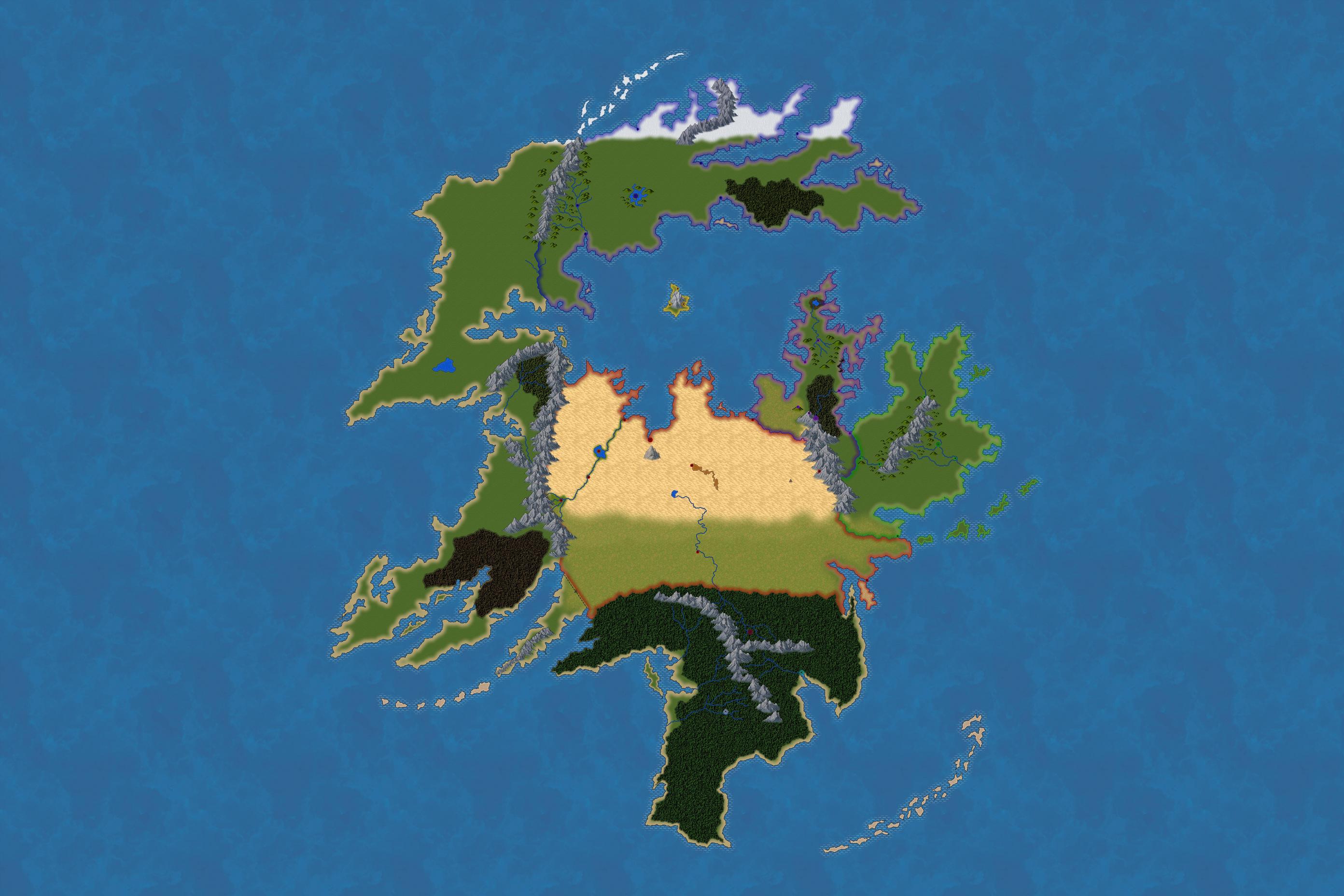
I am requesting feedback on my in-progress fantasy world map, primarily in 4 major areas:
- biomes
- rivers
- cities
- borders
Do they make sense? If not, what should I change? Any observations or inferences concerning my world's geopolitics are also welcome.
Higher Resolution Here.
Additional information:
- The sea in the center of the map is roughly analogous to the Mediterranean in terms of size and location.
- Colored dots are major cities. The larger dots with stars are capitals. Diamond-shaped markers are sites of significance, but not settlements. Triangles are ruins. The dashed line is a ruined ancient wall. Smaller towns, villages, and military outposts are not shown (yet).
- There are five major nations, represented by Blue (theocratic autocracy), Yellow (mercantile oligarchy), Red (tribal confederacy), Purple (unitary monarchy), and Green (feudal state). Blue, Red, Purple, and Green have all clashed historically, but are currently at peace. Red and Purple share cultural ties and have established a mutual respect. Yellow is the youngest nation and currently has the most influence due to having gained control, directly or indirectly, of virtually all sea trade. They managed to do this because their island is abundant in valuable resources (mountain salt mines and pigments according to my notes, but it could easily be something else) and they skillfully played the surrounding nations against each other until they became strong and rich enough to run the table on everyone else. Yellow is the keystone holding the peace together.
- The Red city in the middle of the desert gets their water from underground aquifers. The Red city next to the eastern mountains gets theirs from a spring.
- The lonely mountain in the desert is an inactive volcano.
- Three city-states (Maroon, Teal, Silver) occupy the southern jungle. They will conduct trade but mostly stay out of each other's way. Maroon also trades with Red, while the other two have no interest the outside world. Teal has a strong nautical culture and follows a pattern of yearly migration to and from the southeastern archipelago. They also have an ongoing feud with the shark-people who inhabit those waters.
- Nomads occupy the northwestern steppes and occasionally harass Blue's borders. Blue has attempted to conquer them in the past to no avail.
- The forested valley tucked into the western mountains is occupied and fought over by two relatively small rival tribes. They have no contact with the world outside their valley.
- The southwestern peninsula is currently uninhabited, but used to be a powerful empire.
If you want to see the changes I'm already considering and give feedback on them, you can find my markup of the map here.

