added 9 characters in body
Source Link
Samuel
  • 48.6k
  • 10
  • 145
  • 232

There are some features/properties that will aid in the selection of features. These aren't rules, but guidelines. For instance:

Winds and hemispheres
If there are high waves there will be more erosion and the coastline will more likely have been pushed landward until it hit some rocky materials to slow the encroachment. The high waves are caused by high winds. So, these rocky coasts are characteristic of the west coasts in the northern hemisphere and the east coasts in the southern hemisphere. This is not a rule though.

There are some features/properties that will aid in the selection of features. For instance:

Winds and hemispheres
If there are high waves there will be more erosion and the coastline will more likely have been pushed landward until it hit some rocky materials to slow the encroachment. The high waves are caused by high winds. So, these rocky coasts are characteristic of the west coasts in the northern hemisphere and the east coasts in the southern hemisphere. This is not a rule though.

There are some features/properties that will aid in the selection of features. These aren't rules, but guidelines. For instance:

Winds and hemispheres
If there are high waves there will be more erosion and the coastline will more likely have been pushed landward until it hit some rocky materials to slow the encroachment. The high waves are caused by high winds. So, these rocky coasts are characteristic of the west coasts in the northern hemisphere and the east coasts in the southern hemisphere.

added 993 characters in body
Source Link
Samuel
  • 48.6k
  • 10
  • 145
  • 232

It's pretty much random.

It's pretty much random. But that's a good thing, because it allows for creativity.

The main driving factor here is erosion. The coastal details are random, but some major features depend on the type of land at the coast. Here is a collection of major features for a coast and a bit about how they are formed:

  • First we can discuss a collection of major features for a coast and a bit about how they are formed.
  • Then a couple notes on how to get the big features right.
  • Finally some sources for generating your coastlines automagically.

The features:

Roughly from left to right:

Getting some clues:

There are some things you can get a good guess atfeatures/properties that will aid in the selection of features. For instance:

  • An offshore reef will significantly reduce the wave strength and you'll get some fairly lackluster beaches. They'll mostly be sediment build up and will likely result in shallow beaches (look at beaches on the Australian mainland inside of the great barrier reef for good examples).
  • If there are high waves commonly there will be more erosion and the coastline will more likely have been pushed landward to some rocky materials.

Reefs and offshore features
An offshore reef or island will significantly reduce the wave strength and you'll get some fairly lackluster beaches. They'll mostly be sediment build up and will likely result in shallow beaches (look at beaches on the Australian mainland inside of the great barrier reef for good examples).

Note:Winds and hemispheres
IIf there are high waves there will be more erosion and the coastline will more likely have been pushed landward until it hit some rocky materials to slow the encroachment. The high waves are caused by high winds. So, these rocky coasts are characteristic of the west coasts in the northern hemisphere and the east coasts in the southern hemisphere. This is not a rule though.

Latitudes
If the coastline is filling an area forged by a recent ice age or glacial activity, then large cliffs may be more prolific. The glaciers will have carved out deep valleys, leaving bedrock as the headland which resists rapid erosion. See the fjords in near-arctic regions for examples.

Automagical generation:

Coastlines can be passibly simulated using fractal landscape generation.

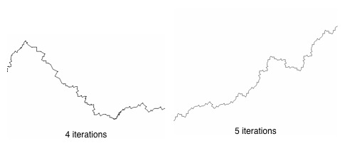
I found this article, which describes how the author algorithmically produces a coastline fractal by adding a random component: enter image description here
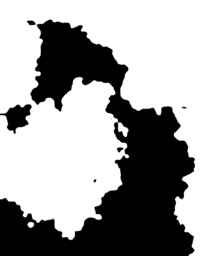
Also this one doing a similar process:
enter image description here

These are both using a fractal landscape type of generation.

It's pretty much random.

The main driving factor here is erosion. The coastal details are random, but some major features depend on the type of land at the coast. Here is a collection of major features for a coast and a bit about how they are formed:

There are some things you can get a good guess at. For instance:

  • An offshore reef will significantly reduce the wave strength and you'll get some fairly lackluster beaches. They'll mostly be sediment build up and will likely result in shallow beaches (look at beaches on the Australian mainland inside of the great barrier reef for good examples).
  • If there are high waves commonly there will be more erosion and the coastline will more likely have been pushed landward to some rocky materials.

Note:
I found this article, which describes how the author algorithmically produces a coastline fractal by adding a random component: enter image description here

Also this one doing a similar process:
enter image description here

These are both using a fractal landscape type of generation.

It's pretty much random.

But that's a good thing, because it allows for creativity.

The main driving factor here is erosion. The coastal details are random, but some major features depend on the type of land at the coast.

  • First we can discuss a collection of major features for a coast and a bit about how they are formed.
  • Then a couple notes on how to get the big features right.
  • Finally some sources for generating your coastlines automagically.

The features:

Roughly from left to right:

Getting some clues:

There are some features/properties that will aid in the selection of features. For instance:

Reefs and offshore features
An offshore reef or island will significantly reduce the wave strength and you'll get some fairly lackluster beaches. They'll mostly be sediment build up and will likely result in shallow beaches (look at beaches on the Australian mainland inside of the great barrier reef for good examples).

Winds and hemispheres
If there are high waves there will be more erosion and the coastline will more likely have been pushed landward until it hit some rocky materials to slow the encroachment. The high waves are caused by high winds. So, these rocky coasts are characteristic of the west coasts in the northern hemisphere and the east coasts in the southern hemisphere. This is not a rule though.

Latitudes
If the coastline is filling an area forged by a recent ice age or glacial activity, then large cliffs may be more prolific. The glaciers will have carved out deep valleys, leaving bedrock as the headland which resists rapid erosion. See the fjords in near-arctic regions for examples.

Automagical generation:

Coastlines can be passibly simulated using fractal landscape generation.

I found this article, which describes how the author algorithmically produces a coastline fractal by adding a random component: enter image description here

Also this one doing a similar process:
enter image description here

added 134 characters in body
Source Link
Samuel
  • 48.6k
  • 10
  • 145
  • 232

It's pretty much random.

The main driving factor here is erosion. The coastal details are random, but some major features depend on the type of land at the coast. Here is a collection of major features for a coast and a bit about how they are formed:

enter image description here$_{Source}$

  • Beaches are formed primarily of the sediment deposited along a coast from the erosion of a surrounding cliff, or bluff.
  • A rocky cliff is made up of material which is relatively resistant to erosion such as sandstone, limestone or granite, a flat rocky wave-cut platform or abrasion platform is formed in front of the cliff.
  • The headland is the land on top of the cliff.
  • (Not listed) A bay is a beach surrounded by headlands.
  • Sea caves are made when certain rock beds are more susceptible to erosion than the surrounding rock beds because of different areas of weakness. These areas are eroded at a faster pace creating a hole or crevasse that, through time, by means of wave action and erosion, becomes a cave.
  • Natural arches are formed when a sea cave is eroded through by waves.
  • Stacks are formed when a headland is eroded away by wave and wind action or a natural arch collapses.
  • Stumps are shortened sea stacks that have been eroded away or fallen because of instability.
  • A skerry is an eroded stack.
  • Spits are formed by ocean currents colliding and depositing materials.
  • A tombolo is formed when a spit connects to an existing island or builds up enough to create an island.
  • A rocky islet is a small island. Perhaps a disconnected tombolo or a isolated skerry.
  • A river estuary is a bay or inlet with a river flowing into it.
  • Sand islands are disconnected spits or the result of river deposits.
  • Dune is a planet with giant worms and spice. Also a pile of sand.
  • A lagoon is separated body of water, usually salty, and occurs quite frequently. Most of these features can occur anywhere, but have a better chance of sticking around depending on what the land is composed of.

There are some things you can get a good guess at. For instance:

  • An offshore reef will significantly reduce the wave strength and you'll get some fairly lackluster beaches. They'll mostly be sediment build up and will likely result in shallow beaches (look at beaches on the Australian mainlandbeaches on the Australian mainland inside of the great barrier reef for good examples).
  • If there are high waves commonly there will be more erosion and the coastline will more likely have been pushed landward to some rocky materials.

Note:
I found this article, which describes how the author algorithmically produces a coastline fractal by adding a random component: enter image description here

Also this one doing a similar process:
enter image description here

These are both using a fractal landscape type of generation.

It's pretty much random.

The main driving factor here is erosion. The coastal details are random, but some major features depend on the type of land at the coast. Here is a collection of major features for a coast and a bit about how they are formed:

enter image description here$_{Source}$

  • Beaches are formed primarily of the sediment deposited along a coast from the erosion of a surrounding cliff, or bluff.
  • A rocky cliff is made up of material which is relatively resistant to erosion such as sandstone, limestone or granite, a flat rocky wave-cut platform or abrasion platform is formed in front of the cliff.
  • The headland is the land on top of the cliff.
  • (Not listed) A bay is a beach surrounded by headlands.
  • Sea caves are made when certain rock beds are more susceptible to erosion than the surrounding rock beds because of different areas of weakness. These areas are eroded at a faster pace creating a hole or crevasse that, through time, by means of wave action and erosion, becomes a cave.
  • Natural arches are formed when a sea cave is eroded through by waves.
  • Stacks are formed when a headland is eroded away by wave and wind action or a natural arch collapses.
  • Stumps are shortened sea stacks that have been eroded away or fallen because of instability.
  • A skerry is an eroded stack.
  • Spits are formed by ocean currents colliding and depositing materials.
  • A tombolo is formed when a spit connects to an existing island or builds up enough to create an island.
  • A rocky islet is a small island. Perhaps a disconnected tombolo or a isolated skerry.
  • A river estuary is a bay or inlet with a river flowing into it.
  • Sand islands are disconnected spits or the result of river deposits.
  • Dune is a planet with giant worms and spice. Also a pile of sand.
  • A lagoon is separated body of water, usually salty, and occurs quite frequently. Most of these features can occur anywhere, but have a better chance of sticking around depending on what the land is composed of.

There are some things you can get a good guess at. For instance:

  • An offshore reef will significantly reduce the wave strength and you'll get some fairly lackluster beaches. They'll mostly be sediment build up and will likely result in shallow beaches (look at beaches on the Australian mainland inside of the great barrier reef for good examples).
  • If there are high waves commonly there will be more erosion and the coastline will more likely have been pushed landward to some rocky materials.

Note:
I found this article, which describes how the author algorithmically produces a coastline fractal by adding a random component: enter image description here

Also this one doing a similar process:
enter image description here

These are both using a fractal landscape type of generation.
It's pretty much random.

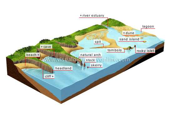
The main driving factor here is erosion. The coastal details are random, but some major features depend on the type of land at the coast. Here is a collection of major features for a coast and a bit about how they are formed:

enter image description here$_{Source}$

  • Beaches are formed primarily of the sediment deposited along a coast from the erosion of a surrounding cliff, or bluff.
  • A rocky cliff is made up of material which is relatively resistant to erosion such as sandstone, limestone or granite, a flat rocky wave-cut platform or abrasion platform is formed in front of the cliff.
  • The headland is the land on top of the cliff.
  • (Not listed) A bay is a beach surrounded by headlands.
  • Sea caves are made when certain rock beds are more susceptible to erosion than the surrounding rock beds because of different areas of weakness. These areas are eroded at a faster pace creating a hole or crevasse that, through time, by means of wave action and erosion, becomes a cave.
  • Natural arches are formed when a sea cave is eroded through by waves.
  • Stacks are formed when a headland is eroded away by wave and wind action or a natural arch collapses.
  • Stumps are shortened sea stacks that have been eroded away or fallen because of instability.
  • A skerry is an eroded stack.
  • Spits are formed by ocean currents colliding and depositing materials.
  • A tombolo is formed when a spit connects to an existing island or builds up enough to create an island.
  • A rocky islet is a small island. Perhaps a disconnected tombolo or a isolated skerry.
  • A river estuary is a bay or inlet with a river flowing into it.
  • Sand islands are disconnected spits or the result of river deposits.
  • Dune is a planet with giant worms and spice. Also a pile of sand.
  • A lagoon is separated body of water, usually salty, and occurs quite frequently. Most of these features can occur anywhere, but have a better chance of sticking around depending on what the land is composed of.

There are some things you can get a good guess at. For instance:

  • An offshore reef will significantly reduce the wave strength and you'll get some fairly lackluster beaches. They'll mostly be sediment build up and will likely result in shallow beaches (look at beaches on the Australian mainland inside of the great barrier reef for good examples).
  • If there are high waves commonly there will be more erosion and the coastline will more likely have been pushed landward to some rocky materials.

Note:
I found this article, which describes how the author algorithmically produces a coastline fractal by adding a random component: enter image description here

Also this one doing a similar process:
enter image description here

These are both using a fractal landscape type of generation.

added 654 characters in body
Source Link
Samuel
  • 48.6k
  • 10
  • 145
  • 232
Loading
added 433 characters in body
Source Link
Samuel
  • 48.6k
  • 10
  • 145
  • 232
Loading
Source Link
Samuel
  • 48.6k
  • 10
  • 145
  • 232
Loading